Browsing posts in: Bicycling

Tour de Blast 2017

After deciding not to do the full Flying Wheels route this year, I wanted a substitute, and I decided to journey south to Castle Rock to ride Tour de Blast. My wife came along to ride the 30, and planned to do the full 82.

We left Friday afternoon at 2:30, and spent a full 4 hours getting down to Castle Rock. It’s quite a ways even if there is no traffic, which of course never happens around here any more. As much as I hate getting up early to ride, I would almost prefer to do that and miss the traffic. We stayed in the TimberLake Inn in Castle Rock and had a decent mexican dinner that night.

We woke up the next morning at 6AM, and I had a wonderful meal of a chocolate brownie clif bar, some blueberries, and a glass of water. I’ve been eating low (er) carb, and I’m still trying to figure out what I want to eat before a ride and didn’t plan well ahead of time, so it was whatever I could find it the store.

We left the hotel at around 7 and got to the start at maybe 7:25, parking in the baseball outfield. Then it was a walk to pick up our packets, a walk back, and I headed out.

Well, not quite; I spent a lot of time trying to decide what to wear and what to carry; the ride has a reputation of cold (and wet) at the top, and even though the forecast was decent it tends to be windy up there. I settled on arm warmers, no leg warmers, summer gloves, and I couldn’t decide on whether to carry my stuffable vest or my stuffable jacket, so I ended up carrying both. Plus phone, cheez-it’s and electrolyte tablets.

The ride profile looks like this:

I like to break rides into sections so I can keep them straight in my mind. For this ride there is:

  1. Warmup – the first 18 miles or so, which has a little over 1000′ of up.
  2. Elk Rock climb – 2200′ of up over 7.7 miles
  3. Descent + Johnson Ridge climb – 1650′ over 5.7 miles
  4. Descent + Elk Rock backside – 1400′ (ish) over about 8 miles
  5. Return to start: 3250′ down over 27 miles.

Here’s a 3d view of the route:

image

Warmup

I am just warm enough as I spin out of town with my stuffable vest on. We have a little flat, and then slowly start to climb up; there’s a lot of road in the 1-2% range, with a few kickers in the 6% range. I pass quite a few people, but since this is a three-route ride (there is a 30 and a 52 variant), that doesn’t really mean much. My legs feel decidedly meh and my stomach is a bit weird, but I’m okay overall. I’m trying to climb at about 175 watts, which is a pretty good “all day” pace for me generally. I push it up to 225 on one of the kickers, and feel a little bit better, which is a good sign.

At 15 miles we hit the first rest stop; I have drank maybe a third of my two bottles so I just keep going. Right near the 20 mile mark, we hit the start of the Elk Ridge climb.

You can always tell when the highway engineers got involved when you are riding in the mountains, because the gradient is typically arrow-straight. You wind around, you go over bridges, but the gradient is very constant, at about 5%, with a little over and a little under in places. I start at about 200 watts but decide that’s a little too high, so I drop down to about 180, and average 181 watts for the whole climb. My vertical meters per hour is a disappointing 550, but I do have a couple of significant climbs in front of me.

The climb itself is okay; the road itself is chipseal but they nicely decided to leave a little margin on the shoulders uncoated, so there is generally smooth surface to ride on. The bridge are big and long and provide either beautiful views or slightly scary heights depending on your perspective.

I pass people, people pass me, and I spent a bit of time chatting with those who are close to my speed. 70 minutes or so later, I hit the Elk Rock rest area. My stomach is still feeling a bit weird on my electrolyte drink, so I fill up my empty bottle with water, have a couple of potatoes with salt, skip the grilled hot dogs, and head back out.

Johnson Ridge

A short bit of up and I find myself on the Elk Rock descent. It’s a nice descent, broken in two by a short and easy (2%) uphill section, with a couple of sweeping turns. Most of the time I spend in the low 30s, spun out in my largest gear, and 8 miles doesn’t take that long at that sort of speed. I’m now back down to 2500′ and will need to climb up over 4000′.

Johnson ridge is named after David Johnson, a geologist who was on the site when the mountain erupted on May 18th, 1980. It provides – weather permitting – a spectacular view into the crater.

But first we have to get up there…

I felt pretty good on the descent, but as I ramp up for the climb, that feeling dissipates, and I am left with some nice low-grade nausea. Nothing really seems to help; water makes it worse, electrolyte drink makes it worse, cheez-its (which I generally tolerate very well) make it worse. The only thing to do is to stop drinking and keep climbing.

This climb is harder than the Elk ridge one, as the grade is often in the 7-8% range and touches 9-10% in places. I whine to myself, suffer, get passed, suffer, get passed some more, and keep going. My butt is a bit sore, my back/shoulders hurt, my stomach is upset, my pulse is pounding in my head, my head aches a bit, and my tinnitus is acting up.

The only thing really keeping me going is the knowledge that I have an out – my wife is planning on driving up to the observatory after she finishes (which she already did), so I have the option of hanging around and waiting for her. An estimated 35 hours later, I finally top out (actually, looking at the data, I climbed the 1650′ in 54:33 @ 553 meters / hour and 171 watts, so pretty much the same pace as the first climb. Did not feel that fast.

I walk up to look at the mountain (covered in clouds), and head to the food tables. I carefully get off my bike, take a drink (nope, still feel sick), text the wife (a really poorly worded “At top. Probably done”), and chance half a banana. Nope, still feel sick. Start composing my ride report, and decide to call it “Tour de Fizzle”.

Sit around in the sun a bit, talk to one of my friends about my new bike, sit on a bench, and finally am able to get some fluid down without feeling horrible. Wait for the wife, and wait some more.

Elk Rock Backside

Finally get cold and am feeling better, and decide I need to get down off the hill, and hope my wife stops when she passes me on this section. This descent is fast, my arms are shaking because I’m cold so I can’t steer very well, and my wife passes me headed up maybe 2 minutes into the descent. Sigh.

A couple minutes later I drop farther into the valley, it warms up maybe 15 degrees, and I stop shivering. Down, down, and down, and I’m back in the valley between the ridges, and it’s time to climb up. Coat off and put away, arm warmers off and put away.

This first part is the steeper part of the climbs; I saw 8% on the downhill and expect it to be pretty bad coming back up, but I set a power target of 150 watts and climb @ 5-6 MPH and it’s really not that bad. I pass a few, get passed by a few others, and finally reach an intersection that marks the end of the steeper part. A short descent, and then it’s onto the longer but flatter upper section.

This is supposed to be easier, but I feel worse than the first section, and I’m climbing at a seriously slow 130 watts. I stop a couple times to rest, and then see my wife pass me going the other way, and when I don’t see the car at one of the pull-outs, I know that my lack of good instructions means she went back to the starting point to wait for me. I stop a couple more times, and the last time my background nausea asserts itself, and I sit there trying to control my stomach for a couple of minutes. Successful, I get on the bike and continue the upward grind. I am climbing at a breathtaking 340 meters/hour.

Finally we top out again, and I pull into the Elk Rock food stop for a second time. Nothing looks good and I don’t really need water and there’s no cell service, so I can’t text my wife, so it’s back on the bike and heading down. At least it’s a descent, and I descend all the way down to the site of the first food stop, pull over, and text my wife that I am starting down and to come and find me. And she does, meeting me at the 72 mile point, which ends my ride for the day. A bit of jerky (which I stupidly chose not to stuff in my pockets) and a full coke zero, and I feel somewhat human. Just in time for the 4:30 drive back, which thankfully I did not have to do.

Stats etc.

71.6 miles and 7001′ of up with a moving time of 5:45 and an elapsed time of 7:00. So, slow and with more than double the time off the bike I would expect. It ended up as an “Extreme” suffer score of 230, but I think the only time I’m suffered more on the bike was the time I climbed up Cayuse in 100+ temperature.

Overall, the ride is okay. I liked it much better than High Pass Challenge because it doesn’t have all the flat section. Will I do it again? Well, it’s a long trip to get down there and a long trip back, and that does deaden the experience a bit, but maybe.


From carb-optimized to fat-optimized: a brief summary

(I’ve written this from a cycling perspective, but I think the basic idea – going from a carb-optimized metabolism to a fat-optimized one – has a broader application).

For those who don’t know me, I’m a fairly typical recreational cyclist; in season I’m riding 3 times a week, generally anywhere from 75 miles to 120 miles, with a few goal events (I tend toward hilly events, such as RAMROD, Passport 2 Pain, and my very own Sufferin’ Summits).

Over the years, I’ve mostly used a low-fat diet; one focusing on low-GI carbs (brown rice, whole-wheat bread, etc.) for my normal diet, and one with high-GI carbs before, during, and after my rides.

That has worked okay, more or less, with a few issues:

  • My stomach is often not very happy with a slug of sugar-based nutrition drink during a ride (I have fructose intolerance, which may be part of it).
  • I generally feel tired when I get to about 4 hours on the bike. Not leg tired, but just a general overall feeling of fatigue.
  • I have a really hard time not snacking between meals. This was not helped by having candy readily available at work, but even without that, I still had a hard time not snacking.
  • I also had a related problem. I ski and teach skiing during the winter, which means that I have no weekend time for rides from December through mid-March, and a lot of chance to snack after skiing. Those combined with my work snacking, and in early 2016 I was at 178 lbs, about 6 lbs above my traditional adult weight of 172 lbs.

    Some of you may be saying, “that’s not that heavy for an athlete”, and that’s true, but I did not like the trend.

    I read a book on nutrition that had been sitting on my Amazon wish list for a year (reference below), I asked a few cyclists at my company about their experience with a lower carb approach. And I did a lot of research about nutrition and metabolism in general; if you want to talk about insulin, glucagon, ketosis, I can go on for quite a while, and I can also talk a bit about the current state of clinical measurements (HDL, LDL, LDL-P) and their relation to cardiovascular disease.  Oh, and the experience of indigenous people such as the Inuit and what happened when they started to eat a western diet.

    My conclusion was that I was eating quite a few carbs in my diet and not much fat, which meant that my body was going to be optimized towards using carbs as a fuel source. My other conclusion was that eating the carbs was contributing to my snacking, because a) the insulin response to the carbs would tend to drop my blood sugar back down and b) the lack of fat wasn’t making me feel satisfied after a meal.

    So, it was time to experiment. I’m not somebody who likes to make giant changes in my diet all at once, so I focused on lunch, especially at work. Here’s what I was eating before:

    Monday: Burrito day. A whole wheat burrito, black beans, rice, chicken breast, cheese, guac
    Tuesday: A half sandwich; chicken/turkey breast, cheese, lettuce, tomatoes, pickles, mustard
    Wednesday: See Tuesday
    Thursday: Taco salad day. In a tortilla bowl, black beans, rice, chicken breast, lettuce, guac, olives, cheddar cheese
    Friday: See Tuesday

    Just writing that, wow, that’s a lot of carbs. And wow, my cafeteria is boring.

    Here’s what I switched to:

    Monday: Mexican day. Black beans, half chicken & half pork, onions, lettuce, cheese, guac
    Tuesday: “Barbecue day”. Either brisket or a half chicken with cole slaw, and a tiny square of cornbread
    Wednesday: Salad. Greens + tomatoes, cucumbers, peas, kidney beans, red bell pepper, sugar peas, olives, mozarella balls, eggs, and chicken thight. All topped with an oil/balsamic vinegar dressing.
    Thursday: Mexican day repeat
    Friday: Salad repeat

    Gone are tortillas, bread, rice. Added in are more vegetables, and considerably more fat (pork, brisket/whole chicken, chicken thighs, salad dressing)

    The change was surprisingly easy, with the hardest part being changing my perception of fat. And I noticed an immediate effect on how I felt at work; I was less tired in the afternoon and I stopped snacking totally (it did help that the snacks moved out of my room).

    I switched out my sugar-based hydration drink with an electrolyte one (Nuun has bothered my stomach and I don’t like plain water on rides, so I’m using Hammer’s right now), and went on a few rides.

    And hated it. I means, seriously hated it. I was not running out of energy per se, nor did I have much hunger, I just could not put out any power to save my life. I played around with food with different levels of carbs before and during (I still think a carb recovery drink makes a lot of sense after a long ride), and it has gotten better but I don’t think I have that part figured out yet. More about that later.

    That was working well, so attacked my breakfast next, which was a bowl of granola with fruit. I added an egg (sometimes two) in the morning and reduced the granola, and that’s where I am right now. I honestly probably need a bit more fat in the morning but it is so hard to change ingrained habits. I also changed my dinner patterns a little, trying to focus more on the protein/fats and the vegetables and less on the carbs. Also still a work in progress.

    Oh, and for snacks at home, I’m eating cheese, home-made jerky (time to make a new batch…), and a fair bit of nuts. I’ll have some popcorn now and then, and maybe some chips.

    One thing to stress is that, with the exception of paying attention to my snacking habits at work – where I have a “drink a glass of something first before you eat” rule – I’ve put pretty much zero effort into limiting my portion sizes. I just eat what seems decent, and stop when I am done.

    Results:

    My expectations weren’t very high; I would be happy if I got down to my usual weight and felt a little better on the bike.

    What happened is that in about 3.5 months, I lost a full 10 pounds of weight, clocking in at 168 lbs this week. My summer shorts fit nice and loose, and today I pulled on a pair of 501s that I hadn’t worn for about 9 months, and they fit fine.

    On the bike, I’m feeling strong but I feel like I might be missing a bit of my top end. On the other hand, last week I took 33 seconds off of my PR on a 7 minute climb and some of my riding friends say I’m faster, so maybe it’s not as big as I think, or maybe it’s just different. I have definitely felt less tired after a few hours on the bike, and my stomach is much happier on the bike.

    References:

    For a lot of reasons, low-carb is still fairly controversial and a number of sources say that its not healthy and you’ll grow a third arm or something. Much of that is due to the evolution of thought around the role of cholesterol levels in the blood, from “cholesterol = horrible” to “HDL / LDL” to “hey maybe LDL as a measure doesn’t work, how about LDL-P”. Remember that dietary guidelines have a *huge* lag time behind current research, and there is lots of out of date advice out there.

    If you read anything, read a copy of “Why we get fat” by Gary Taubes. He may not have the whole story from a biochemical standpoint, but his overall presentation is very good. If you like lots of details, read his “Good Calories, Bad Calories“, but be prepared to bone up on your biochemistry.

    Joe Friel – author of many training books for endurance athletes – has written some very interesting blog posts about low carb. In “Aging – My Race Weight“, he details an experience very similar to mine. Read “Becoming a better fat burner“. And read the comments on these posts as well.

    If you are looking for research into low carb and performance, there is a decent summary here. Note that most of the investigation has been purely around performance, and the results seem pretty clear that low carb does not increase performance and may take a bit off the top end (perhaps in some people, perhaps in all). What the studies miss are the things that I really care about; if I don’t have to eat as much on the ride, I avoid the stomach issues that I’ve had over the years, I (hope) that I will have less trouble with low energy during the ride, and the obvious performance advantages of less weight.

    If you want more details and/or references, please let me know in the comments.


    Quick Review: Specialized Roubaix Expert Di2

    A long time ago – in 2004 or so – I bought my first high-end road bike, a 2005 Trek Madone 5.2, and over the years, I probably put around 30,000 miles on the bike. It has been a great bike.

    But my early-50s body is not as flexible as my 40-year-old body was, and I’ve been having some persistent shoulder and neck issues despite having a good fit and spending some quality time with a PT, so it was clear that it was time to do some bike shopping.

    And yes, it’s very clear that I am different than many of my riding companions, who seem to rotate their bikes every 3 or 4 years, or the rest of my riding companions who subscribe to the “N+1” theory of bike ownership (see footnote).

    On my shopping list:

    • A smaller frame (my Trek is a 60cm, and a 58 seemed like a better choice)
    • Disc brakes, because I’m doing a lot of steeps and I’m tired of wondering if I will stop at the bottom.
    • Low gearing. With the hills I climb, I need something close to 1:1.
    • Full Ultegra (or very close) for the groupset.
    • A bike tuned towards the kind of riding I do (ie endurance) rather than racing. A little more compliant, a little more comfortable, and a little more upright.
    • A decent color combination. My Madone is a Project One featuring the “Pave Flambe” paint scheme (bright red with flames), and I’m not a big fan of colors like white, black, or charcoal.

    Armed with that list, I headed out to the bike manufacturer websites and started coming up with options.

    Well, that’s actually not quite true; what I *really* did was procrastinate for about 9 months, scrawl a list of bikes on a piece of paper that I promptly lost, procrastinate another 3 months until my back got worse again, and then finally come up with a spreadsheet of choices. The wait turned out to be a good thing, mostly because bikes with 34 tooth chainrings and 32 tooth cassettes got a lot more common, so I had more choices.

    I won’t bore you with the full list, but Trek was out because of their price point, and the short list was the Cannondale Synapse Carbon Disc, and the Specialized Roubaix Expert Disc. The Synapse comes in at $3000 ($4500 for Di2) and the Roubaix comes in at $4000 ($4600 for Di2). The premium for Di2 on the Roubaix looks about right, but the Synapse is a bit weird; there are a couple of upgrades in there (better brakes, for example), but not enough to warrant a 50% price increase IMO.

    Test rides:

    I rode the Synapse first, in the mechanical Ultegra (mostly) variant, from Gregg’s in downtown Bellevue. I rode around the steeps and some crappy pavement for about 45 minutes, and the bike climbed and rode fine, but the position felt a little different. Not bad different, but it took a bit of time to get used to. Seemed to plenty stiff but still more compliant than the Madone. The color was a bit meh but not terrible, back with green lettering and some red strips. I should note that the Di2 variant was on sale for $4000 during this time, so the pricing was roughly in line with what I would expect. I liked the bike, and felt that I was on the right track.  

    Later that morning, I headed off to Edge and Spoke in Redmond to test ride the Roubaix. Their test fleet is all Di2 and festooned in the Neon Yellow/Monster Green paint job (the bike is also available in black with grey accents). I took it out and headed to some annoying pavement, the bike lane heading south on West Lake Sam from 520. It felt nice on that but wasn’t really as compliant as I expected. I then sampled a bunch of different ups and downs, some crappy pavement, and even some gravel. The bike felt more similar to my Madone than I expected in handling, and – like the Synapse – handled climbs, sprints, and descents well.

    I liked both bikes but it was pretty clear that I liked the Roubaix a whole lot more, and I also decided to spend a bit extra on the Di2. My options were to wait for a black version until late April, wait for a yellow/green version until sometime in the summer (August was the best estimate), or take the demo bike, so I took the demo bike.

    Fit:

    I knew I wanted a full fit, and scheduled one for 4PM a couple of days later. IIRC, this is my 4th full fit. Edge and Spoke have a Retul fit bike that allows for adjustments of most of the components while you are riding on the bike, which makes the whole fit process a lot simpler; the only time I hopped off the bike was when we did cleat adjustments and saddle switching. The fit is improved by the Retul Vantage 3D Motion Capture system, which tracks emitters that are put on your feet, ankle, knee, hip, shoulder, elbow, and hand position 18 times a second.

    The system only works on one side at a time, so the fit is done on one side, then you get swung around to the other direction (the fit bike is on a turntable) and do the other side.

    The fit itself had about 20 minutes of flexibility and strength evaluations (very important, especially if this is your first fit), a bunch of time on the bike, some high-power tests, playing around with saddle options, and some cleat adjustment.

    I think this is the best fit that I’ve had; the fit bike really makes a difference both in time efficiency but in coming up with a good absolute position and then fitting the bike to that rather than starting with a current bike and going the other way. If you have biomechanical issues, a PT fit like the Corpore Sano ones are probably a better choice because I think adjusting people is better done by a PT, but I have less of an issue with that.

    I was especially happy to find a saddle that I am really liking; I’ve had issues with saddles for a while, but the weird looking Power Expert feels better than any saddle I’ve tried, at least during the fit.

    It took about 2 hours from the start of the fit to when I rolled out the door, though that did include paying for the bike.

    Riding the new toy

    I needed an appropriate test for the new toy, and this is the route I came up with. Zoo Hill (classic route), the backside of Summit, and then the painfully steep West Sommerset climb. The bike was very composed during the climbing and was fine when I stood, and even when I rode slowly (when I deliberately got down to 2.9 MPH on West Sommerset, it was pretty floppy, but that’s an absurdly slow climb, and it was fine at 4MPH or above). I did a bunch of standing, and the FutureShock didn’t get in the way at all.

    There are only two caveats, both during the descents.

    The first is that the brakes are both very powerful and a tiny bit grabby; the first part is great, and I expect that as they bed in better and I get more used to them, this will get smoother. I also noticed that when you brake hard, your upper body tends to be propelled forwards, which doesn’t happen for me on rim brakes.

    The second caveat is that these are decently light wheels and the rims do not have any weight devoted to a braking surface, so there is less weight at the rims/tires than the light wheels I have on my Madone, so the bike is very nimble and responsive at speed. This is actually my preference, but it is a bit of a surprise when you hit that first 35 MPH descent and need to maneuver.

    The FutureShock in the front steering tube is quite impressive. It doesn’t seem to affect the handling at all, and while you can make it compress when standing to climb or sprint, it doesn’t do that normally. It just takes a bit of the edge off of the bumps that you are hitting. It comes with two lighter springs than the one is installed; when I get a chance I’m going to try one of them.

    The expert also features the CG-R  – where “CG” stands for “COBL GOBL” (Cobble Gobbler) – seatpost, which has a fair bit of vertical compliance, and also softens the ride. And I think they’ve done something clever with the rest of the frame as well.

    It also has a very different set of bars – the Hover Expert Alloy Handlebars (HEAH?) – look like normal handlebars, but just outside of the center bars, they rise up 15mm (8.2 millifathoms), giving the rider slightly less of a reach.

    As far as the overall package goes, it has pretty much everything I wanted, and I didn’t give anything up, so yea!

    DI2

    DI2 Ultegra is just like a great version of mechanical Ultegra. It shifts great, and does neat things like trimming the front derailleur automatically so the chain doesn’t rub. And it can shift all the way up or down with a single lever press (well, button press and hold, actually). My bike has the version where the battery lives in the seatpost, so unless you look very closely, you can’t really see the system.

    I had assumed that DI2 was a fairly simple system, but that is not true. Each of the separate components has a microcontroller, and the components communicate each other using the CAN bus protocol.

    Yes, my new bike has a network. The same kind of network your car has.

    The cool part about this approach is that all of the components just plug together, and it’s possible to add auxiliary shifters to your top tube or to aero bars if you want them there. You can also send the data to some Garmin Edge computers, which you can use to record gear usage. If that seems useful to you.

    All of this is controlled by the very confusingly named “E Tube Project” application. With this, you can update the firmware on your components, and change things like the shift speed, which buttons do what, or even turn on synchro shift, which AFAICT lets you shift as if you had a single shifter rather than two shifters, with the system shifting both front and back automatically if necessary.

    Charging is done over USB using the programming cable; it plugs into a little junction box under the bars, which also has a battery indicator.

    Weight

    The weight is supposedly something like 18.5 pounds, though it was a bit heavier when we put it on the scales at Edge and Spoke. Part of that weight was the SWAT system:

    SWAT (Storage Water Air Tools) is a label specialized is using for some of their accessories, and one of them is the SWAT Box. It attaches in the bottom of the triangle of the frame (using two extra water-bottle mount screws), and is a system that is supposed to be able to hold:

    • A spare tube
    • A multi-tool
    • An inflator
    • A valve extender
    • A money clip (?)

    It also has room for a spare tube and a CO2 inflator.  That is what you get if you buy the $90 version from Specialized.

    To keep costs down, the one that ships with the Roubaix comes with a spare tube. And – as I discovered when I took it out, the spare tube is not a tube that would work on the Roubaix, as it’s far too big and it weighed in at a honking 120grams.

    If you have a black bike and the thing holds what you need – here’s a video of how it works – then I guess it’s okay. But on a non-black bike it looks ugly, and it doesn’t hold my wallet and keys, and at 165 grams empty it’s heavier than the 140 gram Topeak tail wedge that I use.

    Wheels

    The bike ships with DT Swiss R470 db wheels, which you will never forget because of the huge labels on the sides of the wheels. A few minutes with a heat gun and a can of “goo gone” fixed that issue. While I had the wheels and tires off, I did some weighing, and here’s what I got (disc and cassette weights are from the net):

    Front: 802 grams + 95 grams for the disc = 897 grams

    Rear:  936 grams + 95 grams for the disc + 292 for the cassette (11/32) = 1323 grams

    The wheels are decently light, and as I noted, there isn’t a lot of weight down at the rim. The only big downside I see is the profile; it’s not very aero for a bike in this price range.


    Footnote: The answer to the question, “How many bikes should one own?” is “<N+1>:, where N is the current number of bikes that one currently owns.


    DORMAR–the route + rider notes

    Redmond Cycling Club has put on their popular RAMROD ride – Ride Around Mount Rainier in One Day – for many years. It’s a great ride, but over the past decade has become increasingly difficult to get into, as the number of riders who want to do it is vastly greater than the number allowed by the National Park Service.

    DORMAR – RAMROD backwards – is an alternative for those who didn’t get into RAMROD. It is a non-organized ride; there will be a route and (probably) a specific date and time, but there is no support.

    Very tentative ride description:

    Here’s the current tentative route.


    Segment 1: Enumclaw to park entrance, 32 miles, 2450′


    The route starts climbing immediately, though it’s not that steep in most places. At about 18 miles we ride through Greenwater, but the stores will not be open early in the morning. Note that you will need to travel 51 miles and climb 4475′ before you get to water, so you will want at least two full bottles for this section. Luckily, the early hour will keep the temps low. Make sure your blinking rear light is on for this section.


    Segment 2: Cayuse Pass, 19 miles, 2025′


    After a couple of miles of gentle climbing, the road kicks up and it’s 6 miles of climbing to the top of Cayuse pass. At the top, highway 410 continues to the left and starts Chinook pass; we want to turn to the right and head towards Packwood.


    After this turn, we descend down the south side of Cayuse pass. The first 8 miles are fairly steep and then it flattens out a bit. On the descent at 51 miles, we turn right towards Paradise and Longmire. This is the Stevens Canyon entrance to the park, and we need to stop and pay the ($10?) fee to enter and show our rear blinky lights. After the entrance, we pull over in the “Grove of the Patriarchs” parking lot to fill our water bottles and take a nature break. I recommend trying to drink half a bottle while you are here because the next water is way, way up from here.

    Segment 3: Backbone Ridge + Paradise, 21 miles, 4085′


    This one is going to hurt.

    We first head up Backbone ridge, a 6 mile climb that takes us up 1250′. A quick descent, and we are quickly on the main pitch up to Paradise. The first 10 miles takes us up 2250′, past Reflection Lake (stop and take a picture, as this is probably the best view of the ride) and on to Inspiration Point – the high point of RAMROD. At that point we turn right towards Paradise and continue to climb the last 615′ up to the visitor center.

    Here we will stop for snacks, water, and a bit of rest. We have climbed 9000′ in the last 75 miles, and we have 1600′ of climbing in the next 75 miles.

    Segment 4: Paradise to Eatonville, 44 miles, 567′

    There is a small bit of climbing on this section, but it is countered by the 5180′ of elevation loss, so it’s downhill, downhill, and then more downhill. We head straight out of the Paradise parking lot and take the valley road. This winds around and joins the main road back at Inspiration point. Turn right towards Longmire, and start our descent. At 74.6 miles, there’s the Longmire store if you need supplies.

    At 104 miles we hit Elbe, and keep on the main road. At 108 miles, we turn to the right towards Eatonville.

    When we hit Eatonville, we turn right on Washington, and a watch for Cottage Bakery on the left, pretty close to 116 miles. This is the “Deli Stop” on this ride.

    Segment 5: Eatonville to Enumclaw, 35 miles, 1179′

    The last segment starts by continuing on Washington Avenue out of town, and then turning right on Orville Road East. This is a small sign and easy to miss.

    The route takes us by Ohop lake and Lake Kapowsin, and at about 126 miles we hit a stop sign. There is a Texaco station and a grocery if you are in need of supplies. Turn right to stay on Orville Road East.

    Eventually, we hit another stop sign at 135 miles, and turn right on Pioneer Way East. We can take this all the way into South Prairie, OR, at around mile 136, start looking for a trail that parallels the highway on the left, and get on it going in the same direction. This will take us 5 miles into South Prairie. Arnold’s Grocery is a nice place to food up.

    A few more turns and a few more miles, and we are back to the start.


    Sufferin’ Summits 2016

    One of the downsides with being a ride leader is that whatever course your come up with, it’s your own fault. As I pull myself up some of the hills we ride in the evenings, I think to myself, “Who chose this route? Oh, yeah, it’s my fault”

    This is the second year of Sufferin’ Summits, and I am fully responsible for the existence of this deliberately stupid ride. The premise of the ride is simple; stuff as much climbing into the smallest number of miles.

    Last year I had to drop out after climb #5 because of some back issues, and I decided to resolve that by going to the PT in preparation for this year’s ride. And that is exactly what I was thinking the morning of the ride; going to the PT is an *excellent* idea. I should get on that. I did spend a fair bit of time rolling my back, doing exercises, doing stretching, and riding a lot of ugly hills, so I felt – well, “prepared” is probably the wrong term, so let’s say, “less unprepared”.

    And I felt reasonably confident. Until I saw this:

    image

    The forecast was for the low 90s, which is pretty hot around these parts. I shifted the unofficial ride start time from 9AM to 8AM, and decided to just deal with the heat. I am no stranger to suffering on the bike in the heat – RAMROD 2009 comes to mind – but because reasons, never seem to do much training in the heat which is about the only thing you can do to suffer less.

    Anyway, I got up at 6AM, had breakfast, got dressed, slathered sunscreen on, and headed out. Got there about 7:30, pulled out the bike, and got ready.

    “Do a lot more promotion for the ride” was right after “make sure to go to the PT” on my list of things to do, so I’m really not expecting that many people, and I expect that a few will be scared off by the heat.

    We end up with about 8 people when we pull out at 8:03, heading over to climb up Grand Ridge, the first of the 8 climbs we will be doing. Two of them had already done climbs 2 and 3 because they couldn’t find the first climb.

    On reading that last sentence, I feel that I should make it clear that “two of them” refers to cyclists, not to hills.

    So, anyway, we roll through the cool and quiet Issaquah streets, making our way to the start of the first climb and talking about the chances that we will feel cold the rest of the ride (the consensus prediction is 0% chance). My legs are a little tired on the first bit but not too bad and my back is a little sore, but also not too bad. Grand Ridge is a climb I really like; it’s not too steep (say, 15% at the worst, and that’s not too long of a section), and at the top it has some really nice views, though the houses they are building are cutting many of the views off. It’s also a cool 1017′ of elevation gain. I feel pretty good on the way up but am trying to moderate my effort as I know what is coming up later in the ride. We descend back down into the highlands, and then back down into Issaquah, making our way to our second climb.

    The Squak Mountain climb is next on the agenda, and here we establish the usual pattern; I start the climb on the front and the rest of the riders slowly pull away from me as we climb. The climb doesn’t feel too long, which is a good indication that my fitness is decent. A look at my stats for the ride shows that I PR’d the climb, doing it about a minute faster (5%) faster than my previous best. Either an indication of fitness or an indication of me pushing a bit too hard this early in the ride. I actually get a bit cold on the descent as my sweat dries.  The climb is actually about 976′, but I’m going to round up and call it the second 1000′ climb of the day.

    At the bottom, we stop at the ball field for water and a nature break. I’ve done through one bottle of water; I mix another and try to pre-hydrate a bit. After telling myself not to forget, I forget to wet down my sunsleeves (like arm warmers, but white) to keep cool.

    Next up is a little development called Talus. Our route features a nice little climb that few people know about; in looking the Strava stats, I note that 48 people are in the list, but looking at the dates, well over half of those are from the two years of Sufferin’ Summits. The climb starts out brutally hard; 18-19% or so, curves around, moderates a little, and then turns into a little one-lane road through the woods. Near the top they are putting in some new houses, so we have to dismount and walk our bikes through the gravel, and then take a nice 20% connector between houses to continue to the top. Might be a bit steeper than that at the top; I get that “I’m not sure I can keep climbing without falling over” feeling. After the top of the first climb, we head over to do a small climb to the south, where we are tantalizingly blocked from the new upper section of the development by a chain link fence. Talus clocks in at around 550′; with any luck the upper section will be done by next year and we’ll be able to add a chunk to this section.

    A descent and a short spin takes us to the base of Cougar Mountain, which has been a benchmark to separate the truly stupid for decades. While “have you done STP?” is by far the most common question non-cyclists will ask; if you are a serious cyclist, one of your riding buddies will eventually ask if you have done “the Zoo”. Which is why it shows nearly 2000 unique people on Strava. Once we get under the canopy, it’s fairly cool, and I spend some time talking with Jeanne as we climb up. Zoo is quite pleasant if you have the legs for it and are willing to take it easy. Instead of heading straight on the traditional climb, we head down to the next development to a particularly nasty connector section of 18-19%. As the group slowly rides away from me, I start tacking back and forth across the hill; I have the leg strength to ride straight up but I’m pretty sure I’ll need it later, and going back and forth chops the grade down to maybe 14% or so. This section is notable not only for how steep it is, but for how long it goes on; the first pitch is a full 250′, which is a long time at these gradients. At the bottom of the second section, I briefly chat with a group of women out for a walk, and they congratulate me. I’m not really quite sure why; perhaps they believe that anybody who is stupid enough to ride up that particular hill clearly has more than his share of problems in life and would therefore benefit from some extra encouragement. Seems like a decent theory to me.

    At the top we connect with the traditional Zoo climb, and then hit the top in three separate climbs – Zoo top, Pinnacles, and Belvedere – each of which nets us another 250′ of hard-won altitude, and bringing up the total of this segment to 2030′. I am climbing okay, but the heat is getting pretty bad by now, and my heart rate is higher than I would expect for a given power output, which is a decent sign I am getting dehydrated. Up Belvedere, I average 200 watts riding 5 MPH with my heart rate averaging about 150, where 150 would normally net me something closer to 225 or even 250 watts. I drink as much as I can stomach and keep riding.

    We descend a bit, do a short and easy climb up to the park for a rest break. I have cleverly arranged for my wife to run a food stop for us, and we snack on brownie bites, cinnamon rolls, and cheez-its, get cooled off a bit, do our best to rehydrate, and then head back out.

    This next section is something special. And not in a good way; this first climb features the steepest section of the ride (measured at 23%), it faces directly south, and it’s 11:20 so it’s been baking in the sun so it is pretty hot. There is a steep section, a slightly easier section, and then it just gets nasty. I spend 11.5 minutes suffering up this 494′ climb, and I’m really unhappy, but this is not unexpected as this is the worst climb of the ride.

    At the top – as usual – the group is waiting for me, and at this point I realize that although they are climbing faster than me – and working harder – they are also spending a few minutes in the shade resting, while I just keep riding. I carefully spray a bit of precious water onto my arms, my back, and my head, and find that it’s quite hot; somewhere between “hot tub” and “lobster boil”.

    We do a smaller and not-quite-as-steep section to the east, and then finally climb up the Summit development which is just a twice-baked sufferfest at this point. I am dripping and crusty and dehydrated, but we hit the summit, hop the wall at the emergency gate, and descend to the north to a gas station, where I purchase the Coke Zero and half-gallon of water that has been calling my name for the 10 miles.

    I buy a coke zero and a big chunk of water, and we all get out of the sun for a while. Everybody is looking a bit tired and hot, and is happy for the rest. We spend a full 20 minutes there and then head out for the next chunk, first descending all the way down next to Lake Sammamish.

    This climb is another one I like when I take my usual route, but the route I’ve chosen for the ride features another really nasty steep part, nicely named “ay mamacita” by an unknown cyclist. I climb it slowly but the combination of a large infusion of liquid and wetting myself down at the stop makes it fairly tolerable, but as we go to the next section of the climb, my clothes dry out and the air is totally still; it feels much worse than the the Summit section we just climbed on the south side. I’m still trying to drink at a reasonable rate because I know I need to stay hydrated but my stomach is starting to rebel a bit, in the “I think I might need to pull off the side of the road and make a deposit” sense. Eventually, we arrive back near the gate that takes us into the development; I call a 5 minute break so that I can get my friend Mike out of the sun for a bit because he is not looking very good. It was a purely selfless gesture and had nothing to do with my desire to hop the fence of the summit clubhouse nearby and “accidentally” fall into the pool.

    We descend down on Forest Drive and turn right to start climbing the Highlands. Luckily, this is three small climbs with a chance to recover in between; unluckily, it’s a single lane so you mostly have to go straight up. I turn off into the flat side streets for a small bit of rest before heading back up. I reach the crest and Jeanne is on the side of the road, confused because her GPS is trying to tell her to skip part of the course. We regroup, do one short climb to the top of Somerset (but not the real top), at which point I tell her of my plan.

    My plan is to pull off in the shade on one side of the road and see if I can get myself cooled off a bit before I decide what to do next. And so I sit down for 5 minutes, stand up, grab a drink of water, and start riding down to do the last hill. On the way down, I cool down a bit and start to feel a bit more nauseous, and I continue to feel that way as I roll along the flat for the last climb. It would seem that I have made a tactical mistake, and a few alternate routes back flash through my head, but I decide to press on. I hit the first pitch and am surprised to discover that if I tack back and forth and ride really easy on the tacking parts and faster on the turns – averaging about 150 watts – I actually feel better than I did on the descent.  Weird. I keep this up on the other pitches, and after about 15 minutes, I get to the easier part, work my way to the north, and then head up a short bit back up to near the top.

    And it’s time keep riding. There’s a voice in my head that says, “that wasn’t that bad; you can do the top bit here and then the two last hills”, a second voice that says, “did you *see* how slow you were riding on that last section? I was surprised that you didn’t fall over”, and a third voice that says, “Recalculating… You can return to your start point with 6 miles of descending and approximately 0 miles of climbing”.

    I listen to the third voice, and it’s actually a good thing I do because I feel sick on the descent again, but manage to keep focused and riding. At a construction zone right before the end, the rest of the group catches up with me, and we ride to the finish together. The car claims it’s 102 when I get in; after a bit of driving it sheepishly corrects that to only 95 degrees, but whatever the actual temp, it was really, really hot.

    So, that’s the ride. I’m going to declare victory and say that I finished the ride and that those last little bits didn’t really matter. I had the legs to keep climb up them, at least.

    And onto the stats.

    55.9 miles of riding in 5:34:54, for a blazing 10 MPH average, just 0.1 MPH less than last year when it was cloudy and about 25 degrees cooler. 8213′ of climbing. And, for all of that – a measly 2891 calories burnt. My climbing was at just a hair over 700 meters per hour (155 acres per jereboam in “freedom units”), which is decent.

    Strava activity is here.


    Big Island Bike Tour 2015

    The offspring is starting her senior year of college this fall, and it’s seems likely that her ability to do things with us will be more constrained in the future, so we decided to do a nice family vacation. Going to the Big Island of Hawaii has been on our list for a while, so we chose to go on a Hawaii Big Island Family Multisport Tour for older kids, or something like that – all families, all with kids, but at least one kid needs to be 17.


    And, to get something out of the way up front, I was sorry that I was in Hawaii and didn’t get a chance to climb Haleakala (10,0000’), because they have inconsiderately decided to place it on Maui. I looked up some information on riding to the top of Mauna Kea – which houses a lot of observatories because it tops out at 13,700’ or so – but it is not paved at the top, the ride is purported to be very hard, and the point of going is to be on a *vacation* with my *family*.


    We flew Alaska from Seattle directly to Kona International Airport, where we deplaned, got our luggage (no bikes – we will rent), and grabbed our shuttle to the Waikola Beach Marriott Resort & Spa. It took a bit longer than that – shuttles always take a bit of extra waiting, and as soon as you go to Hawaii, you are on island time, so you need a relaxed attitude. Luckily, we had no place we had to be on the first day, so we just kicked back and tried to relax.


    I’m am mostly on vacation to either get out and do things or sit around and relax; I’m not really into the resort side of things, and I’m pretty tired, so I mostly just sat around. I think Kim and Sam went shopping. Dinner was at The Three Fat Pigs, which was pretty good, though there were two strange occurrences; when we showed up at 5PM (8PM Seattle time, so we were hungry), we were told that we were lucky to get in because they were almost all booked. This was strange because only one of 30 tables was occupied at the time, and they never hit more than about 75% full while we were there. The second was a distinct lack of condiments on the tables. But, other than that, it was close to the hotel, casual, and we got back in time to watch the sunset.


    The Waikola is fine; nice pool, and a nice beach that is set away from the hotel a bit. And, you can walk to the King’s shops or the Queen’s shops, which takes you to non-resort food and other stuff, which is nice.


    The next morning, we were up early to eat and get picked up by Backroads, our tour company. Breakfast was something that we picked up at the aforementioned stores the night before.


    We meet one of the other families while we wait for the van. Then we get our luggage to the van, meet our tour leaders. Rob and Lora will be the main leads, and Reggie will be the support driver who spends a lot of time doing behind-the-scenes work. We pile into the van, and head down the road to pick up the other two families. That goes quickly enough, and we head to our first spot.


    I should perhaps say a bit more about what this trip is like. Guided tours run the gamut from hardcore tours where you ride a bunch every day and tours that have a small amount of riding every day to multisport tours like this one where you ride some most days but also do other activities. There are generally two or three distance options for the ride each day, and this can often be modified if you want more or less difficulty.


    Day 1: Waipio Valley


    The van drops us off at the processing and retail outlet for Ahualoa Farms, a very tiny macadamia nut company in the town of Honoka’a. We go and listen to a discussion about how the nuts are prepared and eat some samples while our leaders pull bikes off the vans, put on our pedals, and generally get everything set up. After a bit of bike adjustment, we stock our Ziploc bags from the treat table (too much sugar, not enough salt) and pull out on a out-and-back ride before lunch.


    The three of us have different riding abilities and tolerances; Kim does a fair bit of exercise and rides to work in Bothell and back now and then, and Samantha hasn’t been on a bike for years. My plan is to sometimes ride with one or more of them and sometimes to ride by myself. We start out as a family.


    It is hottish (we are on the wet side of the island), but the heat doesn’t bother me very much – it’s been pretty hot at home this summer and I’ve ridden in it a fair bit. However, at home, we think it’s humid when it hits 25% in the summer, and Hawaii averages 70-80% during August. And hurricane tropical depression Guillermo has been sending extra moisture this way, so the actual humidity is around 250%.


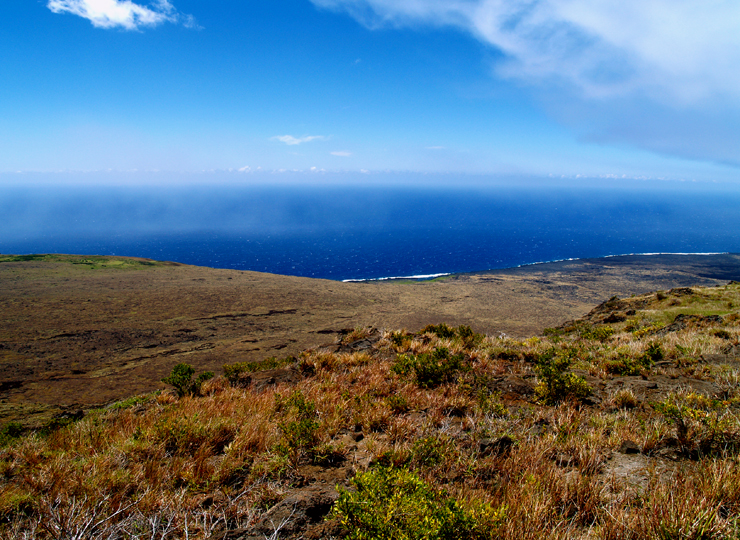
    But, we’re riding together and the scenery is beautiful, so we keep riding, eventually reaching a overlook of the Waipio valley. I walk carefully down a really step path in my cleats to reach the edge.


    This is a very crenelated section of coastline, with deep valleys that lead far back into the interior. There’s no easy access, though you can get down to the beach if you have a serious 4×4.


    I ran into these two ladies and they agreed to let me take their picture.


    After a few minutes there, we turn around and head back. We’re a bit slow because Sam’s getting her bike legs back. Somewhere in this section, one of the father & son pairs passes us, and a few minutes later, Sam says something like, “go chase them down and show them who’s in charge for me”.


    So, I put my head down and chased. It was… uncomfortable; my heartrate went from averaging 88 BPM before I chased to 150 BPM for the remaining 5 miles. It’s hot and humid and there’s a 300’ climb in it, but I’m decent at suffering so I hold on and arrive back at our start.


    Part of the reason I rode that way is that the longer option for the day was scrubbed due to some fallen logs from a recent storm, so I’d only be riding 20 miles for the day.


    Samantha rolls in about 10 minutes later, the benefit of a “bump”. A bump is where you stop before a tough part, they toss your bike on the van and then drive you to the top. This is a great way to extend your riding ability and annoy your father.


    Lunch is a typical backroads lunch; there’s some kind of meat (pulled pork IIRC), a few different salads, bread, some fruit (pineapple + mango), and various drinks. Their lunches have variety, it’s easy to find something healthy to eat, and the food is always tasty.


    After lunch, we pack into the vans to drive up the coast to ‘Akaka Falls State Park. It is, of course, hot and humid, but we walk on the walkway  – because that’s what one does – to reach the overlook.


    That’s 422’ of splendor. The walkway continues down so you can get a viewpoint of Kahuna falls, which, frankly isn’t worth the extra effort. But I did find this little feller on our walk out:


    We finished the day with a trip up from Hilo to Volcano Town.


    It’s a town! On a volcano!


    Okay, so, technically, every town in Hawaii is on a volcano, but this is up high – at about 3800’ – and very near to the Kilauea Visitor center. We are staying in the Kilauea Lodge & Restaurant – well, technically, we are pretty much taking it over; by my count we have 9 of 11 rooms occupied. The lodge was built as a YMCA camp back in 1938, and is rustic in a good way. There is no TV but there is internet.


    We have dinner that night in the restaurant. The apps are okay, but my Ahi is pretty tasteless. Probably the low point of our culinary experiences.

    Strava. 20.2 miles, 1128’ of climbing.


    Day 2: Volcano Day!


    This is a multi-sport day. After a hearty but slow breakfast at the restaurant in the lodge, we van up and head to the visitor’s center (technically, Hawai’i Volcanos National Park), where we meet up with Tim, our guide for the day. We first walk out to a viewpoint, where – if I’m remembering the geology correctly – we can see the whole caldera (the part that filled with lava at one time), and then, in the middle, the steaming crater.


    Perhaps this view will help:


    image


    You can see the edges of the caldera and the obvious crater. The previous picture is from the white buildings in the upper right. The caldera is about 2 miles by 1.5 miles


    To the right you see a small crater called Kilauea Iki, which means “little Kilauea”. Back in 1959, it was the site of a pretty spectacular eruption, with lava fountains reaching 600 meters (1800’ in freedom units) high. The crater filled with lava, which then drained back after the event. There’s some cool film of it here.


    We start with a climb down into the crater, which is mostly on a well-paved path, losing around 400’. We reach the floor:


    The hill to the right was formed from the lava fountain; it’s around 600’ high. The far edge of the caldera is about 1.5 miles away. In the distance, you can see a lake. A lake… of LAVA. Well, cooled lava, anyway. That’s where we’re going.


    Here’s a better view of the hill:


    I have helpfully inserted some people to give you a sense of scale. The lava here is pretty jumbled and sharp, which is pretty common for island lava.


    Here is a photo of the group:


    We make our way to one of the vent holes for the eruption (daughter provide for scale):


    At this point, we have reached the edge of the part where the caldera was full of molten lava. When the eruption finished , the lava cooled and the top few inches solidified. Then, a bunch of the lava beneath drained away, and when that happened, the top fractured as it dropped:


    Looks very much like torn-up asphalt roadway. We keep walking more, and we get to a section where the lava cooled differently, and the surface gets much smoother. We can see our vans parked up at the top of the caldera wall.


    As we reach the other end, we turn and look back:


    Then it’s a series of switchbacks up and out of the crater to the road, and then across the road to Thurston Lava Tube. It’s a tube in the ground, it’s okay, but not close to as impressive as the crater we were just in.


    Then it’s back in the vans to the lodge, where we have a nice lunch. And then, to the bikes! There are 3 options; a ride back into the park to a different overlook and back, a ride to the overlook and then down to a overlook of the ocean, and the ride down to the overlook and back. I would leave you in suspense as to which on I was planning on doing, but I think you will figure that out on your own.


    We ride off into a heavy mist, the remnants of Guillermo. I stick with the family on the way to the overlook, and as we leave to head towards the overlook, it starts to rain, at which point I remark, “I don’t know about you but I am experiencing *the hell* out of this national park”.


    We continue on as the weather switches back to on-and-off drizzle, which normally would be annoying, but since it’s 70 degrees it’s fine. We hit the turnoff to head down to the overlook, which is named Halina Pali. It’s a very minimal barely 1.5 lane road that winds up, down, and around the terrain the whole way down. It’s sort of a fun descent though you can’t get a lot of speed on it because you can’t see what’s ahead very well. We spend about 40 minutes on the 9.6 mile descent, and finally pull into the overlook, which looks like this:


    Theoretically. What we see is this:


    A quick picture of me, I refill my bottles, stuff my vest back in my jersey pocket, and head out on the climb back. I am not surprisingly the only one who thinks a 1600’ climb in the mist and rain is a great idea.


    In the first few minutes, I meet the remainder of the group who is riding down to the overlook. As soon as the group finishes wandering around and the bikes are loaded, they’re going to be heading back up.


    I have a goal. It’s to finish the climb from the overlook back to the highway before the vans make it out. 8.5 miles, and just over a thousand feet. I start climbing a little harder, it starts to lightly rain, which puts me in an absolutely perfect environment; it’s the first time I’ve felt cool and comfortable so I press a little harder. I don’t know the road and my GPS is hiding in my jersey pocket, so I’m not really sure how much climbing I have left. I hear a vehicle behind me a couple of times and expect it to be the van, but it is not. 47 minutes and 7 seconds later I hit the stop sign at the main road, turn left, and keep climbing.


    Another couple miles and another 300’ of up, and I reach another turnoff. Still no van. I turn up towards the lava tubes, the road kicks, up for the last section of the climb, and the vans finally pass me by. Five minutes or so later I top out on the climb. That’s 1640’ in 68:17, or a little under 1500’ per hour. Not bad, and I feel pretty good, good enough to head out the park and hammer back downhill to the lodge. I drop the bike off with our leaders and head in to shower and change.


    Stava: 37.9 miles and an even 2700’ of climbing, for a pretty good bit of riding. 


    Back in the van for a really short ride to Volcano Winery, where I discovered a couple of things. First, a lot of the wine there is far too sweet for my palate, and it’s not really a great idea to go to a wine tasting when you only had a small snack before your wine tasting. Luckily, we have moved to the more sweet wines and I’m really not very interested in drinking much of them, so I concentrate on the crackers on the side plate.


    After the winery part, we head to dinner at Thai Thai, an incongruously large Thai restaurant in Volcano town. The food is pretty good and the service is okay for a group of 19 people. I had a Thai basil stir fry with pork.


    Day 3: Volcano to Punalu’u Black Sand Beach


    This day looks like it’s going to be a lot of fun; we have a 3 mile climb and then we need to descend from 4000’ all the way back to the water. I love big mountain descents; a nice fast ride down is a great reward for the suffering on the way up. Or, in this case, the van trip up.

    We start the climb together and then I jump and start picking off the people who started earlier, and start to descend.

    And… it turns out that I’ve forgotten the basic topology of Hawaii. Hawaii is not an island with mountains on it. The island is a mountain – a very broad one – and 4000’ over 28 miles gives an average gradient of 1-2%. More of an “easing down” than a “descent”. I ride the section to the van stop, and then wait for Kim and Sam. We refill our bottles, and continue to head down, back into the heat. The route turns at Pahala, and after a short climb we hit a nice quiet agricultural road.


    After a couple of miles, we finish that section and I get in front to pull into the headwind for the rest of the way down to the park. We pull in, I pound down a Coke Zero from the cooler, and then we walk around a bit.

    Stava, 31.5 miles, 580’ of climbing, 16.8 mph

    Some of our party took this chance to catch a little sun. The sand is, indeed, black, which makes it pretty hot. I brought clothes in the van so I could change, and I do so in a pretty typical park bathroom (ie sketchy), but I don’t want to swim and then be wet for the lunch and the ride in the van, so I mostly sit in the shade.

    Kim keeps busy by taking 51 pictures of the beach, of the turtles, but mostly trying to catch the spray in the air. I like this one:


    After about an hour we van up and head to our lunch spot. Everybody is overjoyed to be in the air conditioning; it was pretty hot and sticky at the beach.


    We are lunching at Punalu’u bake shop, the southernmost bakery in the USA. As you can see by the sign.

    I don’t ordinary choose my sources of leavened comestibles by their geographical superlatives, but it is not my choice today, so we wind our way past a musician to a rather nice covered lanai set back a bit from the main building. There are two women in separate tables having a snack and reading, but they soon decide that maybe, just maybe, their experience will be enhanced if they move away from the 22 loud cyclists to one of the other seating areas.

    We had expressed our lunch preferences before we left in the morning, and they are (mostly) ready when we get there. IIRC, I had a somewhat average turkey sandwich on a really good bun, plus some pastry, plus some fruit. And I think I may have had a beer. The weather here is tolerable. After lunch, we van up and head out again.

    We have a long drive from where we are to Kailua-Kona. On the way, we are going to stop at Pu’uhonua O Honaunau, a historical place of refuge where lawbreakers and anybody else who wanted to stay out of a fight could claim refuge. Very much like making it to “home base” when playing “Hide and Seek”.

    The park is a recreation of what life was like in Hawaii in earlier times. How much earlier, I cannot tell you, because a) I left my park brochure in the car instead of carrying it around with me, and b) the NPS website refuses to return any useful information. From what I can gather, they built walls out of rock, buildings out of plant material, and fish ponds out of whatever one makes fish ponds of, but mostly they just hung out at the bar in the party pond and drank pina coladas to escape the oppressive heat and humidity.

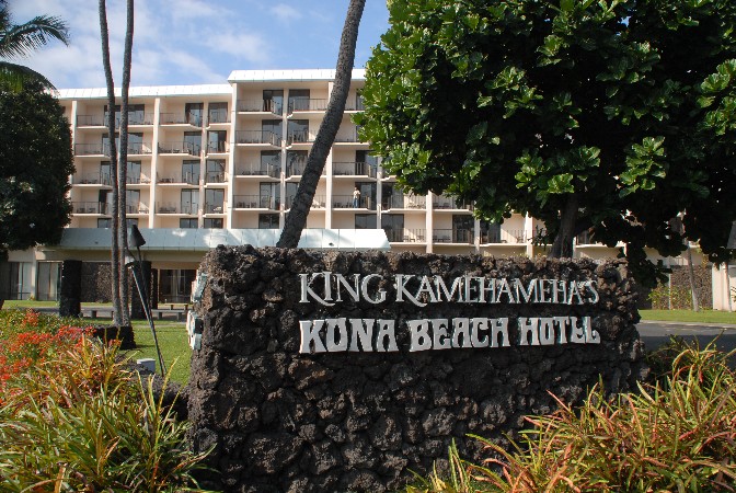
    We thankfully vanned up and continued on to into Kailua-Kona and our hotel:


    We hit the ABC store for some snacks and head up to our room. Kim and I have a view overlooking a roof that overlooks the small beach that the hotel has.

    In the afternoon, we have signed up for dugout canoe trip? session? experience? Something like that:

    We get the boat off the beach, get in, and head out of the little hotel harbor. We attempt to learn to paddle together as a team on one side of the boat, with limited success. We then learn how to paddle on alternate sides and how to switch our sides, also with limited success. Then we head back in, comfortable in the knowledge that, if circumstances ever put us in the seat of a competitive outrigger canoe race, we will be of little use whatsoever.

    That night is “dinner on your own”, and the Gunnersons head out on their own to a local brewpub.

    The service is good, and the food is good, but our enjoyable evening is interrupted by a gentleman – a gentleman named Guillermo, who has pushed some rain over to Kona. We move to another table, and, by the time we are done with our dinner, it has reduced to a light rain, the kind that Washingtonians such as us make a point of pride of walking in. The rest of the night is uneventful.

    Day 4: Water day!

    One of the reasons for travel is to expose you to new experiences, and you need to be paying attention or sometimes you may miss them. If you have your head buried in a book or are playing with your phone, you will miss out on natural wonders. This morning was one such instance; had I not been paying attention during breakfast, I would have missed seeing a young lady eat an entire dinner plate piled up with bacon – well in excess of 30 pieces by my estimation – followed by a dessert of fruit, bread, and another 10 pieces of bacon. I don’t think she weighed more than 100 pounds.

    Today will be spent on the water. We start by getting into our water togs and vanning up for a short trip to Keauhou Bay. We are going kayaking and snorkeling today. All the kayaks hold two people, so we have already decided that Sam and I will be in one kayak and Kim will ride with somebody else. She ends up paired with Jim, who’s family thoughtfully brought along an extra child since Kim and I had the poor foresight to only have the one.

    We have gone sea kayaking a few times in Puget Sound (and once in Alaska IIRC). The water there is cold, so you need a stable kayak that can keep you dry. One like this:


    But, we’re kayaking in an area with warm water, so we end up with a kayak like this.

    We are going to be snorkeling and swimming off of the kayaks, so our leaders give us a quick demonstration on how to get out of the kayak smoothly, and then how to get back into it. Getting out is all about the proper points of contact so you don’t rock the boat too much, and getting in is about swimming out and then rolling into the seat. Our leaders do this about as well as you would expect someone who does it a few thousand times a year.

    We all have life jackets, though Sam and I have them deployed behind us to give us a little extra cushion. Sam has done a lot of swimming and loves the water, I suffered through lessons and a few years of swim team, and Kim grew up swimming in the surf in Key West so the hard part is getting her out of the water.

    We launch from the dock and row out to a buoy in the bay to assemble the group before we head out. Kim and Jim decide that they want to practice the exit and entry procedure for the kayak; they do fine getting back into the boat but did not exit it in the approved manner.

    And, it’s time to paddle. Sam is nice and consistent, and we settle into a steady rhythm. Except that the boat is consistently pulling to one side, so we have to paddle asymmetrically to get it back in line every minute or so. Unlike sea kayaks, these guys don’t have a rudder you can use to keep you on course, so it’s paddle for a couple of minutes, turn, paddle for a few more minutes, turn. With 9 boats doing this, it’s a bit of a comedy going out. We pause to regroup now and then. Along the way we run into a pod of dolphins – spinners, I believe – that cavort through our assemblage of boats.

    Kim is having a horrible time:

    Eventually, we reach our destination a bit down the coast. I believe it was near Kualunai point. The leaders anchor their kayaks and we all tie up to them, and then we get out to go snorkeling. I have my old Canon A20 in a waterproof housing (actually, it’s not my old camera – it’s my slightly-less-old camera since the old one suicided while snorkeling the last time we were in Maui), and Kim has her brand new Nikon waterproof Coolpix.

    We swim around a bit. I do a few dives, but we are not equipped with fins, so I can’t get down more than about 10 or 15 feet or so, and to do so I thrash around enough that the fish just swim away. The snorkel is the old school kind (no valve), but that’s what I learned on so I’m okay. The mask, at least, is high quality; no leaks, and easy to equalize pressure in.

    I had planned on showing some decent underwater shots here, but they’re mostly pretty bad, so I’m going to spare you the details.

    After 30 minutes or so of swimming and diving, we group back at the boats to have some snax and cull the weak from the strong. You can see the weak up there.

    I would, of course, have participated in this activity except that I’m wearing my contacts and would probably lose them. There could be no other reason I would avoid climbing a precipitous rock face and hurtling myself out into the void over some hard-looking water.

    The young one does it:

    The we circle the wagons, get everybody back in the canoes, and head back. This turns into a little bit of a race, which is fine, except that the boat keeps yawing to the port side (yeah, I’m gettin’ all nautical and stuff), so we have to stop paddling on the right pretty often. My left arm is significantly sorer at the end.

    We eventually make it back near the dock, get careful instructions from our leaders about how to queue up so that we can get the kayaks out smoothly, which are then promptly forgotten by the majority of the boats as they rush for the ramp.

    We finally disembark, grab our stuff, and head to rinse off in the outdoor shower. Nice to get the salt water off, a bit bracing as far as the temperature goes. Another quick change into normal clothes in another somewhat dodgy park restroom, and we head off to lunch.

    Which is at Akule Supply, conveniently located a mere 25 steps away.

    After the paddle and the swim I probably would have even eaten poi, but the food is good. IIRC, we had:

    • French fries
    • Deep-fried avocado with spicy sauce
    • Chicken something
    • Salad something something

    I grab a Diet Coke from the cooler, and we sit around and talk until it’s time to go. We van a bit until we get to Kona Blue Sky Coffee.

    At the plantation, we get to sample the different blends and learn more about how coffee is harvested, processed, and roasted. As a non-coffee-drinker, I am not paying a lot of attention, but I gather that there are elves involved.

    We have another transit to do, this time to the Fairmont Orchid, so it’s back in the vans again, and we head out to the Fairmont, where we check in and chill until it’s time for dinner.

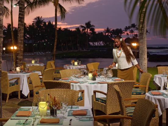
    Dinner is at the Mauna Lani hotel just down the road a bit and their CanoeHouse (apparently spaces are rationed on this part of the island).

    They have a large canoe hanging in the rafters so that you know that you are in the right place. I decide to skip the fish for a nice and have the rack of lamb; it is excellently presented, cooked to perfection, and utterly devoid of seasoning.

    There is a bit of a pattern here – if you are in a resort, the food isn’t very good, and if you are outside the resort, the food is generally better.

    But, it is a good night with good company.

    Day 5: Waimea – Polulu Valley Lookout

    This is the last day of riding. There are three different routes listed – a 9 (ish) mile route from the drop-off point to the lookout, an 18 mile route to the overlook and back, and then a 33-mile route out to the lookout and then back to Kawaihae for lunch.

    The night before, the leaders offered the group the opportunity to ride from the hotel to the dropoff point, an extra 29 miles at the start of the day. I am the only one who raises my hand, and this means that I’ll be heading out at 7:30 in the morning. I get up early and put on my bike stuff and a lot of sunscreen, to try to avoid making my sunburn worse. A quick and light breakfast at the buffet (seems a waste to have a light breakfast at a big hotel buffet), and I meet Rob in the lobby, and we take a bit of a trek through the parking lot with me in my socks to where the van is parked. My bike is out and ready; I have decided to skip the tail trunk today because I expect it to be windy and I don’t want the extra drag.

    I spin out of the hotel and turn left on Queen Ha’ahumanu Highway. The course that I am riding is part of the Kona ironman course, and I’m riding the last 29 miles to the turnaround point. As I get up to the next hotel, a couple of riders pull out in front of me. I’m sure one of them is a triathlete; he has aero bars and a water-bottle holder on the back of his seat. The second guy has a normal road bike. They are just getting started, so I pass them by and pick up my pace a little. The road is through lava fields, but it’s still pretty early and the weather is cool, so it’s okay. There is a slight sidewind coming down from the mountain.

    At Waikui, I turn left onto Akone Pule HIghway, and the wind is now behind me. Unfortunately, there is a descent as well. That probably sounds like a weird thing to say, but that means that the descent won’t last long. Two minutes later, I’m back down by the water.

    The cue sheet for this section, and I looked at the map the night before. It’s pretty straightforward except for when I get into Kawaihae, where it say “don’t take the turn to the Marina”.

    I take the turn to the Marina.

    I figure it out fairly quickly, and get back on the right road. During this excursion, the two riders that were behind me pass ahead. I slot in behind them and we keep riding. At the first hill, the second rider drops back, and I start talking with the first guy. He’s out training for a half-ironman that is coming up later this year. He warns me that the upcoming section is going to have some nasty sidewinds, and that there is a 4 mile climb up to Hawi. We ride together for a while, and then he stops to wait for his friend.

    And wow, he was not kidding about the sidewinds. At times, the road is shielded by a hill cut, and then you come out to get hit by the sidewind. 20MPH is my guess. I ride for 10 miles over a bunch of rollers, and hit the base of the hill. I start up.

    As a hill, it’s not very steep – my GPS says it’s only a couple of percent in inclination. But – and this is a big but – I’ve turned to the right, so the sidewind has turned into a headwind. It’s a nasty one. But, I know how to suffer, so I just keep climbing. At least the wind is keeping me cool. The view to the left is pretty nice, but it’s easy to get jaded after a week in Hawaii. After ten or fifteen minutes, the triathlete shows up and tell me his friend turned around, and he will be turning around in a little bit. He powers on ahead, and quickly pulls a U-turn to head back. At this point, the vans pass me.

    The road has curved a bit more to the right, and now I’m headed directly into the wind. I climb, climb, and climb some more, and then finally top out in Hawi. The climb was about 5 miles, and only climbed about 500 feet.

    I reach the vans just as everybody is getting ready to roll out. I refill my bottles and head out with the wife and offspring. My plan is to ride with them to the overlook, and then we’ll decide what to do from there. I get in the front to block the wind. The first section is mostly downhill, with a few intense uphill sections (one was a nice 20% grade). We keep riding until we get to the Pololu Valley Lookout, which is the same valley we looked at from the other side on the first day. We go and look – ho hum, another incredible view – and I stuff my face with some Maui onion potato chips to get some more salt into my system.

    We turn around, Samantha decides to van back (or at least part of the way back), and Kim and I decide to ride back. Lara is going to ride with us.

    As the morning has gone on, it’s gotten warmer and a bit more humid. It’s easier to ride with the headwind than the tailwind, but we have pretty much lost our cooling wind, so it’s getting a bit miserable. It takes us about 75 minutes to ride back to the drop-off point, which involves about 600’ of climbing. We are the back of the train right now, so we re-water and re-fuel and press on. We have 17 miles until lunch.

    The first 5 miles – back down the hill – are great, kicking along at 25 MPH. That lasts about 15 minutes, and then it’s back to the rollers I rode through earlier, except this time the sidewind is mostly gone. It’s not too bad when we are out in the open, but when we get in the road cuts, the rocks (aka “lava”) are radiating heat, and it’s about 20 degrees hotter in those sections. After two water stops and about 300 hours more of riding, we get to Kohala Burger & Taco. I am well and truly cooked, but thankfully Kim says that she is done, so I don’t have to ride back to the hotel.

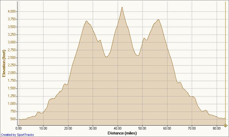
    Strava, 62.8 miles, 4050’.


    Pretty much everybody else has their food or is already done, so we head inside to place our order and cool off a bit. I drink two cups of ice water while we wait and then shotgun down a Diet Pepsi. Our tacos show up, and as we are sitting there eating, the first van loads up and heads back to the hotel. We finish our food (fish tacos, quite good, though my culinary requirements after that long on the bike are possibly a bit suspect), and Kim gets in line to get some shave ice. She finally gets to the front of the line, gets her ice, and we get into the delightfully cool van to head back to the hotel.

    There’s a certain feeling after a hard ride when you get some real food in you, and we are feeling okay. As we pull out of Kawaihae, we notice some smoke to the right of us, which quickly resolves into a major brush fire.

    The road that I rode from the hotel is closed and, as we watch, a bunch of emergency vehicles flee that area to come back towards us. We aren’t going to be able to get through on the road. But we have drinks and snax, so we’re fine. We head back the way we came and turn into a private gated development that climbs up the hill about 4000’. Then we turn and head towards Waimea, back south, and then – finally, back to the west and our hotel. That’s about 50 miles of driving to go 10 miles, but we didn’t have big plans for the afternoon and we had a great group in the car, so it was fun.

    After removing 62 miles of volcanic grit off of my body, we get ready for our last dinner. We started with a reception at the bar near the pool. It is very strange to be having drinks with your daughter. And then we headed over to Brown’s Beach House Restaurant for our last dinner together.

    We had pretty much that exact view, on an out-of-the-way section of the seating area. Which was nice. After a bit, the appetizers came – I had some of the beef cheeks, which sounds like a great way to convert a cheap ingredient to a $18 appetizers. I ordered the Big Eye Tuna, a bit of specificity that I assure you will become important soon.

    And then we talked. Either we didn’t look very hungry or they lost us, but we waited a very long time for our food to show up. And then they showed up with the plates but didn’t know who had ordered what, which isn’t great if you’re charging $40 a plate. Mine came back as “Ahi”, which is technically correct but more than a little confusing when there’s a server walking around asking who had the ahi.

    By this time, the restaurant was empty, but we did have time for dessert before we headed for dinner. I’m actually a little tired of appetizers + entrée + dessert at dinner and am hoping for something simpler in the near future.

    Day 6: Petroglyphs

    This morning includes an optional historic activity, but the brush fires still have the road closed, so those of us who are left take a short hike to some nearby petroglyphs. It’s a nice trek over a golf course, along the beach, through a parking lot, and then back through a whole bunch of scrub forest.

    When you get there, the petroglyphs do not look at all like these, which are recreations right next to the parking lot.

    They look like this:

    Then it was back to the hotel and into the van to head back to our original hotel, where we hung out, went to a food court for dinner, and watched the sunset. And then got up the next day and flew home.


    Sufferin’ Summits Hill #8: Somerset & Traverse

    Highland/Somerset <= Somerset & Traverse => (mostly) down to the finish!

    Breaking news!

    For many years, I thought that “Somerset” meant climbing up the road we just descended, because that was the only route I had ridden. At about 450’ and a nice section of about 16%, this is certainly a challenge. And then, one day, I was looking at maps (because I lead a Tue/Thu night ride and like new routes), and I realized that there was a route from the west that I had never heard about that starts a bit lower down.

    So, I went and rode it, and found out why I had never heard about it.

    The route is mostly easy to follow, though there are a couple of places where you need to pay attention. Start up the first pitch, and when the road ends, turn right. Take the first left and continue climbing, following the road as it curves around. After the big curve, you are looking for the first turn to the left – 136th Pl NE. If you miss it and you run into Highlands drive, turn around and come back.

    After the turn, there is about a half mile section that will end at Somerset Blvd – the one we descended down earlier. We turn right, then right again on 139th Ave, and a final left on SE 47th. This section is easy to navigate; just keep turning on the streets that go up. At the top, turn around, and enjoy the last great view of the ride.  We don’t have the altitude we had at the earlier climbs, but we are closer in and there is nothing in front to block our view.

    Image result for view from top of somerset bellevue

    image

    Now, it’s time to traverse to the east towards the finish.

    We descend back down to Somerset Blvd and turn right. The first pitch is a steep descent with a stop sign at the bottom. Turn right, and then take the first left on SE 49th. Continue straight until it ends at 151st Avenue, which we travelled earlier on the Summit climbs. Turn left and take the first right on SE 48th. This will curve around and change names a couple of times, and finally end at 159th Pl SE.

    Turn left, and then take the first right on SE 48th drive. This will take you to a short bike/ped section and then a steep descent down to 164th with the usual stop sign at the bottom. Turn left on 164th, descend down to Newport, and turn right. This will take you all the back to the starting line.

    4.6 miles, 861’

    image


    Sufferin’ Summits: Hill #7–Highland/Somerset

    #6 Summit North <= Highland/Somerset => #8 Somerset and Traverse

    This section is mostly a portage from our last descent to where we will start section #8, but there is no reason that a portage can’t be “fun”.

    After turning right at the bottom of the summit descent and then right at the next stop sign, we find ourselves back on Forest Drive. After just over half a mile, we turn right on Highland Drive. This climb goes steep/flat/steep/downhill/steep/flat, and will take us into a notch between Somerset hill to the west and Summit to the east. After a short 1/4 mile rest, we turn left on Somerset Blvd, hit the crest, and then continue down to the North. Nice views here, but at 15-16% you will be needing to use your brakes.

    We eventually come to an exit where you can see a traffic light to the left. Turn left to the light, and then turn left to get onto Newport Way. Once again, we have a descent that we are going to be turning off of, so watch your speed. After half a mile on Newport, the road will curve right but we turn left on 130th Place SE, then left on 130th Ave SE. Continue straight on this road; you’ll know when you’ve reached the start of the next hill.

    3.9 miles, 359’ of climbing

    image

    image


    Sufferin’ Summits Hill #6 – The Summit Strikes Back: from the north

    #5 Summit South <= #6 Summit North => #7 Highland/Somerset

    *************************************

    Note: I hadn’t ridden the section on Squak for a while when I wrote it. I rode it last weekend and re-wrote that section. You should go read it now so that you understand what the descent is going to be like and don’t ride your bike off the road.

    *************************************

    After the nice descent down from Summit and replenishing our food and water supplies, we’re going head west and do something a little different and easier.

    Ha ha! I make joke! We’re actually going to climb right back up the hill that we just came down. This is a climb I do fairly often; it’s near my house, the roads are good, traffic is light, and there’s a surprising amount of up. And there are a few different routes to take.

    We, of course, are going to take the hardest way up. It’s a bit convoluted, so you’ll need to pay attention.

    Starting way down near the water, we turn right on East Lake Sammamish, and then turn right into the Forty-One Point Five development. Follow the road as it turns right and then – you guessed it – starts going up steeply. After a couple of left turns, it will top out. As the road turns left, look for a path on the right; I *highly* suggest getting off your bike and walking it as there’s a tight turn and it can be mossy. Turn left on the path and descend down to the bridge, and ride over it the other side, and turn right on Newport Way.

    After a easy 1.2 mile climb – enjoy it because it’s pretty much the only one all day – the road flattens, and we turn left on 155th Pl SE. Just look for the very steep hill. Follow the road as it winds up; when it flattens, turn left, and when it flattens again, turn right. When the road ends at SE 46th, we turn right. That road ends on 150th, where we turn left and climb up on the road we descended recently. Keep climbing until you reach the park:

    IMG_6913

    and then follow the road to the left. Take the first left, and that road will lead you back to the gate you climbed over earlier.

    IMG_6916

    Cross it again. Turn right when you hit the main road, work your way around, and descend down the south side. Watch your speed as there is a stop sign at the bottom.

    Turn right at the bottom, and follow the road down until you hit Forest Drive.

    It isn’t the most continuous climb around, but this section nets us 1100’ over 5.9 miles. That is our 4th climb over 1000’ in elevation gain.

    Route and climb info. Click to view.

    image


    image