Browsing posts in: Bicycling

RAMROD 2013 Ride Report

This year marks the fourth time that I have gotten up far too early, journeyed to Enumclaw, and hauled my body around the mountain (to be fair, in 2007, road closures meant that I hauled my body back and forth along the east side of the mountain). Perhaps it is true that as one gets older, one loses the capability to learn.

The event has not been particularly kind to me. A lesser man might blame the tides of fate, the sands of time, the grapes of wrath, or the whims of mother nature. I do not. The problem is my simple lack of willingness to train properly for the event. I’m only willing to devote about 8 hours/week to training during the season, and that hasn’t really been enough to thrive on the ride. I also have had some bad luck. If you want the the details, you can find them here, here, and here

This year, I decided to try something different. I bought a copy of Carmichael’s, “The Time-Crunched Cyclist”, went out and did a field test (always a fun way to spend 20 minutes), and started making up a training schedule. This was a bit challenging, since I lead a ride for Cascade Bicycle Club two evenings a week, and I have to figure out how to fit the workouts into the rides. This hasn’t always worked, but I can say that the loads of time I’ve spent on the intervals has made it much more comfortable to ride at my aerobic threshold than before; my legs are hurting but I’m not out of breath. When I get a bit of rest, I’ll redo my field test and write a more in-depth report.

This is also my first year “training with power”, since I picked up a Powertap hub last December. I expect to lean on it heavily to ride at a reasonable speed on the climbs.

I’ve also cut out some snacking at work and at home. Back in April, I saw 181.6 on the scale, and the morning before the ride, the scale ticked back from 170.0 to 169.8. Bike + Eric is now about 6% lighter.

My big goal on the ride is to get my nutrition better. I’ve been okay on hydration – working through a bottle of my Accelerade-based drink and a bottle of Nuun over two hours or so – but I have not been eating enough. So, I’ll be trying to eat more.

As for the ride, I plan on riding easy for the first 60 miles, riding a bit harder but conservatively up the Paradise climb, and then – assuming I’m feeling good – pushing the pace up Cayuse.

Prequel: The crisis

After leading an Eastside Tours group ride two weeks before the ride, I come home with a slight cough, which worsens over the weekend. It’s not horrible during the day, but I’m spending the nights on the couch in the basement trying stop coughing, generally for 3 hours or so.

The next week I’m in training at work, so I can’t get to the doctor, so to make sure I don’t get sicker, I find somebody else to lead on the evening rides that week. Not really… what I actually do is lead the rides, cough deeply whenever we stop, and ask the other riders to help out because I can’t talk in a loud enough voice to give directions. I finally get to the doctor on Friday – he interviews me, tells me that he’s seen some “really strange symptoms” recently, and hooks me up with a five-day course of Azythromycin and a bottle of old-school cough syrup (you know what I’m talkin’ ‘bout). This wasn’t the kind of taper I was planning to do, but I’m stuck with it, and the antibiotics do help after a couple of days. I’m not coughing my lungs up any more, but I’m a bit tired and I have a weird tightness in my right IT band near the hip, presumably from the nights “sleeping” on the couch…

Episode I: Preparation and Exploration

I get up at 3AM, eat a small bowl of cereal, get dressed, and hit the road. I arrive in Enumclaw about 10 minutes before the start, pull the bike out of the car, and do a weather check. Despite wearing my rails to trails jersey – which has lots of pocket space – I have a lot of stuff to put in it, and anything I wear in the morning I have to carry the rest of the day. My hope was to just get by with arm warmers, but 90 seconds of exposure tells me it’s a very cold 58 degrees, so the vest goes on as well. I head over to the starting line, take a quick nature break, and roll to the start line. The volunteers pull my starting tag (the track riders around the course), and I head off into the predawn, turning on my flashing LED front light. The time is 5:08.

According to reputable sources, the word “Enumclaw” translates to “place of evil spirits” in the language of the Salish Native Americans. In the gradually lightening skies, that does not seem too far-fetched.

I roll out into the darkness, a bit apprehensive of what is to come. A week of gentle tapering and illness have left me with quads that hurt, an unsettled stomach, and a sort IT band. After a few minutes, I turn left into Buckley, almost miss the same right turn I almost missed last time, and am quickly passed by a group of four. I generally like to warm up a bit before I latch onto a group, but I have a new source of information – my power meter. I hook on and find out that I can easily hang with the group at 110 watts, which is pretty easy, so I stay with them. I am expecting to roll through the group to take a turn on the front, but the guy in front isn’t budging, so I settle in at the back. We ride for about 30 minutes, hit the low point of the ride, and head left on Orville road.

At this point, the workers in the group pull off for a “nature break”. Being the first person left – and therefore the defactor leader of the remaining group – I keep riding but at a reduced pace since we’re no longer descending. I reach into my bento box and pull out a Honey Stinger Chocolate Waffle.

I bought these because they have a picture of Lance on them, and I’m hoping that they contain some of the “special ingredients” that Lance used to get from Dr. Ferrari. After a little bit, we hit some slight hills and the group breaks apart. I end following a guy with aero bars and a very creaky drivetrain. This is one of my favorite parts of the ride; on the left we can see the waters of lake Kapowsin with an early morning mist rising off of them. A group of 3 riders slowly passes us, and I notice that the last rider in the group has a very special number attached to his jersey.

RAMROD has this interesting tradition – it assigns jersey numbers by the age of the rider, with the oldest riders getting the lowest numbers. The rider who has passed me is wearing the single-digit number “1” on his jersey, and – if I recall the history of RAMROD correctly – is in the early stages of his 30th ride. After a while, he tires of the pace, and goes to the front of our group to pull for 5 minutes. He pulls off, and I’m now second-wheel to a woman in a team kit. She pulls for a couple of minutes, I prepare for my turn at the front, and in a bit of exquisite timing on my part, we hit highway 161 and turn left. This is the first real hill of the course, a short 280’ climb up into Eatonville. I make my usual “nobody told me there would be hills on this ride” joke, and she laughs. We roll into the first food stop.

I park the bike, take a nature break, eat a small blueberry scone, and then refill my bottles. I’ve pretty much hit my nutrition plan; I went through both bottles and had a waffle and some triscuits. As I’m heading out, I run into my friend Alan who has just gotten in; he left 20 minutes after I did but was riding with a group that was much faster. This will be a recurring – and expected – theme for me today. I spent 12 minutes at the stop.

The next section is 25 miles and we will climb up about 1300’ during the section. It starts with a few hills, a slight descent, and then a slow climb in the 2-3% range. I end up pulling a group at perhaps 175 watts; this is a little more than I wanted to be doing, but I keep doing it. I do eat some more, but I don’t drink as much as I should. My stomach is still feeling unsettled, and every once in a while rises above that to reach the “nauseous” level. My legs also still feel weird. This is a really pretty part of the ride, and I spend quite a bit of time looking at the scenery and chatting with the rider behind me. Pretty soon, we reach the Wildwood food stop, at 58 miles in.

It’s old home week at the rest stop; I talk with Alan, Francis, Mark, Lizza, Daniel, Laurie, and a few others who I can’t place (being a ride leader means that that I have a lot of asymmetrical acquaintances, where somebody knows me (and knows my name) better than I know them. It’s a little weird and embarrassing at first, but I’ve run into this in the past in some work-related settings). Two people thank me for my RAMROD 101 post. I do not feel as good as I had hoped, in fact, I don’t feel very good at all, but there is nothing to do but keep riding. Time off the bike = 12 minutes.

Episode II – The Test

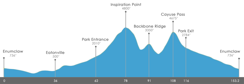
I head out from the stop, and very soon, the route enters the national park. At the entrance, they have a lane for us (we have already paid for park entrance as part of our fee). There are volunteers out to record rider numbers, so they know where to look for riders if they don’t show up (this is a significant concern; with fast-ish alpine descents and not-so-great road conditions, there are incidents, and last year a rider went off the road on one of them and ended up dying, so it’s important that they know where to look for missing riders). I don’t put a number on my bike because it gets in the way and flaps around on the faster sections, I don’t put it on my helmet because it looks stupid, but I do have my number on my back. One of the volunteers repeatedly yells “what is your number! I need your number!”. Well, first of all, all that I know right now is that my number is in the 400s, second of all, they shouldn’t listen to what I say because I might have it wrong, and thirdly, I can’t talk loudly because my throat is bothering me.  If I was in a group I would have stopped to make sure, but since I’m all alone I figure that can read it from my back and I just roll through. I then roll through the RFID reader that they’re trying out this year, and I’m on the way up. The entrance to the park is at 1800’, and we’re going to top out at a little over 4800’, so we’re talking a 3000’ climb in the next 19.5 miles.

The first section of the road is about 10 miles, and has us winding through the woods and up to Longmire on a 2-3% grade. The forest canopy totally covers us, and there isn’t much traffic, so it is very peaceful. I settle for climbing at about 175 watts at a cadence of about 90; I’m a stronger climber at 80 RPM but I’m a bit concerned that I can’t push that for the rest of the day. My heart rate is about 130, which is in the meat of my range, but this feels harder than I had hoped; I think the time off and the sickness are coming back to get me. We pass through Longmire, and the grade stiffens a bit, into the 4-5% range. I stop for a minute to stretch and rearrange my food for better access. I’m probably not drinking as much as I should here. I’ve passed a few people so far, and been passed by a lot more – this is also expected. At one point, as I pass a triathlete I’ve been slowly catching for a while (the bottle holders on the back of the seat are a giveaway), I say hello, and he says, “How are you doing today?” That’s a little chatty for this sort of climb, so I take a closer look, and it’s Paul, a friend of mine. Paul is a serious triathlete – Ironmans (Ironmen?), marathons, that sort of thing – which either means I’m climbing pretty well, or he’s slow. It turns out that it’s a little of both; he hasn’t been doing as much riding as usual. I drop my pace to ride with him, and we chat as we keep climbing, which is hugely useful to me – this climb keeps going and going, and I’m keep thinking we’re near the top, only to get disappointed. We pull into a water stop, which surprises me, as the traditional water stop is at the top of the climb. I spend 7 minutes there; just long enough to refill my bottles and talk to Laurie and a few other cyclists a bit. There are two ways out of the parking lot; you can go back to where you came in and continue the climb, or you can head straight. Straight seems shorter – and it is – but what I fail to notice is that the parking lot is flat, so I have a nice 10% climb to get back to the road. Thankfully, it only takes 5 minutes to dispatch the rest of the climb, and then we are greeted by a nice section of gravel road – the reason for the water stop being lower on the climb – which is a bit of joy. It’s okay except for the one point where I hit a section of deep gravel and the bike has a different idea about direction than I do, but I roll through.

Climb stats (from Strava)

Distance: 19.4 miles
Elevation Gain: 3012’
Time: 2:02:07
Average speed: 9.5 MPH
Power: 167 watts
HR: 133 BPM

I know I wasn’t doing great on the climb and not feeling well, so I’m okay with that. It’s a PR for me only because my previous trip up was an angst-ridden slice of not-fun.

I take a picture (which comes out pretty nice for a phone), and head out to the Stevens Canyon descent. This is generally a fun descent; the grade is a fairly steady 5%, and it will take me from 4800’ down to about 3000’ in about 13 minutes; a bit faster than the way up. I would normally lightly pedal this out to keep my legs warm, but for some reason the upper right part of my right calf (near the IT band) is hurting quite a bit, and I decide to rest and coast. That doesn’t work very well either – it hurts just as much. So, I HTFU, and try to bear it on the way down. That takes me to the Upper box Canyon food stop. I grab a cookie, have some potatoes with seasoned salt (but perhaps too much salt…), and refill my bottles. I know that NSAIDS and exercise don’t really go well together, but the pain in my leg has me concerned, so I take a couple of ibuprofen and head out riding with Laurie. Elapsed stop time, 13 minutes.

Episode III – Dehydration and Disillusion

We descend another 200’, and then start the backbone ridge climb. The 2.3 mile, 563’ climb is dispatched in a hair over 19 minutes at 171 watts. I reach the top quicker than I expect, and run into one of my riding group logging rider numbers. As I head over towards the descent, one of the volunteers tells me that this crappy, torn-up, borderline-unsafe road is newly paved. The 1100’ descent is glorious; the pavement is perfect, and the 20 MPH curves that used to be torn up and bumpy are smooth and easy. The only thing that would make it better is if I felt better, but even so, it is over too soon.

Which brings us, finally, to Cayuse Pass. I ride the first 3 miles – a bit of a preamble – and then I’m in the meat of the climb. 8.8 miles, 2500’ of climbing, but at a 6% grade, steeper than Paradise was. Status check: I’m hot, I’m dehydrated, and I don’t feel very good. Mood=cranky, which is normal for Cayuse, but makes 90 minutes of climbing seem daunting.

So, I take the climb a little bit at a time. I’m riding at 6MPH at around 170 watts, which means it takes 10 minutes to climb a mile. I ride a mile, stop to drink and rearrange my food and have a little snack, ride a mile, spot an empty patch of shade desperately in need of an occupant, etc. As I climb, I’m listening for a very specific sound – the sound of falling water. When I hear it and feel a cool breeze, I pull off to the side, set my bike carefully into the ditch, take off my helmet, and carefully go on a short hike over to the waterfall (If you haven’t tried to hike over loose rock wearing cycling shoes with cleats on the bottom, give it a try). To reach the water requires me to basically stand in the stream, so I get wet feet, and then I reach down, grab handfuls of water, and throw them onto my head, my front, my back. The water tastes salty because I am pretty salt-encrusted at this point, but it makes me so feel so much better. Back on the bike, and back to the same scheme – climb a mile, take a break, climb a mile. The cooling effect from the waterfall water lasts about 20 minutes, then I start getting hot again. I am not the only one taking these short breaks, where we get to admire the scenery, and the others slogging their way up. We are little islands of suffering, each emptying a personal basket of pain, coming together and drifting apart.

Several days later, I reach the water stop, where I toss my accelerade and refill one bottle with water so I can pour it on myself in the future. I sit down and stretch for a minute. I run into ex-Eastside Tours ride leader Dan, and we chat for a bit. On the way out, I say, “only 3 miles, right?”, and he replies, “4 miles”…

Drat.

Back on the bike, but the grade drops down to 5%, and the combination of that with pouring water on me allows me to ride a whole 23 minutes without a break. Then 15 minutes, then one final push, and I finally come to the highway 410 junction sign, and I roll into the water stop. A very quick stop, and I roll out down towards the deli stop.

I’m hot, tired, cranky, and as soon as I start heading down, my leg hurts again. But, 12 minutes at 30 MPH and 8 minutes at 20 MPH takes me to the deli stop.

The deli stop features custom sandwiches, and is one of the nice things that make RAMROD different. But… and there is a big but… the deli stop sometimes works well, and sometimes doesn’t. In this case there is a long line in the sun, and it’s moving slowly. I grab my nuun and try to rehydrate as I wait for my turn. The problem is easily apparent; you have to wait for the person to get your bread, then you have to wait for the next person to put mustard on it, then you wait for your meat, then for your cheese, and finally for your tomato and lettuce. This is the kind of thing that drives me crazy; a little optimization would easily double the throughput and get rid of the line. Then there’s a volunteer in charge of chips doing nothing because she already has 50 servings ready. I open the coolers to grab a drink, find one is full of juice, and the other has 8 cans of Coke. I can’t drink the coke because fructose doesn’t sit well with me, so I look around, spy a bunchy of diet coke in the refer truck, and tell a nearby volunteer that the there is no diet coke in the coolers. She pulls out one can, hands it to me, and goes back to what she was doing.

Drives. Me. Crazy.

Finally provisioned with food, I score a chair near the amateur radio setup (no cell phones for most of this core so local amateur radio “hams” do communication for the ride), eat my sandwich, chips, drink my pop, and try to recuperate. The deli stop is always a place of bittersweet feelings; no matter how you feel about your performance so far, you have survived it, and the hardest work of the day is done. On the other hand, you have 36 miles to go, and it’s hot, and there’s always a headwind.

Episode IV – A New Hope

After 60 minutes off the bike, I pull the bike off the rack, roll back out onto 410 and head towards the finish. This is a nice section; it’s pretty consistently downhill for about 17 miles, and – unlike the big hills of earlier – this section is more about power/drag ratio and less about power/weight ratio, which is a better fit for me. I’m cruising along, making okay time, hoping that a nice group will pass me and I can hop on. For the first 9 miles or so, I have no luck; I pass 6 or 7 tired souls, but none of them look able to ride the pace I’m currently at, and nobody passes me. I start to get depressed; the flats in the last 20 miles are going to uncomfortable if I am alone.

Then, I hear a bell next to me, and a group passes me. They are going a bit faster than I would like, but, as the old say goes, “coming down the 410, wheel-suckers can’t be choosers”, so I jump and get on the back of the group. Normally, just jumping on without asking would be a breach of etiquette, but it’s pretty much expected on this section of the ride. There are three of them; two of them wearing Speedy Reedy team kit, and another one (friend?) in blue. We’re heading down at 24-26 MPH, which wouldn’t be very impressive on a downhill, but the headwind today is pretty intense. The guy in blue is in front; he peels off, as he drifts back, I tell him “one more on the back”, and he slots in behind me. I tag the guy in the front “Puller”, because he’s working hard and doing a nice job; very predictable pace, and it’s easy to sit behind him. He pulls for perhaps 7 minutes – a long time in this wind – and pulls off. His teammate immediately jumps the pace up 2 MPH (rookie mistake), and I pull up close behind him to prepare for my turn at the front. Four minutes pass, and he’s starting to tire out and slow down, but he stays out there. Another minute goes by, Puller pulls out, rides forward next to teammate, pats him on the back, and they exchange a few words. Puller drifts back, ding’s his bell, and his teammate (who is now tagged “Trainee”) pulls off, and I’m on the front.

The wind is honking bad; I take a quick look at my power meter, and see that I’m at about 250 watts, which is okay for the two-minute pull I have in mind. I concentrate on being smooth and predictable. Riding smoothly has been a goal for me for quite some time, and two years of being in front of groups rides on the flats have improved my skills, so – if I do say so myself – I’m pretty good at this. Looking at your GPS to figure out how much time has passed is a bad idea at the front of a fast paceline, so I count revolutions of my pedals. When I get to 180, I check my mirrors, look over my shoulders, and pull off the the left. As I drift back, I get a “good job” from Puller, and I settle into the back, rehydrate, and wait for my next pull. “Blue” spends about two minutes before he drifts back, which makes me happy – he’s about at my level – and we continue the rotation. On the first half, because of the descent and the headwind, I’m only using 100 watts to stay in the pack, but 250 out front, which is a huge difference (and the reason I really wanted a group for this section). After what seems like a very short time – time travels quickly for me in a paceline), we’re in Greenwater, where the grade flattens out, and in this section, there are even a few uphills. I am grateful that the pace slows to something reasonable – more like 17-20MPH – because the paceline advantages go down as it flattens, and I’m getting a bit tired from my pulls. My toes are also really starting to hurt; wet feet do not improve the foot/shoe interface.

We eventually get to mud mountain dam, and head over towards the descent. Puller and Trainee talk about racing on this, which has me a bit apprehensive; the descent here has a couple of tricky corners, and I don’t think I’m up to “race speed”. Puller is in the front; we descend quickly but conservatively in the tight places, and pull out onto the flats. If this were a just world, the ride would end right here, but we still have 4.5 miles to the finish. Puller pulls for a bit and hops to the back, Trainee pulls for a few minutes and then blows right by a left turn. It wasn’t particularly well marked, but from second wheel I saw a group of riders make the turn 45 seconds earlier, so I figure he’s just living up to his tag. I can’t safely turn in time, but Puller and Blue make it, and keep riding up the road at a reduced pace. I follow Trainee in a U-turn, and we head back, but he’s clearly tired and the headwind is still there, so I pull him back to Puller and Blue. We cross the highway, turn into the school, stop at the finish line to have our tags pulled, and Puller introduces himself (I *think* his name was Jay), and we thank each other for the help in the group (I got more benefit going from solo to a group of four, but going from three to four also has a decent benefit).

I roll to my car, throw the bike in the back, take off my still-wet-from-the-waterfall shoes and socks, and drive around to the parking lot, so that I can head in for a shower. Another diet coke, some chips, and I head for home.

Epilogue

Statistics:

Distance: 149.5 miles
Elevation Gain: 9740’
Rolling time: 9:50:03
Elapsed time: 12:16:46
Average speed: 15.2 MPH
Average HR: 125 BPM
Weighted Average Power: 158 watts
Garmin Calories 12530
Powertap KJ 5235

(Note just how bad the Garmin calorie model is. Even if you factor in driveline losses (which bump the KJ number up to 5500), and adding in basal metabolism (12 hours * 100 cal/hour = 1200 calories), you only end up with perhaps 7000 calories expended. So, if you have a Garmin 500/705, don’t trust the model very much. The newer models have an option to use a better model that should yield better results).

While I was climbing Cayuse, a made a pact with myself – a pact to recognize that I don’t train in a way that works for this ride, and to just admit that and stop doing it. And I felt that way until I got out of the shower at the finish line. But in writing this, I found that the physical memories are gone; I have a hard time remembering just what was making me cranky during a specific section, so we shall see, as they say.

My overall feeling was that my performance really wasn’t any different than my 2011 ride, but the data tells a different story. I was 1 minute slower on Cayuse this year, but 20 minutes faster on the Paradise climb, and 4.5 minutes faster on the Backbone ridge climb. Overall, I took 42 minutes of my overall time, and pushed my average speed a full 1 MPH faster. So – despite how I felt – I did improve quite a bit.

I certainly wasn’t properly hydrated on Cayuse. Some was probably stomach weirdness after being sick, some was probably bad implementation on my part. If/when I do the ride again, I’m going to have to be much better about that section.

I made a second pact, one that I will volunteer to run the deli stop next year and fix it. That one has a better chance of happening.  

What I carried

On the bike:

  • Seat wedge
    • Multi-tool
    • 1 pack sport beans (emergency food)
    • tire levels
    • Spare tube, CO2, inflator
    • Patch kit
    • Blinkie
    • Wallet
    • Keys
  • Garmin Edge 705 GPS
  • CycleOps PowerTap (okay, in the rear hub)
  • Small LED front light
  • Salt tablets
  • Phone

On my person

  • Arm warmers
  • Vest
  • Sunscreen (purely decorative, since I always forget to use it).
  • Assorted Nuun tablets (mix multiple flavors in one tube)
  • 5 ziploc snack-size bags of my custom Accelerade mix (180 cal/bottle)
  • Beef jerky
  • Honey stinger waffles, 3 (160 cal each)
  • Reduced fat triscuits (160 cal/10 crackers), two bags
  • Reduced fat cheese-its (160 calories/40 crackers), two bags

Nutrition and Hydration Plan

My goal is to hit around 250 cal/hour on the ride. Enough to keep my blood sugar up, but light enough to not do an impression of a 40 lb sack of concrete in my stomach.

I typically go through a bottle of my drink mix and a bottle of Nuun every two hours. That’s 90 calories/hour.

Let’s do some calculations. For each hour, I’ll get 90 calories from my nutrition drink, so I need 160 calories from something else.  That means a waffle, or a little bag of triscuits or cheese-its every hour. Plus what I supplement from the food stops.

About the data

All data is collected with a  Garmin 705 GPS and a CycleOps PowerTap power meter.

I used three programs to analyze and reduce the data:

  • Garmin Training Center, which runs on my laptop. This is probably the least useful of the programs; I only used it to pull the ridiculous Garmin calorie number.
  • Strava. Strava provides a wealth of data. If you have a power meter, it’s worth it to upgrade to premium.
  • Golden Cheetah. Golden Cheetah is a freeware program that runs on a variety of platforms. It is uneven and opaque, but has some really nice analysis features. If, for example, you are doing an interval workout, it can easily pull out your top <n> minute intervals from your ride and let you explore them.

About the author

Eric rides a 2004 Trek Madone 5.2. Clothing by deFeet, Cannondale, and Pearl Izumi. Hair by crystal clear cascade snow runoff.


RAMROD 101…

A number of first-time RAMROD riders have asked for my advice recently, so I thought I would save some time and write this up.

After you’ve read this, you might want to read my ride reports as well:

Congratulations on choosing to try RAMROD. If you you have never ridden a long race with big mountain climbs, this ride is likely to change the way you think about climbing, challenge, and cycling in general.

First off, a bit of clarification on the ride statistics. In the olden days, the RAMROD course went all of the way up to the Paradise visitor center before descending back down. A while back, the Park Service decided that having the bicycles up there was becoming an issue, so the climb up to Paradise now stops at inspiration point and skips the last little loop up to the visitor center and back. The ride description, however, has not been updated. This means that instead of 155 miles and 10,000’ of climbing, you are looking at 149 miles and 9300’ of climbing.

Preparation

A few thoughts on preparing for the ride…

Because it starts so early, it’s going to be a little cold. But in the afternoon it’s going to be a little hot (see Packwood forecast here for Cayuse conditions). Planning for both can be a bit of a challenge. You can go with the normal arm and/or leg warmers, or you can wear something disposable (like an STP tyvek jacket or a thrift store coat) and lose it at one of the food stops.

It will be a bit dark at 5AM in the morning. If you are going to start then, it would be a good idea to have a blinkie in back and a small white LED for the front.

I also recommend bringing a change of clothes and a towel; you can shower in the school when you’re done, and it’s so nice to be clean and cool for the drive home.

Nutrition & Hydration

This is a long – and often hot – ride. When a ride is 5-6 hours long, you can get away with not keeping up on your hydration and nutrition. On longer rides, there is less margin for error.  This is not the time to make big changes to your plan, but here are a few things to think about:

Food – Start eating early, and eat all the time, aiming for 200-300 calories/hour. You probably don’t eat and drink now when you are climbing, but you will need to do that on these climbs.

Water – Drink water – or preferably, something with electrolytes in it often; more if it’s hotter.

Salt – You can lose a lot of salt, especially if its hot. Look for salty foods to eat, or use other salt supplementation. A drink like Nuun is better than water, but may not have enough electrolytes to keep you going. I’ve you are a salty sweater (if you can feel the salt crystalized on your face after long rides) I recommend a electrolyte tablet, like Succeed S-caps or Rocketlytes. I’m not a fan of endurolytes as they don’t have that much salt in them.

Overview of the route

RAMROD has three main sections; there’s a commute to the start, a hard mountain section, and then a commute back to the start point.

The commute to Eatonville (33 miles)

The course opens at 5AM. I tend to start right around that time, because I’m a big and not-particularly-fast cyclist, and RAMROD is beyond what I usually ride, so I like to be conservative. If you do century + hard climbing rides, you may choose to start later. If it looks like the weather is going to be hot, you may want to shift earlier.

Make sure to roll through the actual starting line so that the volunteers can pull off the tracking ticket part of your ride number. Not to scare you, but there are parts of the ride where you could make a bad choice and end up off the road where you wouldn’t be visible to others, so the organizers track the start and finish of all the riders. Making sure to go through the finish line is equally important.

After a few miles with an annoying amount of truck traffic, the route will turn left and head towards Eatonville. This left turn is about the only place you could easily make a wrong turn. Once you turn, you’re in for a pretty section to ride through, and an important decision.

You can choose to ride this section as a warm-up section at your own pace, or you can shop for a paceline to make it easier and faster. I do this by riding around 3 MPH slower than my target rate; if I want a 19-20MPH paceline, I ride at around 16MPH. If I ride faster, it’s harder for a  paceline to catch up to me, and it’s more likely I’ll ride the whole section by myself.  When a paceline passes me, I have a look at it and decide whether it meets my requirements.

It is very easy to ride too hard on this section of the course, and regret it later. Keep that in mind.

You are going to be a little sleepy and probably not that hungry during this section. Make sure to eat and drink anyway; you don’t want to get behind on calories or hydration.

The Fun Part

We have now reached the meat of the ride. For the next 88 miles, you are going to either be climbing or descending, and given the speed differences of the two, most of the time will be spent climbing. It starts with some short steep hills, and then just a slowly increasing gradient (elevation plot here). Be careful with your effort here; the section until the food stop feels mostly flat but in fact it’s a 1-3% climb, so if you have your mind set on 19MPH in the flat, you may cook yourself.

You have about 1300’ to climb before the next food stop. When you get there, walk around a bit, stretch, eat something, and make sure you have plenty of fluids. In the next 15 miles you are going to climb 2800’. You will enter the national park, and the first few miles after that is pretty easy, but then it kicks up to the 5-6% that it will hold all the way to the top (If you look at the official course elevation profile, there appears to be a very steep section right before the top. This does not exist in my memory or in my strava plot; I think there’s a slight kick-up there but it’s nothing like what the profile makes you think).

Paradise climb

My advice for the climb is simple. Ride your own pace, switch hand positions often, stand up often, and don’t be afraid to stop to stretch and/or rest if you need to. At the top there is water and a nice photo op (several, in fact), but don’t dawdle (feel free to frolic or gallivant); the next food stop is only a quick descent away….

Stevens Canyon descent

If you’ve ever watched the Tour on TV, you’ve seen mountain descents. Now, it’s your turn. Stevens Canyon is what we call an exposed road; there is no guardrail for most of it, the pavement is what I would call “variable”, and there is one tight hairpin a couple of miles in. It is also a lot of fun.

Enjoy it, but be careful. Note that there may be other riders who wish to descend much faster than you. My last trip down I was hovering around 30 MPH for most of the descent.

A note for descents in general; road conditions can be variable, so pay attention. Look for signs at the top of the descents, but don’t assume that the lack of the sign means its perfect. Also watch out for wildlife.

At the bottom, you’ll have another food stop. Make sure to fill your bottles and eat something salty.

Backbone Ridge

This is a small “cat 3” climb, and after the HC one you just completed, it probably won’t seem too bad. In 2011, I had just gotten settled back into climbing when I found myself at the top. After this, there’s another nice descent.

Cayuse Pass

Which, after 93 miles on the bike, brings us finally to Cayuse pass. Your challenge is to climb 2400’ over the next 11 miles.  The first three miles are pretty flat, so it’s really 2300’ over 8 miles. That sounds relatively easy, but reference the distance you’ve already ridden, and remember that, unless you are pretty fast, it is now early afternoon, and you are dealing with the weather on the south side of the mountain. Eighty degrees is common, ninety is possible, and in 09’, it was over 100.

After the first few miles, the climb is quite exposed, so you get little respite from the sun, and the gradient is dead-steady. There is typically a water stop 6.8 miles into the climb, and, if the weather hasn’t been too hot, you may find a waterfall to stand in to cool off before that.

So, basically, this climb is going to suck. It’s not about gear ratios, it’s not about pacing yourself, it’s just about enduring the suffering. It is *hugely* important to remember to keep eating and drinking in this section. Yes, I know how bad 105 degree accelerade tastes, yes, I know that you could brew tea with the contents of your water bottle. You have to keep eating and hydrating. Even if you prefer liquid nourishment, this isn’t a bad time for some solid food.

Eventually, you will top out where Cayuse pass hits highway 410. There will be water there. Just as you had 8 miles to climb up Cayuse, you have another 8 miles to travel, but this time it’s down, down, gloriously down, and since you are on the north side, it will likely be a bit cooler.

After 20 minutes or so (less if you’re faster), you will come to the deli stop, where you can get a custom deli sandwich, a can of pop, and assorted other snacks. Take the time to get a sandwich and sit in the shade a bit; you have done the hard part, and all you have to do is get back home. Fuel up, sodium up, hydrate, and savor the moment, because it isn’t quite over yet.

Commute to Enumclaw

This part looks easy on the map. It’s only 36 miles, and you are going to lose 1600’ along the way. However, what the maps and guide don’t tell you is that there is *always* a headwind during that section. It is much easier to ride in a paceline during this section, but beware: most people are as tired as you are, and some are more tired. Be careful, and remember that you may need to decide to hop out of a paceline if it’s getting dicey.

Near the bottom you will have a left turn towards Mud Mountain Dam; pay attention and make sure you do it safely. This will lead you to a bit of a curvy descent; pay attention and don’t go too fast. At the bottom, you have just a few miles left to head back to the high school. And then you are done.

Congratulations.


7 Hills of Kirkland Century 2013 (rain shortened)

There are no organized rides that I have done as often as the 7 Hills of Kirkland. I started doing it in the early years, when there were only 7 hills, in the middle years, when 4 additional hills were found, and more recently, when a final 3 hills were located, giving a 40 mile option with 7 hills and about 3000’ of climbing, a 59 mile “metric century” option with 11 hills and 4600’ of climbing, and a full century with 14 hills and 7000’ of climbing.

It is well-organized, has good food stops, and strawberry shortcake at the end. And, if you like hills, you will like this ride, where even the short version has some very steep pitches (Winery hill hits 18% or so on one pitch). It has one flaw, however.

It is held on memorial day, and late May in Seattle is not a reliable source of good weather. 3 days before the ride, it looked like there would be a window of nice weather on Memorial day, but it shrunk and moved.

I got up at 5AM so that I could be sure to start by 7AM; the weather forecast was rain by 10AM. I got there, parked, and got my wristband. I rolled out by myself at 6:23 AM; I don’t ride hilly rides with friends because the majority of them are mutants and I’m tired of having my legs ripped off by them.

One of the problems with starting right at the beginning of a ride is that you have little chance to pass anybody; those who start behind you who are faster will catch you and go by, and everybody else is already behind you. Market, Juanita, and Seminary are quickly dispatched, and on the section before the next, I pick up a companion. We chat as we ride up Norway and head over towards hill number 5, but my light Karma catches up to me and I lose him up the hill. I had planned to skip the food stop the first time, which was a good idea because they aren’t quite set up yet.  I head up towards hill #6, Seminary. On the descent down Boneyard (also a nice climb), it starts to spit, which is not unexpected.

Seminary is the steepest hill on the whole ride (18% or so)m, but the pitches are pretty short, so it’s not that bad. Head back to the food stop to use the facilities, refill my water bottles, and head out. It is spitting a bit more seriously now, and I gingerly pick my way down the steep descent to Willows. Last year a rider in front of me crashed on this descent, so I’m extra careful. I head south, and then turn off on 116th towards the east.

I had signed up for the full century, but my legs only feel average and I’m not excited about the rain; the century route takes you out in the Snoqualmie valley and up behind Duvall, and when the clouds get there, they tend to drop their moisture.

Anyway, at the end of 116th there’s a short but steep climb. I stand up to get some extra power, and my rear wheel starts spinning up. I make it to the top, and start heading up the Education hill climb. This section ends with a descent down 104th to Avondale. It’s a 18% gradient, and it ends right at a stoplight. I’m not excited about in the dry, much less the wet, so I take an alternate route; I head north until I hit 116th, and take that descent; a much nicer way down. A quick trip south, and I head east to climb up Novelty Hill. I said earlier that Seminary is the steepest climb, but I have a special place in my heart for Novelty. I’m not sure why, it just seems like a slog to me. Just after the roundabout I picked up another rider, and we together made the decision to only ride the metric. A quick trip on Union Hill Road (not an actual hill), back down Novelty (passing lots of soggy riders climbing up) then up old Redmond road, then back up 116th to the second food stop.

Where we were greeted with cheers – we were the first cyclists into the food stop, and the volunteers were happy to see us. We spent about 5 minutes; I had a ham wrap and a couple of salted new potatoes.

Then, all that was left was a trip up Old Redmond Road, a descent down, and a quick run along Lake Wa Blvd. Then chocolate milk from Smith Brothers  (my favorite), and multi-berry shortcake (not just strawberry!). Picked up my Jersey, changed clothes (I was pretty damp, except for my feet, which were soaking despite my booties), and then a trip to Qdoba for lunch.

Stats:

60.2 miles
4462’ of elevation gain
14.5 MPH
2389 kJ

Strava ride


Big Stupid Climb 2013

9 steps, turn. 9 steps, turn. 39.

9 steps, turn. 9 steps, turn. 40.

40/69 is pretty close to 40/70, or 4/7, and since 1/7 is about 14%, that means I’m a little over half done. My legs are burning. It seemed like a good idea at the time…

That’s not really true. It – where “it” is climbing up Seattle’s tallest building – had seemed like a moderately stupid thing to do.. That was why I signed up. Everybody should do something in their life that is, to the general population, more than a little stupid.

I’ve done a bunch of these on my bicycle, but given the limited amount of time I have to train and my constitutional laziness, I’ve pretty much maxed out what I can do there with moving into “really stupid”.

This event, however, seemed like the right amount of something different. Climbing up stairs is a little like climbing a hill on a bike, especially if you stand up on the bike. I regularly double-step run up the stairways I encounter during the day, and last summer when we did a cave tour in Idaho, I did 400-some stairs, all doubled. Seems like I could do 1311 stairs at once, and 788’ of vertical doesn’t seem like a lot; I’ve done 10x that in one day on the bike.

That sort of overconfidence is part of what makes it stupid, as is overlooking the fact that I won’t be in good shape in April. So, I signed up, joining a team organized by somebody who works at my company.

I’m cranky. This was expected; in virtually every event I do, I get 75% done, and I get cranky. My pace is designed  – to the extent that I could plan for an event I’d never done – to make the effort not be too sucky, but a) it’s hard enough to pick a good pace when you don’t understand what the event will be like, and 2) hard efforts always hurt. My legs are getting shaky and I am no longer doing doubles. The numbers keep (slowly) counting up, and I start to feel a bit better. I pass a few people – there’s nothing like the suffering of others to make you feel better – and finally, I am on the last flight. Just a few more stairs, and…

“Honey?”

“What?”

“I’m going out to run some errands.What do you want for lunch?”

“Whatever. If you can wait for me to finish, I’ll go with you.”

“What are you writing?”

“I’m pre-writing my report for the Big Climb. It’s easier if you have a script”

“Cool. When is that, again?”

“Three weeks from Saturday”

“Hmm. Aren’t you going to find it hard to climb 69 flights of stairs while at the same time skiing in Montana?”

Crap. I signed up for the climb in the fall and forgot about it when setting up our ski trip.

Now, one could argue that signing up for an event and then scheduling another activity 500 miles away on the same day is a wonderful example of “stupid”, and I would not be one to disagree, but it wasn’t the kind of stupid that I was looking for. That kind of stupid I did every day. Friends had sponsored me for the climb, and, while it was for a good cause, I knew that if I pressed them, they would admit that their real goal was to see me suffer. And I felt obliged to satisfy them. But this was our first ski vacation in 7 years, and it wasn’t really feasible to move it around.

I couldn’t be in two places at once, but perhaps I could suffer in some equivalent way…

Stupid Big Climb

It’s April 14th. The weather looks kindof sunny at 7AM; it may rain, but it probably won’t be much, unless there are thunderstorms, in which case we’ll probably get hail like yesterday. And it’s 37 degrees. Welcome to springtime in Washington.

I had hoped to get by with arm and leg warmers, but it’s too cold for that. I don a long-sleeved base layer, jersey, winter jacket on top, shorts and winter pants on the bottom, and feet with neopreme booties on my feet. I carry some lighter clothes in case it warms up, a light shell in case it rains, bottles of accelerade mix and Nuun, and a baggie of triscuits. Given my current weight, I’m guess Eric + bike = 210 pounds or so.  I head out of the house around 8AM.

Prologue

3.5 miles

The prologue takes me to the beginning of the event; it’s a time to stretch my legs a bit and try to get warmed up. I’m not as cold as I expected to be, but on the downhill, my face tells me that, yes, it is in the 30s. I’m feeling okay. My legs are a big sluggish after hard rides on Tuesday and Thursday.

I turn on my nano, and hear the following:

My baby took our love
And then she rolled it up
Rolled it up a hill
Like a ball of snow
Like a snowball grows
Until it gets too big
Until she lost control

And it rolled back down

She took a tiny bit
And rolled it up again
Slower than before
She went a step too far
She had to let it go
I saw it go straight down
My baby turned around

Started up again
Started up again
Started up again
Started up again

which seemed like a perfectly descriptive description of what was to come. Except for the snow and losing control part.

Marymoor Westside

76 steps, 95’

There is, AFAIK, no official name for these stairs, but they are on the west side of Marymoor and near a park named “West side park”, so I’ve chosen an obvious name.

There is space to roll your bike next to you while you climb, so that’s what I decide to do. The stairs are made our of wood, and the sections between them are also sloped, so you’re both walking up hill and climbing steps at the same time. There are, however, only 76 of them, so they go by pretty quickly. I top out, and get back on the bike.

Portage #1

3.0 Miles

I am now on the first Portage (rhymes with “triage”) section of the event. After a somewhat painful climb out of the neighborhood, I wind my way into Redmond and take Willows road to the North. I have a bit of hydration on the way there.

Willow-Rose Hill

114 steps, 62’

Another small set of stairs, this are hidden up just south of where the Pro Sports Club Willows location is. They are made out of steel, and are a bit hard to climb with my cleats (SPD-SLs, if you wish to keep track) because the stairs have the metal on edge. I put my bike on my right shoulder, and climb on up. I try to do doubles (two stairs at once) but end up running out of breath, so I slow down to singles.

Portage #2

3.8 Miles

Another steep climb out of the neighborhood, and a bit of tootling around puts me on 132nd, heading north. I work my way west, under 405, and towards the next climb.

Forbes Creek

210 steps, 132’

Our next climb is a set of wood stairs that look nice from the bottom. Looks, however, are deceiving; they aren’t terribly regular, sometimes tilt left or right, and sometimes have puddles in the middle of the flat parts. I pass a couple coming down with a dog on these. I carry my bike on my left shoulder this time.

Portage #3

1.7 Miles

Happily, not a steep climb at the end, but some flat and then a nice gradual descent, and a quick section, which takes us to…

Forbes Creek

210 steps, 132’

Yes, up the same set of stairs again. Apparently, the organizers needed a bit of additional elevation, and these were the easiest to do twice. The climb is just like the last time; I get out of breath, the puddles are still there, and I meet a couple coming down with their dog. I think that it is a different couple, but I’m not sure.  I carry my bike on my right shoulder. I have a short piece of foam pipe insulation on the top tube, and that is helping protect my shoulder.

Portage #4

11 Miles

By far the longest one of the day, this takes me from the top of Market hill in Kirkland all the way to the Mercer Island business district. This involved a couple of actual hills, which I haven’t been riding up today so far. My legs feel okay, but I’m a bit tired, so I have some more triscuits and nutrition drink along the way. I’d always wondered why the Mercer Island business area is so concentrated in one part, and when I rode through it today I realize that it’s down in a bit of a hollow, doesn’t have any views, and therefore the land was cheap compared to the areas with views.

Mercerdale

315 stairs, 232’

There are a bunch of different stairs here; this section has the most elevation gain.

They look so nice when you approach them, with a nice grassy lawn and nice guardrails. Don’t get complacent; not only is this the biggest climb of the event, it has the most challenging stairs. It is really hard to get into a rhythm on these stairs; they will have 4 stairs, then a flat spot, then 2 stairs, a flat spot, etc. Sometimes the rise is 7”, sometimes the dirt has washed out a bit and it’s 10”. I have one incident where I whack my toe on an extra-high stair and almost manage to trip. There’s no real way to double these, so I just walk them up. Inexplicably, there is typically one guardrail on the end of the step, and the other is about 3/4 of the way towards the other end.

Portage #5

7.7 Miles

The weather has finally warmed up, all the way into the mid 40s, and I’m hot and sweaty. If I was smart, I would have done this at the bottom of the climb, but I wasn’t, so I stop to switch from fleece hat to headband and from full gloves to lightweight ones. The official route here follows the I-90 trail back to the east, but I recommend using the traditional north island bike route instead of the main route. I had one close call on this section; as I’m approach a sport where people are waiting for the bus (and riding on the sidewalk because that’s where the trail is here), a guy walk out towards the curb looking down at his briefcase.

Back over the bridge to the mainland, and then a quick few miles to the start of the last climb. Note that the indicated route has some gravel path to ride on; I felt okay on my 700x25mm tires, but thinner ones might be a handfull.

Kelsey Creek

163 steps, 142’

Not only are these the last stairs, they are the best ones of the day. They are made of wood, but with a very consistent spacing and small landings when they need one. They can easily be doubled if you have the legs for that. I walk up the last flight, take a small path up to the street, and I’m done.

Epilogue

4.3 miles

The epilogue takes us back to our starting point. It start with a nice steep 12% climb, and then brings us back to 140th in Bellevue, and from there, it’s a familiar route to finish.  I have a bottle of Endurox, take a shower, and head to Qdoba for lunch.

I’m pretty happy overall. I felt strong most of the way, though I did go anaerobic on every one of the climbs and had to slow down a bit. I did this on a lark, but I might choose to do it again.

Here are some stats:

Vertical: 795’
Portage vertical: 2038’
Total Distance: 35.9 miles
Maximum Gradient: 102%
Garmin calories: 2406 
Portage kJ: 1266
Moving time: 2:49
Total time: 3:15

Map

(click to go the Strava ride description)


Ride Report: (Redacted)

As I lay face down on the massage table, listening to the calming sounds of distant ocean surf and trying not to whimper, I indulged in a bit of musing. A massage is much like a long hilly bike ride; I pay money for a massage and suffer through the pain knowing at the other end, my muscles will be loose and I will feel better. Similarly, I pay money to go on long organized rides and suffer on the hills so that I can… well, I didn’t get any farther than that, but I’m sure there’s some reward at the end.

I also considered a dilemma that one might at some point face . Let’s say that – hypothetically of course – that you knew of a ride that was a better version of RSVP. A nicer route. A better destination. Limited to 50 people. Would you tell people about it? Or would you want to jealously hoard it, so that it wouldn’t attract too many people in the future? While you ponder that question, let me tell you about a ride I went on recently…

The ride started Friday morning at Magnuson park, near where Cascade has their offices. The spouse and I arrived at the start at 6:15, and I then needed to decide what to wear. There are two different schools of thought in this area – the Coats and the Pockets.

The Coats really don’t want to be cold; they therefore wear whatever it takes to be warm, even if it means they have to carry a coat or vest far longer than they would like. The Pockets, on the other hand, don’t want to wear anything that won’t fit into their jersey pockets, so that when the day warms, they can be unencumbered. Whether you are a Coat or Pocket is not fixed; it depends on a complex interplay between temperature, expected effort, and available jersey pocket volume. I run a few probable scenarios through my head, decide that today I’m a Pocket, and settle on arm warmers, leg warmers, toe warmers (my shoes have vents), and a extra-thin vest on top.

That would have been perfect *if* I had only worn something over the top while I was waiting for the ride to start – an unaccustomed luxury due to my wife hanging around until a few minutes before the start. As it was, I was chilly as we rolled out, and it took half an hour to get comfortable.

The first section is quite boring, so while it passes, let’s talk about my pre-ride preparation. For this trip, the items I take are divided into three different groups:

  • Things that I will need the first day while riding.
  • Things I will need that night and for the second day (goes in my backpack)
  • Things I will need after I arrive at the destination (goes in the suitcase the wife is taking).

I do my best Santa impression, and hope that I’ve remembered everything and it all ends up in the right place.

My training is best described as “suspect”. I’ve done a lot of rides this year, but I’ve only touched the far side of 50 miles once – and just barely at that – so the 100+ mile first day has me a bit apprehensive. I *have* been working on getting stronger, and I’m hoping my new nutrition approach will work out.

In my jersey pockets, I have the following:

  • 8 oz or so of beef jerky.
  • 16 Triscuit-brand crackers.
  • 3 packages of my accelerade-based drink mix (1/1 dilution with maltodextrin + added salt).
  • 1 tube of Nuun, strawberry-lemonade.
  • 1 US Passport.
  • 1 small tube of sunscreen

Interesting yet? No, still boring…

On the bike, there is:

  • My GPS (Garmin 705), pre-loaded with the routes for both days.
  • My windows phone, also loaded with routes for both days.
  • A set of route directions, also for both days. Not really – I put the second day’s directions in my backpack to save weight.
  • Salt tablets and ibuprofen in a TicTac container in my bento box (this lives on my bike all the time).
  • Wallet + tools + tube & inflator in my tail wedge.
  • One bottle of Nuun, one bottle of my drink mix.

Leaving the Woodinville park, I’m in the front, so I lead the group through Woodinville. There are 9 of us, only two of which I know. W rides on the Tue/Thu night rides that I lead occasionally, and D used to lead that ride in years past. We spin through Woodinville, and I lead the group up the first hill. It’s a not a particularly steep climb, but it steep enough I’m usually well in the middle of the pack, with climbers up ahead. I climb steadily, roll through the turn, and finish the climb. At the front.

WTF?

In the group that I ride in, there are two kinds of hills on which I can compete. The first is gentle 2-3% hills, where my 6’2” 175 pound frame (sometimes I call myself “Hincapie-sized”) puts me at less of a disadvantage. The second is short hills, where I can stand up and generally overpower the rest of the group. On the longer ones, I’m never at the front. Since I’m at the front on this one, either everybody in the group is seriously sandbagging it, or I’m one of the stronger riders in the group.

We head north on the traditional route; up to Paradise Lake road, across 522, and then north into the Snohomish valley. The day can only be described as glorious. I end up riding with D and L, and we are a pretty good group, and roll into our stop at the bathrooms on 1st street in Snohomish (26 miles). There we are met by our SAG car driver. The rest of the riders roll in, everybody takes a quick nature break, and I hop into a coffee shop and buy a thick slice of banana bread.

This ride is officially an unsupported ride – it will not features the big food stops that you find on the big rides. For the money I paid – and it was not particularly cheap – I get the following:

  • A truck to carry my bag to the hotel at the end of the ride.
  • SAG support (though I’m expected to be able to fix most things on my own).
  • A bus and truck ride back to the start Sunday morning, which I won’t use as the spouse is driving up.

Other than that, you are expected to be able to forage along the way.

From Snohomish, we hop on the Centennial trail. We will be on this for the next 22 miles. It’s pretty simple riding, on an old railroad bed. We do climb 300’ along the way, but like most railways, the climb is very gradual. After the trail ends, we ride on sidewalks into Arlington, without incident, except at one railway crossing that is at a severe angle to the trail. We follow the signs and dismount to go over, and I am just getting back on my bike when I hear a crash, and turn around to see D lying down with her bike on top of her. I’m really not sure how she managed to crash while off her bike, but she is okay and we roll into Arlington, stopping at the Haggens market for lunch. I get a panini, a bag of chips, and a coke zero. Actually, I only get half of a panini – they are huge (perhaps 40 sq in) and I know that my stomach would not be happy if I eat that much. Our support drivers are there, and we all enjoy lunch sitting at tables in the sun. This is a lot nicer food than is featured at the average food stop, and I’m happy to pay for it.

So far, the ride has been pretty easy. Having done this route before, it’s exactly what I expected (though a bit slower than expected). If we were doing the RSVP route, we would head north to Mount Vernon and then head west. On this ride, we’re going to head west immediately into Stanwood before turning north for a run along the coast. After a few miles I find myself back at the front of the group, and pull for about 20 miles into a bit of a headwind. I don’t have any speed goals, and we decide to keep the group together because nobody wants to ride into the wind by themselves.

I stay at the front for such a long time time for a number of reasons. I’m comfortable doing it, I have the power in my legs to do it, and it hurts less.

That last one probably requires a bit of an explanation.

I do not have a great relationship with my bike seat. It is better than the other ones that I have tried, and on the kind of rides that I usually do, it’s fine. When I climb up hills, I am putting a fair bit of pressure on the pedals, which significantly reduces the amount of weight on the seat. Descents are fast, so I’m not sitting down for much of them, and on the flats, I’m generally in the 17-19 MPH range, which also takes a bit of weight off. On this ride, I’m going slowly and I don’t have any hills. I’m standing up every few minutes and changing positions, but it only helps a little. It’s making my traditional neck issues flare up as well, so it’s not the most comfortable riding I’ve ever done.

And so, I stay on the front, where that little extra effort makes it more bearable. We are winding through bucolic farmland with a wooded ridge on the right. It is wonderful, except for the periodic olfactory assault that wafts from the dairies along the way. The road is named “Old Pioneer Highway”, which makes little sense. I’m pretty sure that none of the Pioneers built highways. What would they drive on them?

We ride out of the shelter of the ridge, and the famous Skagit Valley headwind joins the party. We are now heading mostly north into at least a 5 MPH headwind; I’m working pretty hard just to keep us at 16 MPH, and even that is too much for the group, so we slow down to about 15MPH. I’m starting to feel pretty tired, and on the theory that I’m dehydrated and down on food, I drink the rest of my nuun and empty my pockets; finishing off all of my Triscuits, the rest of the banana bread, and about half of the beef jerky. This less-fun section takes us through Conway and, on the exit, we stop at snow goose produce, for ice cream. Well, I don’t have any ice cream – I settle for some ice-cold water to replenish my bottles – as lactose and exercise are not good companions in my stomach. Some of the others got “immodest” ice cream cones, which – and I assure you I am not exaggerating – hold at least a pint of ice cream.


Ice Cream Stop. Left to right – Suzy, Captain John, Skippy the wonder squirrel, your author, Sir Arthur Fuzzybottom III.

At this point, our plan is to head west and ride on roads right next to the water, but the wind has slowed us down considerably and we need to make up a little time, so our host and part-time SAG driver G makes an executive decision to just ride north. This will cut a few miles off the route, but limit how much time we spend in the headwind. There is much rejoicing. Right before we head out,  I take a salt tablet and a couple of ibuprofen. We do the slowest paceline rotation I’ve ever been on (I don’t know – 14.5 MPH or so), nobody is having any fun at all, and the miles slowly pass. We finally hit the start of Chuckanut drive, with 92 miles on the clock.

There are some nice roads in the Puget Sound area, but few roads are as picturesque as Chuckanut drive is; it’s really the highlight of the whole trip. It alternately climbs and descends right along the edge of Puget Sound, and you get incredible views of the sound as the road winds through the forest. It’s pretty good in a car, but nothing comes close to riding it on a bicycle.  I’ve been feeling much better on the last few miles, so I’m on the front, when the group breaks as G. flats. He sends word forwards to go ahead and not wait for him, so we head towards the start of the climby bit. I’ve picked up the pace a bit; since I’m feeling better, I’m curious what I have in my legs. D and I are riding together, and we hit the first climb, which is about 125’ but not very steep. I ride fairly hard, D drops back a little, but catches up at the top.

I put a little more power in on the next hill. My legs feel fabulous. I go much harder on the next hill, and it’s clear that I have a lot left, so I go very hard up the hills and recover on the descents, and before I know it, I’ve traversed the 10 miles and 7 hills, and am waiting at the park at the exit. I pull off, have a bit of cookie that I picked up at a quick stop in Conway, and the SAG wagon pulls up. I tell them I’m going to wait for D to show up, and they drive off. She shows up a few minutes later, and we ride through Bellingham to the hotel.

After I check in and shower, I head out to meet the group for dinner, and we head out to a nice Italian place. I eat a salad, some bruschetta, spaghettini pomodoro, and part of the chicken parmesean from another rider’s dinner.

Stats

Distance: 107.16 miles
Time: 7:13
Average: 14.8 MPH
Average Heartrate: 116 BPM
Garmin calories: 6345 (not even close to 900 cal/hour. Maybe 500)
Average Cadence: 77 RPM
Elevation Gain: Unsure – my GPS was acting up. My guess is around 2000’.

The pace is pretty darn slow for that long of a ride. Note the low cadence – that means more pressure on the pedals, less pain in the butt…

Here’s the strava for the first day.

Day 2

I sleep well and get up at 6AM, head down to the hotel’s breakfast buffet for small bowl of cereal with very little milk, and a hard-boiled egg. I take a bagel to eat later.

We roll at out 8AM. After 15 minutes, my legs feel pretty good, and the rest of me… well, you can take it for granted that both my neck and my butt will be hurting until the finish, so I’ll stop talking about that. We zig-zag north and east through the farmland – thankfully the wind is much diminished – and we make good time. I split the group a couple of times, and slow down so that we can stay together. At Sumas we cross into Canada, and a few miles later, stop for lunch at a dairy (35 miles). I have a nice ham sandwich, chips, another Coke Zero, and once again, eat my lunch sitting out in the sun. At this point, our group is swelled to 11 as we are joined by another couple riders.

We head out after lunch; I’m trying to ride gentle for the group (my pulse is 105), and I split the group again. I drop back to talk to G’s wife, R (she is current riding and G is driving the SAG car), and she suggests that I just ride ahead. I am joined by D and L, and after some discussion, a target speed of 17 MPH is established. We settle into a nice paceline rotation on the straight sections. Well, that’s not exactly true – we are trying to navigate based on the cue sheet (I have my GPS but navigation mode uses lots of battery, so I don’t use it all the time), which uses road names that do exist in the proper arrangement but has distances that appear to be mostly fictional (I’ve decided that “historical fiction” is the proper classification for the cuesheet). Sometimes the turn we want is half a mile instead of 4 miles, other times it’s the opposite. We’re up to the 18-19 MPH range when we aren’t craning our heads looking for road signs or turning around to find a turn that we missed. I am happy that we are together; I am not sure that I would have found all the turns if I was on my own. We stop at a starbucks near Promontory for a nature break, and I pick up a nice oatmeal cookie and some water. We’re at 52 miles; the cue sheet says that the whole ride is 81 miles, but the mapping I did before suggests that it’s 75 miles. Either way, we have at most a couple of hours left of riding. The day so far has been very flat, and it’s pretty much going to stay that way.

We head back out. We’ve been staircasing to the northeast; head some to the north, then head some to the east. Eventually, we’re going to have to cross the Trans-Canada highway, and we head north on a Chilliwack river road, which winds around quite a bit and takes us to where we are right next to the highway. Then we turn east again; it’s not quite time to cross the highway. We are pretty consistently in the 19s as we just want to get the ride over. We are riding into Rosedale looking for a park with restrooms, when my bike makes a strange ping. It first, I think that it’s just a stone that got picked up, but L tells me to stop, as I’ve broken a spoke on the rear. We have about 11 miles left, so I squeeze it between two spokes where they cross and decide that the wheel is true enough to ride on. I take it easy for a few minutes, but the bike seems fine.  We are nearing “the bridge”.

The bridge will take us over the Frasier river. We arrive to find that it has no shoulder at all, and we decide to ride it as fast as possible. I’m at about 20 heading up the slope, 30 down the slope, and 25 on a really long flat spot, until we finally get across to a spot with a shoulder. The cars are generally well-behaved, but they’re going about 35 MPH faster than we are, and did I mention that there is no shoulder?

We go through a few more small towns, wicking it up to 20 on the flats, and after a while longer, we finally arrive at the finish. We ride into the resort, and check in.

The remainder of the day is taken up by the aforementioned massage, beer and apps, a nice dinner with very good company, and a soak in the hot tub. Then a well-deserved sleep.

The next day started with a light room service breakfast, and then a trip back home. The trip home seems really strange; not only do you get places much faster, but 60 MPH on Canada route 1 is very different than 18 MPH on the backroads through farmland.

Overall, it was a very nice ride. The route is nicer than RSVP, the ending point is prettier (though there’s more to do in Vancouver), and the lunch stops are very nice. I only have one reservation about recommending it. It’s that the current route can’t really support more than 50 people (not coincidentally, 50 is the limit on the ride), and it would be unfortunate for it to become a victim of its own success. The slow speed was a choice that I made – I could have ridden on ahead earlier on both days, but I didn’t want that kind of ride.

Stats

Distance: 75.30 miles
Time: 4:41
Average: 16.1 MPH
Average Heartrate: 102 BPM
Garmin calories: 4275
Average Cadence: 72 RPM

Here’s the strava for the second day.


Training #3–Specificity

In the last post, I talked about the importance of achieving overload if you want to keep improvement, and talked about “spikiness” in workouts. You can get spikiness in different ways. The first thing that springs to mind is to segment our workouts into hard days and easy days. Will this help?

Well, it will let you get some overload when you start, but my guess is that over time, you will get used to the hard days, and you will plateau again.

The answer is “specificity”, which just means that you are going to focus a specific workout on a specific area. By focusing on that area – and getting sufficient recovery between workouts in that area – you can continue to generate overload, and continue to improve. There are literally hundreds of different kind of specific workouts you can do; here are a few:

  • 20 minute time trials (threshold repeats)
  • Hill repeats
  • Over/under intervals
  • Muscle tension
  • Single-leg drills
  • Cadence drills

Now, we have a different problem – the problem of figuring out what areas you need to work out, what workouts are most appropriate for those areas, and how to fit them all together along with appropriate recovery so that the program is just the right intensity – not too easy, and not too hard.

The best answer to this problem is “find a coach”, but I’ll share some ideas in future posts.

Next time, I think I’ll talk about macrocycles, mesocycles, and microcycles.


Training #1: Overload + Recovery = Improvement

The first in a series of posts on cycling training. 

Humans are quite adaptable, and we take advantage of that adaptability when we work out. Or, we *try* to take advantage of it, but we often don’t do a very good job of it, because we misunderstand how things work. It’s really quite simple:

Overload + Recovery = Improvement

Overload means applying training stress that exceeds what your body is already accustomed to.

Recovery is the time after the workout when you get better.

Improvement is when you get better.

When you first start riding, this is easy to do; you aren’t used to riding at all, so pretty much anything that you do overloads your system, and you improve. Over time, your body adapts to the way that you are working out, and your improvement plateaus. If you keep training the same way you were training in the past, you won’t see the improvements that you are looking for, since you are no longer generating any training stress.

In future posts I’ll explore ways to get more overload, and how to improve recovery.


RAMROD 2011 Ride Report

Those of you who know me won’t be very surprised to find that this report got away from me a bit. If you get tired of the details I recommend skipping ahead and looking the mountain and waterfall pictures. 

July 26th

As I write this, it’s the Tuesday before RAMROD (Ride Around Mount Rainier in One Day), and I’ve just gotten back from my last taper ride, a “challenging” 10-miler with perhaps 200’ of elevation gain

I’m a bit apprehensive because this year has been disappointing from a training perspective, and I think I have fewer miles in my legs at this point than any year in the last 5. A long ski season, a very wet winter and spring, and some family issues conspired to put me behind where I would like to be. And on top of that, I’ve been having some shoulder and neck issues that are limiting my time on the bike.

Did you catch what I did there? I bet you didn’t. You *thought* that I was merely describing my cycling-relating challenges for this year, providing an intro to what promises to be a very pedestrian narrative (In the “unremarkable” meaning of the word, not the “walking” sense… (I hope…)). I *was* doing that, but I was doing something far more important.

I was establishing my excuse.

The artful establishment of an excuse is what separates the experienced cyclist from a beginner. Notice how I’ve fixed in your mind that there are several reasons my conditioning might be suspect, and, most importantly, the majority of them are NOT…. MY…. FAULT….

If, it turns out I run into issues later in this ride report, you will recall the excuses, and not attribute any of those issues to a) my lack of cycling talent, or b) my well-documented aversion to training pain. And the most impressive part is that you will do so, despite me having told you all about this, because you will remember the most important thing.

It’s not Eric’s fault.

If you have a pencil and paper handy, I suggest you write those 4 words down and circle them.

So, anyway, I’ve been at RAMROD the past three years, and despite a lot of work and a whole lot of time in the saddle, I have never completed the ride.

In 2007, I trained well and rode well, but was unable to finish the standard course, because there was a road washed out on the south side of the mountain and the ride didn’t actually go around the mountain.

In 2009, I felt pretty good and was also unable to finish the standard course, because the road as still closed, but we did get to visit Packwood and ride up Cayuse pass in 100 degree heat. So, that year I technically did ride around Mount Rainier in one day, but didn’t really do RAMROD.

And last year, last year was a fiasco, where I didn’t come close to finishing the course.

July 28th

2AM

I roll over, shut off the alarm, get out of bed, pull on some sweats, and head into the kitchen. Pre-ride meals are very different for many people; I’ve settled on half a peanut butter and jelly sandwich and a glass of water. A friend of mine (who insists I protect his anonymity, so I’ll just refer to him as “Brett”) typically eats what can best be described as a Denny’s Grand Slam. As I get ready, I’m happy that I got all my food and clothes together the night before, because I don’t have a lot of mental capacity right now. I get dressed (lots of chamois butt’r in the shorts), and then start to get my stuff together. I grab my bike bag with shoes and everything in it (7 Hills of 2007 I forgot my shoes), grabbed my food and two bottles (one Nun, one accelerade-based) out of the fridge (STP 2006 I forgot my bottles, so everything goes in the fridge), and head for the door. Right before I leave I take a picture:

A secret

On the way to the ride I’m a bit apprehensive. I’ve already shared with you my excuses – which I have come to terms with – but I didn’t tell you the whole story. I keep track of my resting (sitting) heart rate to track my overall fitness; earlier in the spring it was about 48, but in the past few weeks it has been in the 42-44 range. That’s pretty good – not as fit as I’ve been a few years ago (when it was <40), but pretty good.

Tuesday morning I wake up really tired, and head to work. While I’m in a meeting, I check my heart rate, and find that it is 62. That is bad; it means that something weird is going on, probably some low-grade virus. After work I’m planning a last taper ride, but it takes a lot of effort not to just lie down and sleep. The ride makes me feel a bit better, but I don’t really feel comfortable on the bike. Those of you who paid attention in English Lit have probably identified an element of foreshadowing.

I show up at the school (at 4:05; I could have slept in another 30 minutes), pick up my packet, and head inside to warm up, and to watch others eat their giant breakfasts. I put my number on my jersey, and then read through the route to make sure I know where I’m going. That’s a bit of a joke; the course is very well marked and you pretty much just have to remember to turn left.

At about 4:40 I head back out to the truck, and start getting ready. On go my arm warmers, leg warmers, vest, and shoes. Carried with me:

  • Camera (my new Canon S95), smart phone (Windows Samsung Focus), and tic-tac container of ibuprofen and salt capsules go in the bento box.
  • Wallet and keys go in my tail bag (it already has a tube, patch kit, inflater, pump, and a couple of gels).
  • Jersey gets 5 refills of Accelerade in snack ziplocs, a bunch of nuun tablets in a ziploc, a bag of jerky, a bagel, and a package of power bar bites.

I head to the start line and wait for the start. RAMROD takes tracking riders seriously; right before you start they tear a tag off your number so they know you’re on the course. And we start:

Enumclaw to Eatonville: 33 miles

I pull out with my sunglasses in my pocket (‘cause it’s dark) and spin along for the first few miles, my eyes tearing from the wind (I wear contacts). I’m shivering and my feet are very cold. My toe warmers are doing much to keep my toes warm, though to be fair they usually work better when they aren’t in my bike bag in the truck, so I shiver, zip up my coat, and start paceline shopping. I’m fine riding alone in this section, but riding in a group is more fun and helps you save energy. If you have my level of training, you need to be very careful; there are some fast riders in RAMROD and it’s easy to jump in a paceline that is too fast and costs too much energy. A few groups go by in the 23-24MPH range, which doesn’t fit into my budget. After a few minutes a nice one goes by at about 19MPH, and I hop on the back (at RAMROD just hopping on is acceptable behavior). It’s great for about 5 minutes, but it turns out that the guy who is at the front is also shopping, and he grabs one at 23MPH that comes by, the middle part breaks off, and I slow down. A few miles go by and I find myself alone; for 20 minutes I enjoy the views, until I finally catch up with a guy, grab another small paceline, and roll into the Eatonville rest stop. I grab a blueberry biscuit scone thingy, and mix a new bottle of accelerade.

Even though this is a “flat” part of the course, we climbed just under 1000’ getting here.

As I’m getting ready to pull out, my associates Tristan, Francis, and Michael pull in. They are riding together and generally faster than me, so I say hello and head out; I’m sure to see them soon. At least my feet have finally thawed out.

Eatonville to the Park entrance: 25 miles

The first real hills show up here; a few short climbs in the 7%-8% range and then a steady 1-2% climb for the rest of the section. I’m awake but not really feeling much zip, but I find a small group to ride with.  We keep an unimpressive but steady pace, and I spend some time talking with a woman who is on her first RAMROD. After a while we pull into the food stop before the park entrance. I have a cookie, some cheese nips, and take a couple of ibuprofen (my neck and back are already hurting), and a salt capsule (I’ve had sodium issues before). I run into Michael and chat for a minute; he has dropped back to ride his own pace, which is very likely faster than my pace.

Before I head out, I take off my vest, fold it up, and stuff it up the back of my jersey. I’d rather be without it, but we’ve been through a lot together, and my team car is nowhere in sight.

I’ve picked up another 1300’ of elevation gain, and we’re now sitting at a bit over 2000’ of altitude.

Paradise Climb: 17 miles

We ride a mile or so from the food stop, and then enter the national park. Volunteers take down our numbers (so they know where to look in case somebody doesn’t show up), and we start climbing. Which isn’t really correct; we’ve been climbing since Eatonville, so it’s more of a continuation on the last section. The first few miles are tame, 1-3% grades, but they aren’t as easy as the should be. People start to pass me.

Then the grade kicks up to 5%, and we start the meat of the climb, and I’m pretty miserable. I’m having trouble making any real power, which means I’m stuck in a my lowest gear, my back hurts and my neck hurts. There’s a saying that applies to situations like this, which goes by the acronym HTFU. So, I HTFU, and keep climbing. Large groups of people pass me. This is a bit disheartening, but not that surprising; since I left at the start of the ride, the only people who I could pass are those who went out too fast in the first bit and are hurting more than I am. The total population of that segment numbers 1, and we talk for a while before he pulls off to take a rest.

As I climb, I do a few calculations in my head.

I’m climbing at about 6 MPH, which means it takes me 10 minutes to travel a mile. The gradient is 5%, which means that for every mile I travel I gain about 250’ of elevation. I have a couple of thousand feet to climb, so it’s going to be 2000/250 = 8 miles, and at my current speed it will take… way too long to think about right now. So, I keep climbing. (For those playing along at home, the answer is “8 miles at 10 minutes per mile will take Eric 80 minutes to climb”).

At about this point, I remember that I have my camera with me, and resolve to stop and take some pictures along the way. That’s a great way to take a break without looking like you are taking a break.

Rocks. I have never seen such beautiful rocks!


I only have to ride up 1/3 of that


Reader participation – Choose your caption:

1) Mt. Rainier is a stratovolcano rising 14,411’ into the air. In the language of the Puyallup tribe, it was known as “Talol” or “Tacoma”, meaning “pretty big hill”.

2) Please make it stop!


After this picture, I take off my arm and leg warmers, which seems to help a bit.

Wait. So you can *drive* up here? That wasn’t in the packet.

Pretty. (This one is actually at the crest of the climb.)

As continue to climb, a strange thing happens. It’s 60 degrees out in the sun, but it has been unseasonably cold this year and snowed very late, so there are some shaded sections that still have a considerable amount of snow off to the side, and the temperature drops into the 40s whenever we get near one of those. We’re also starting to get enough altitude to notice the lack of air; at 4000’ there is about 10% less oxygen than at sea level. There is also 10% less nitrogen, carbon dioxide, and argon.

Finally, we crest the top, where there are people with cowbells (I think – there were people there directing us, that much I am sure of. Perhaps I imagined the cowbells. In retrospect, I’m less than certain the rodeo clowns were real). The park service doesn’t let the ride go all the way up to Paradise any more, which means that we get shortchanged 550’ of climbing. I’m okay with that. We head over to the water stop at Inspiration Point.

Cyclists being inspired

Looking back at the data from this section, in the 17 miles I climbed about 2800’, and it took me almost exactly two hours, for a climbing speed of 2800/120 = 23 feet per minute. Which is *slow*, even for me – I’d expect something more like 30 feet per minute. Along the way I stopped 7 times. But I made it, and now I just have a short climb, a long and ugly climb, and then a 30 mile slog left.

In case you were wondering, the climb from Eatonville up to Inspiration point would probably rate as a Category 1 climb in the TdF, though you could argue for Category 2 because it’s really not that steep.

That puts the total climbed around 5100’.

I grab some water and mix a new bottle of nuun. It’s actually cool enough that I put my vest back on for the descent, just like the do on the mountain stages of the grand tours.

Descent to the food stop: 8 miles

Now it’s time for some fun. It’s sunny, the food stop is coming up, and it’s all downhill.

Reflection lakes. Like a tourist I stop at the first pullout, and miss the better one slightly down the road.

Except for the one picture stop, I ride it straight through, and it’s a delightful descent; the pavement has a fair bit of tar patching but is generally pretty good. The ramrod map says that this is 13 miles, but it only shows up as 8 on my GPS. That calculates out to about 26MPH average which seems about right; there are a couple of tight turns that I did pretty slow, and I was generally in the low 30s on the descent (trying to go aero when your back is hurting is a bad idea). I pass 3 or 4 guys, get passed by the same amount.

The scenery is just what you would think it would be; gorgeous.

I do make a mistake; I should be hydrating on the way down to try to get back some of the fluid I lost on the climb.

Somewhere on the descent, this happens.

That’s pretty good; I might even buy that one.

The food stop is crowded; I have some potatoes with salt and a cookie. I skip the fruit because I have problems with fructose when I’m riding. I head out to do the next climb, and short one.

Backbone Ridge: 3 miles

I’m refreshed from the descent, and this climb isn’t that bad, in the 4-5% range IIRC. Partway up there’s an overlook and I stop to take a picture; you can tell how much farther away we got on the descent. I take a picture of a motorcyclist, and then head out to continue climbing.

That turns out to be the only stop I make on that climb.

When I talk to people about climbing, I always tell them that steep climbs (like Zoo hill in Issaquah) and mountain climbs (like the one up Paradise) will change how you look at hills. It certainly happened here.

Backbone ridge is about 700’, which is a decent climb in Bellevue terms, but I’ve just gotten settled in when I’m surprised to see the checkpoint tents; it’s taken me 22 minutes to finish the climb and I don’t feel bad.

The checkpoint staff write down our numbers as we roll by, and we head out for another descent.

Backbone descent: 5 miles

This has the makings of another great descent; 5 miles with a decent pitch and no traffic, and it would be, except for the fact that the pavement is bad. As you start the descent there is a sign that says "warning: bad pavement”, and people telling you the same thing, in case you didn’t remember the warning in your ride packet.

They’re right. There’s a combination of frost heaves that push the pavement up a couple inches, ridges that fall off, little sinkholes where the pavement has dropped away, you name it. The organizers have done their best to mark them, but the lane is often in partial shade and they can be a very hard to see. I move around a lot to find the best pavement and stand on my pedals to use my legs as shock absorbers for the stuff I can’t avoid.

It’s challenging but still fun, delta the odd jarring jolt when there’s something I didn’t see or can’t miss.  I do get to do a couple of bunny hops, but I’m trying to be conservative, so it’s not fast, only the mid 20s.

Which brings us to the Cayuse pass climb.

Cayuse Pass: 323 miles

It’s really not 323 miles, it’s only 11 miles long, but at 6% it’s steeper than Paradise, and I have 93 miles in my legs already. At least I know the climb from the 100 degree inferno RAMROD of two years ago, where we climbed the whole pass from Packwood.

I’m a bit disappointed at the intersection where we pick up the pass; it seems that such an important spot would warrant a decent sign (“Cayuse Pass: 11 miles”), perhaps with a parenthetical warning (“(abandon hope all ye who enter here…)”), but all we get is a very tired sign with a conspicuous blank spot.

As I’m putting my camera away, a woman rolls up to and asks, “so, which way do we go?”

Left. We go left.

The first part is fairly flat, but immediately I notice something troubling. I don’t remember if it was like this two years ago, but the surface is chipseal. As chipseal goes, it’s pretty good (they used small round aggregate), but it’s rougher than asphalt and has more rolling resistance, so it’s not what you want to see at the start of this kind of climb.

Soon enough, I’m on the 6% section, and rolling along at right about 6MPH. I’m feeling adequate, which is a bit better than Paradise, and I ride on. I don’t do time estimates because I know it’s going to be a long climb. Nicely, the organizers have arranged for some sections to be air-conditioned; there is enough snowmelt on the side that there are periodic waterfalls cooling things down. Here’s one that I stopped at:

I was not the only one to stop and enjoy for a while; it didn’t come out great in the picture but this one looked like an art director had designed it, a nice fan of water that spread out, and then a small second waterfall into a pool.

The climb is unrelenting; you are riding on the side of a hill, so it’s miles and miles with a hill on your right, a valley to the left, and only slight turns left and right, all at a highway-engineer mandated 6% gradient.

7 miles later, there’s a water stop, and I fill up my bottles (one water, one Nuun). I’m having a hard time drinking enough, but I’m still trying to eat (power bar bites and jerky) to keep my energy up. I take another short stop after getting my picture taken exiting the tunnel, and then ride up to the water stop at the top.

This was going to be a picture of the sign that said “Cayuse Pass, elevation 4675 feet”, but somebody hit the sign and broke it off, so you’re stuck with this. Oh, yeah, we go left again (If you want an extra 800’ of climbing, you can climb to the top of Chinook pass and then come back down again).

That little trip to the top added another 2450’ of elevation to the day, putting the total somewhere around 8200’ total. And down we go again.

Descent to the Deli Stop: 14 Miles

Another nice downhill is the reward for all of our suffering. The first 8 miles is about 6% gradient, and goes by in 15 minutes, with an average well above 30 MPH. The road is pretty nice and the hardest part of the ride is done.

Deli Stop: 0 miles

RAMROD offers custom-made sandwiches at this stop, though you have to wait for them if you ride the speed I do. I do get an ice-cold Diet Coke from a volunteer while I’m in line, and before long I have a ham and cheddar sandwich on whole-wheat bread with Grey Poupon, tomatoes, and lettuce. I grab some chips, and as I’m walking out the other end I hear my name called and look up to see my friend Bret (obviously of no relation to the “Brett” I referred to earlier) sitting down. I’d assumed he’d be long-gone by now given how my day has gone, but he didn’t start until 5:30 and has been taking his time as well. One of the other guys there has been on some of the Eastside Tours rides that I’ve led (and I’m terribly sorry I’ve forgotten his name), so it’s a bit of a reunion. I would have taken a picture but my bike is like, 30 feet across a sunny parking lot and I’m sitting in a camp chair in the shade, so it’s not going to happen.

I finish my sandwich and chips. I’d love to sit here longer – we all would – but we all want to finish things up, so we decide to ride down together.

Enumclaw: 30 miles

The official RAMROD description says the following about the last section of the ride:

These last miles are gradually descending or rolling except for one final, fast descent down Mud Mountain Dam just 5 miles from the finish in Enumclaw.

This is an edited version of the full description, which continues, “…but it won’t feel downhill because you are virtually guaranteed that there will be a nasty headwind”. I’ve done this descent half a dozen times, and there’s always been a headwind. This ride did not disappoint; we could already feel a headwind on the descent to the deli stop, and we were all happy to be in a group.

The ride down is most 1-2% downgrade, with a few flat spots and few slight upgrades. On the downhills we were doing low 20s, but on the flats it was an effort to stay at about 17MPH because of the wind. Even sucking a wheel in the back was no picnic. But, the power of the paceline asserted itself and we made it down pretty quickly – 92 minutes for the whole section, or about 20MPH average. It’s mostly relaxing except that they have rumble strips right on the line between the road and the shoulder, and if you hit that at 20MPH, it rapidly gets your attention. I’m also dehydrated but neither the water nor the Nuun I have is sitting well, so I just suffer.

Once you get near to Enumclaw you head down and descend Mud Mountain Road, which would be a fun descent if you weren’t so tired and if there weren’t a very tight turn at the bottom. I make it down without doing a Jan Ullrich imitation.

And at the bottom of the descent, you’re done.

Ha ha, not really. You *think* you are done, you expect to be done, if the world was a fair place you would be done, but in fact, you have another flat 3 miles in the wind. Then finally, you come in to the clapping and cowbells of the finish. As we roll to a stop in the finish gates, I yell, “Ice Cream!” as loud as I can, and as soon as the volunteer pull our “off the course” tickets, we head over to the ice cream truck. I get a lime bar and we head to sit in the shade on the grass.

And so ends RAMROD 2011, and this very tired rider heads to the showers.

Statistics

Here’s some data directly from my Garmin.

Distance 148.9 Miles
Ride Time 10:35
Elapsed Time 13:01
Ascent 8311 feet
Calories 11734

For the ascent value, you could accept the Garmin training center value of 9156’, or the Garmin connect value of 9228’. Figuring elevation gain is a bit of a black art, and everybody gets different values.

The calorie value is, to put it kindly, a work of fiction. With how I was feeling, I doubt I was putting out more than 500 cal/hour on the climbs, and probably less on the flats. That would put me somewhere around 5000 calories for the ride. Running a model,  I get 1500 calories for the Paradise climb, and perhaps 1200 calories for the Cayuse climb, which makes 5000-6000 a reasonable estimate for the day.

Analysis

Overall, I’m satisfied with my performance on the ride. A ride like RAMROD is right on the edge of what I can do given the amount of time I’m willing/able to devote to training, and if things go not so well, I’m going to have days like I did. Honestly, my feeling not-so-great probably only had a 10-20% effect on the day.

This is my third time entered in RAMROD, but I’ve put off getting a jersey because I’ve never completed the full course. I no longer have that excuse. But I think I’ll try to get a 2010 one because it’s prettier:


Epilogue

As you can tell, I like writing trip reports; if you added up the time that I’ve spent on it it probably comes close to the time I spent on the ride. I like the writing experience, the challenge of trying to convey something about the experience to others who might be interested in trying it, and to those who don’t ride as further evidence (and at this point I should probably just be honest and say “totally redundant evidence…”) of my willingness to do rides like this. I’ve always said that everybody should do something that others look on as just a bit crazy.

And I also wrote them for my mother and the rest of my family, so they could keep up on what I was doing.

My mother passed away on Memorial day this year; her decline and death were the family issues that I referred to in the intro. Long rides are one of the things that give me perspective, and it was fitting that my longest and hardest ride of the year would be on Rainier, which was one of her favorite places to visit.

Though, to be honest, she always preferred Sunrise over Paradise, and I’d have to agree; Sunrise is my favorite place on the Mountain. But, at 6400’ of elevation, it’s quite a climb to get up there…


RAMROD Report 2010

Let’s start with a summary:

Statistics:

Time: 3.5 hours
Steps: 11385
Elevation gain: 5’ 8”
Calories burned: 3557
Tickets: 2
Pursuits: 1
Sleep: 4 hours
Food: 528 calories

Map:

I have a snazzy new Garmin 705 GPS enabled cycle computer. Here’s the map:

 Gear:

It’s generally a bad (where “bad” = “lying on the ground wishing you hadn’t done something so stupid”) idea to use gear that you haven’t tested on the day of a ride, but this time I decided to make an exception. It’s pretty dark that early in the morning, so having some extra light and visibility is a good idea. Here’s what I chose:

Overall:

I felt pretty good in the morning, though (unsurprisingly) I got a little tired as the day wore on. I’m definitely looking forward to RAMROD 2011, assuming my back and shoulder are better by then.


7 (or so) Hills of Kirkland 2009

On memorial day, for the nth year in a row (where n > 4 or so) I spend a morning riding the annual 7 Hills of Kirkland ride. Except that it, was 7 hills, it was 11 hills, the metric century version. Except it isn’t quite a metric century, being 4 miles or so short of that distance. And the hills – only two of them are really in Kirkland.

So, anyway, I spent the morning riding in the 11 Hills within easy riding distance of Kirkland almost metric century ™.

In the pro cycling world, when somebody has spent the fourth quarter of the year glued to the bench in the local gasthaus in a pursuit of the perfect combination of beer and bratwurst, when spring rolls around his fitness is said to be, to use the technical term, “questionable”.

Though I do enjoy a nice Hefe now and then, my capacity for beer these days is usually described as “cheap date” and I can only eat a brat now and then, the weather this spring hasn’t been very good, so I haven’t gotten much training in. I *have* played soccer now and then, but the prospect of a hard century in June has weighed heavy on my mind.

I wanted to ramp up my training again, so I scheduled a 45 mile hilly ride. I got east in the carnation valley, felt okay, and then absolutely died on the ride back. Hydration was fine, nutrition was fine, sodium was fine, just had zero energy. Dragged myself back home.

Found out a week later that I had shingles (a really weird disease), spent two weeks on Valtrex and not training hard, and had only one decent ride before 7 hills (aka “11HwerdoKamc”), a full 30 miler.

I had a fair number of friends (1 fair is 4 big friends or 5 to 6 small ones) who were also riding in the 11 hills within… well, in “the event”, and were planning on meeting up to ride together.

But not for me. I prefer to ride alone on these sorts of rides, for reasons that I would share with you, except for the fact that it would make a really good post on its own.

So, I said hi to my friends waiting for others to show up, and started off. Market (hill #1) was quickly dispatched, as was Juanita (hill #2, the easy way up from the south), then it was a nice descent to the first big hill.

Seminary hill (#3) is so named because of the proximity of a seminary, which I’m pretty sure isn’t there any more so it is more proper to refer to it as “alternative/complementary medical training school hill”. This hill is an ugly roller and always has one more turn than you think it should, but I dropped down to low low (30/26, with my triple up front and 12-26 climbing cassette), and rode up behind a tandem. A few people come by, but I’m expecting that. We crest at the top, and I stop to take off my hat and put on a sweatband.

A quick descent and a mile or so on the newly-paved section of the Burke, and we’re off to climb Norway (#4), a hill I climb a lot. On the 400′ or so, I pass 10 or so people and get passed by 5 or so. Norway has a really nice view at the top. We descend to the south, and work our way to hill #5.

Hill #5 is named “kingsgate”. It does have a climb a fair bit, but rather than being a real hill, it’s more of a “I’m over here and this is the only way to get over there” route. I get passed at the top by Francis and Alan, which is a good sign, since I expected them to pass me on hill #3, not hill #5.

This takes us to the first rest stop, where I remix a new bottle of accelerade, take a salt tablet, and eat half a bagel with some peanut butter.

Then it’s a short ride back northwest (where I pass a clot of 25 riders or so leaving a light), a glorious descent down brickyard (which looks tighter than it is), and then a traverse back to the south into a headwind, where we reach the base of hill #6, Winery.

Winery is a steep climb that nobody takes because there’s little shoulder and it’s busy, so the one that everybody takes is a route through a development that is rolling (aka steep and steeper). Something in the 14-15% range at its worst. Surprisingly, the group that is behind me stays behind me, and my pass to passed ratio is about 15/1 on the climb. At the top, we are greeted by bagpipe music, which is a sign that the hardest part of the ride is over.

From there it’s back to the rest stop (which I skip), down a steep hill over the tracks and then down into the Redmond valley. The 7 hills riders will head south and grab one more climb before the finish, but for the rest of us, we head east.

I get onto 116th across the valley, and then remember that, if I had been smarter, I would have gone across 124th instead, since this way I traded a nice gradual climb for a short *** of a climb, over 15% to my legs. After that bit we head up Education hill (#7) – where everything returns to normal and I get passed by a 5 fair numbers of riders, then we head down the lovely 35 MPH descent to a traffic light on avondale. Then it’s off to climb Novelty Hill (#8), where the Novelty quickly wears off, and it’s just a long climb (475′) with lots of traffic and a mostly decent shoulder. I do start talking with a guy named Matt, though about 75% of the conversation is lost due to traffic noise. We finish the climb, loop back around, and descend down Novelty, then take a hard right to hill #9, McWhirter.

I had to go back and look at the ride description, since I’ve never heard anybody use that name before. My personal name is “that hill that ends up right near where my daughter takes horseback lessons”, but I guess McWhirter is a better name than that. It’s only 175′ high and easy, probably the easiest of the hills on the ride.  We finish that, descend a bit, and then we hit the base of hill #10…

Education hill. Or, “re-education hill”, since we’re doing it the opposite direction, though thankfully they don’t send us back up 116th where we came down (I wonder very much at the sanity of our local road department since they put a bike lane up a 20% grade that people only ride on a dare, but whatever), but up the next road down. We climb that, and come to the second food stop, where I refill my bottles again, take another salt pill, and eat half of a turkey and cheese sandwich.

This is a wonderful place in the ride – I feel good, and there’s only one hill left. Matt and I head down into the valley, turn south to rejoin the 7 hills route, ride up the hill at the end of Willows (not a hill since it’s not numbered, though frankly it’s harder than McWhirter), turn down, and hit the base of Old Redmond Road (Rose hill), hill #11. I still have legs, so we ride to the top, and then it’s down on a descent on 116th, down another descent on Northup, and then a nice spin back on Lake Washington Boulevard back into Kirkland.

I ride 7 hills every year because I love the finish – you have 5 miles without much work at all with two very nice descents.

And then I hook up with a fair number of people from my riding group, and refuel with mexican food.

And suddenly, LiveStrong looks possible. It was a very good day…