
As I lay face down on the massage table, listening to the calming sounds of distant ocean surf and trying not to whimper, I indulged in a bit of musing. A massage is much like a long hilly bike ride; I pay money for a massage and suffer through the pain knowing at the other end, my muscles will be loose and I will feel better. Similarly, I pay money to go on long organized rides and suffer on the hills so that I can… well, I didn’t get any farther than that, but I’m sure there’s some reward at the end.
I also considered a dilemma that one might at some point face . Let’s say that – hypothetically of course – that you knew of a ride that was a better version of RSVP. A nicer route. A better destination. Limited to 50 people. Would you tell people about it? Or would you want to jealously hoard it, so that it wouldn’t attract too many people in the future? While you ponder that question, let me tell you about a ride I went on recently…
The ride started Friday morning at Magnuson park, near where Cascade has their offices. The spouse and I arrived at the start at 6:15, and I then needed to decide what to wear. There are two different schools of thought in this area – the Coats and the Pockets.
The Coats really don’t want to be cold; they therefore wear whatever it takes to be warm, even if it means they have to carry a coat or vest far longer than they would like. The Pockets, on the other hand, don’t want to wear anything that won’t fit into their jersey pockets, so that when the day warms, they can be unencumbered. Whether you are a Coat or Pocket is not fixed; it depends on a complex interplay between temperature, expected effort, and available jersey pocket volume. I run a few probable scenarios through my head, decide that today I’m a Pocket, and settle on arm warmers, leg warmers, toe warmers (my shoes have vents), and a extra-thin vest on top.
That would have been perfect *if* I had only worn something over the top while I was waiting for the ride to start – an unaccustomed luxury due to my wife hanging around until a few minutes before the start. As it was, I was chilly as we rolled out, and it took half an hour to get comfortable.
The first section is quite boring, so while it passes, let’s talk about my pre-ride preparation. For this trip, the items I take are divided into three different groups:
- Things that I will need the first day while riding.
- Things I will need that night and for the second day (goes in my backpack)
- Things I will need after I arrive at the destination (goes in the suitcase the wife is taking).
I do my best Santa impression, and hope that I’ve remembered everything and it all ends up in the right place.
My training is best described as “suspect”. I’ve done a lot of rides this year, but I’ve only touched the far side of 50 miles once – and just barely at that – so the 100+ mile first day has me a bit apprehensive. I *have* been working on getting stronger, and I’m hoping my new nutrition approach will work out.
In my jersey pockets, I have the following:
- 8 oz or so of beef jerky.
- 16 Triscuit-brand crackers.
- 3 packages of my accelerade-based drink mix (1/1 dilution with maltodextrin + added salt).
- 1 tube of Nuun, strawberry-lemonade.
- 1 US Passport.
- 1 small tube of sunscreen
Interesting yet? No, still boring…
On the bike, there is:
- My GPS (Garmin 705), pre-loaded with the routes for both days.
- My windows phone, also loaded with routes for both days.
- A set of route directions, also for both days. Not really – I put the second day’s directions in my backpack to save weight.
- Salt tablets and ibuprofen in a TicTac container in my bento box (this lives on my bike all the time).
- Wallet + tools + tube & inflator in my tail wedge.
- One bottle of Nuun, one bottle of my drink mix.
Leaving the Woodinville park, I’m in the front, so I lead the group through Woodinville. There are 9 of us, only two of which I know. W rides on the Tue/Thu night rides that I lead occasionally, and D used to lead that ride in years past. We spin through Woodinville, and I lead the group up the first hill. It’s a not a particularly steep climb, but it steep enough I’m usually well in the middle of the pack, with climbers up ahead. I climb steadily, roll through the turn, and finish the climb. At the front.
WTF?
In the group that I ride in, there are two kinds of hills on which I can compete. The first is gentle 2-3% hills, where my 6’2” 175 pound frame (sometimes I call myself “Hincapie-sized”) puts me at less of a disadvantage. The second is short hills, where I can stand up and generally overpower the rest of the group. On the longer ones, I’m never at the front. Since I’m at the front on this one, either everybody in the group is seriously sandbagging it, or I’m one of the stronger riders in the group.
We head north on the traditional route; up to Paradise Lake road, across 522, and then north into the Snohomish valley. The day can only be described as glorious. I end up riding with D and L, and we are a pretty good group, and roll into our stop at the bathrooms on 1st street in Snohomish (26 miles). There we are met by our SAG car driver. The rest of the riders roll in, everybody takes a quick nature break, and I hop into a coffee shop and buy a thick slice of banana bread.
This ride is officially an unsupported ride – it will not features the big food stops that you find on the big rides. For the money I paid – and it was not particularly cheap – I get the following:
- A truck to carry my bag to the hotel at the end of the ride.
- SAG support (though I’m expected to be able to fix most things on my own).
- A bus and truck ride back to the start Sunday morning, which I won’t use as the spouse is driving up.
Other than that, you are expected to be able to forage along the way.
From Snohomish, we hop on the Centennial trail. We will be on this for the next 22 miles. It’s pretty simple riding, on an old railroad bed. We do climb 300’ along the way, but like most railways, the climb is very gradual. After the trail ends, we ride on sidewalks into Arlington, without incident, except at one railway crossing that is at a severe angle to the trail. We follow the signs and dismount to go over, and I am just getting back on my bike when I hear a crash, and turn around to see D lying down with her bike on top of her. I’m really not sure how she managed to crash while off her bike, but she is okay and we roll into Arlington, stopping at the Haggens market for lunch. I get a panini, a bag of chips, and a coke zero. Actually, I only get half of a panini – they are huge (perhaps 40 sq in) and I know that my stomach would not be happy if I eat that much. Our support drivers are there, and we all enjoy lunch sitting at tables in the sun. This is a lot nicer food than is featured at the average food stop, and I’m happy to pay for it.
So far, the ride has been pretty easy. Having done this route before, it’s exactly what I expected (though a bit slower than expected). If we were doing the RSVP route, we would head north to Mount Vernon and then head west. On this ride, we’re going to head west immediately into Stanwood before turning north for a run along the coast. After a few miles I find myself back at the front of the group, and pull for about 20 miles into a bit of a headwind. I don’t have any speed goals, and we decide to keep the group together because nobody wants to ride into the wind by themselves.
I stay at the front for such a long time time for a number of reasons. I’m comfortable doing it, I have the power in my legs to do it, and it hurts less.
That last one probably requires a bit of an explanation.
I do not have a great relationship with my bike seat. It is better than the other ones that I have tried, and on the kind of rides that I usually do, it’s fine. When I climb up hills, I am putting a fair bit of pressure on the pedals, which significantly reduces the amount of weight on the seat. Descents are fast, so I’m not sitting down for much of them, and on the flats, I’m generally in the 17-19 MPH range, which also takes a bit of weight off. On this ride, I’m going slowly and I don’t have any hills. I’m standing up every few minutes and changing positions, but it only helps a little. It’s making my traditional neck issues flare up as well, so it’s not the most comfortable riding I’ve ever done.
And so, I stay on the front, where that little extra effort makes it more bearable. We are winding through bucolic farmland with a wooded ridge on the right. It is wonderful, except for the periodic olfactory assault that wafts from the dairies along the way. The road is named “Old Pioneer Highway”, which makes little sense. I’m pretty sure that none of the Pioneers built highways. What would they drive on them?
We ride out of the shelter of the ridge, and the famous Skagit Valley headwind joins the party. We are now heading mostly north into at least a 5 MPH headwind; I’m working pretty hard just to keep us at 16 MPH, and even that is too much for the group, so we slow down to about 15MPH. I’m starting to feel pretty tired, and on the theory that I’m dehydrated and down on food, I drink the rest of my nuun and empty my pockets; finishing off all of my Triscuits, the rest of the banana bread, and about half of the beef jerky. This less-fun section takes us through Conway and, on the exit, we stop at snow goose produce, for ice cream. Well, I don’t have any ice cream – I settle for some ice-cold water to replenish my bottles – as lactose and exercise are not good companions in my stomach. Some of the others got “immodest” ice cream cones, which – and I assure you I am not exaggerating – hold at least a pint of ice cream.
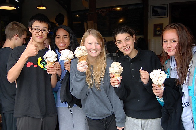
Ice Cream Stop. Left to right – Suzy, Captain John, Skippy the wonder squirrel, your author, Sir Arthur Fuzzybottom III.
At this point, our plan is to head west and ride on roads right next to the water, but the wind has slowed us down considerably and we need to make up a little time, so our host and part-time SAG driver G makes an executive decision to just ride north. This will cut a few miles off the route, but limit how much time we spend in the headwind. There is much rejoicing. Right before we head out, I take a salt tablet and a couple of ibuprofen. We do the slowest paceline rotation I’ve ever been on (I don’t know – 14.5 MPH or so), nobody is having any fun at all, and the miles slowly pass. We finally hit the start of Chuckanut drive, with 92 miles on the clock.
There are some nice roads in the Puget Sound area, but few roads are as picturesque as Chuckanut drive is; it’s really the highlight of the whole trip. It alternately climbs and descends right along the edge of Puget Sound, and you get incredible views of the sound as the road winds through the forest. It’s pretty good in a car, but nothing comes close to riding it on a bicycle. I’ve been feeling much better on the last few miles, so I’m on the front, when the group breaks as G. flats. He sends word forwards to go ahead and not wait for him, so we head towards the start of the climby bit. I’ve picked up the pace a bit; since I’m feeling better, I’m curious what I have in my legs. D and I are riding together, and we hit the first climb, which is about 125’ but not very steep. I ride fairly hard, D drops back a little, but catches up at the top.
I put a little more power in on the next hill. My legs feel fabulous. I go much harder on the next hill, and it’s clear that I have a lot left, so I go very hard up the hills and recover on the descents, and before I know it, I’ve traversed the 10 miles and 7 hills, and am waiting at the park at the exit. I pull off, have a bit of cookie that I picked up at a quick stop in Conway, and the SAG wagon pulls up. I tell them I’m going to wait for D to show up, and they drive off. She shows up a few minutes later, and we ride through Bellingham to the hotel.
After I check in and shower, I head out to meet the group for dinner, and we head out to a nice Italian place. I eat a salad, some bruschetta, spaghettini pomodoro, and part of the chicken parmesean from another rider’s dinner.
Stats
Distance: 107.16 miles
Time: 7:13
Average: 14.8 MPH
Average Heartrate: 116 BPM
Garmin calories: 6345 (not even close to 900 cal/hour. Maybe 500)
Average Cadence: 77 RPM
Elevation Gain: Unsure – my GPS was acting up. My guess is around 2000’.
The pace is pretty darn slow for that long of a ride. Note the low cadence – that means more pressure on the pedals, less pain in the butt…
Here’s the strava for the first day.
Day 2
I sleep well and get up at 6AM, head down to the hotel’s breakfast buffet for small bowl of cereal with very little milk, and a hard-boiled egg. I take a bagel to eat later.
We roll at out 8AM. After 15 minutes, my legs feel pretty good, and the rest of me… well, you can take it for granted that both my neck and my butt will be hurting until the finish, so I’ll stop talking about that. We zig-zag north and east through the farmland – thankfully the wind is much diminished – and we make good time. I split the group a couple of times, and slow down so that we can stay together. At Sumas we cross into Canada, and a few miles later, stop for lunch at a dairy (35 miles). I have a nice ham sandwich, chips, another Coke Zero, and once again, eat my lunch sitting out in the sun. At this point, our group is swelled to 11 as we are joined by another couple riders.
We head out after lunch; I’m trying to ride gentle for the group (my pulse is 105), and I split the group again. I drop back to talk to G’s wife, R (she is current riding and G is driving the SAG car), and she suggests that I just ride ahead. I am joined by D and L, and after some discussion, a target speed of 17 MPH is established. We settle into a nice paceline rotation on the straight sections. Well, that’s not exactly true – we are trying to navigate based on the cue sheet (I have my GPS but navigation mode uses lots of battery, so I don’t use it all the time), which uses road names that do exist in the proper arrangement but has distances that appear to be mostly fictional (I’ve decided that “historical fiction” is the proper classification for the cuesheet). Sometimes the turn we want is half a mile instead of 4 miles, other times it’s the opposite. We’re up to the 18-19 MPH range when we aren’t craning our heads looking for road signs or turning around to find a turn that we missed. I am happy that we are together; I am not sure that I would have found all the turns if I was on my own. We stop at a starbucks near Promontory for a nature break, and I pick up a nice oatmeal cookie and some water. We’re at 52 miles; the cue sheet says that the whole ride is 81 miles, but the mapping I did before suggests that it’s 75 miles. Either way, we have at most a couple of hours left of riding. The day so far has been very flat, and it’s pretty much going to stay that way.
We head back out. We’ve been staircasing to the northeast; head some to the north, then head some to the east. Eventually, we’re going to have to cross the Trans-Canada highway, and we head north on a Chilliwack river road, which winds around quite a bit and takes us to where we are right next to the highway. Then we turn east again; it’s not quite time to cross the highway. We are pretty consistently in the 19s as we just want to get the ride over. We are riding into Rosedale looking for a park with restrooms, when my bike makes a strange ping. It first, I think that it’s just a stone that got picked up, but L tells me to stop, as I’ve broken a spoke on the rear. We have about 11 miles left, so I squeeze it between two spokes where they cross and decide that the wheel is true enough to ride on. I take it easy for a few minutes, but the bike seems fine. We are nearing “the bridge”.
The bridge will take us over the Frasier river. We arrive to find that it has no shoulder at all, and we decide to ride it as fast as possible. I’m at about 20 heading up the slope, 30 down the slope, and 25 on a really long flat spot, until we finally get across to a spot with a shoulder. The cars are generally well-behaved, but they’re going about 35 MPH faster than we are, and did I mention that there is no shoulder?
We go through a few more small towns, wicking it up to 20 on the flats, and after a while longer, we finally arrive at the finish. We ride into the resort, and check in.
The remainder of the day is taken up by the aforementioned massage, beer and apps, a nice dinner with very good company, and a soak in the hot tub. Then a well-deserved sleep.
The next day started with a light room service breakfast, and then a trip back home. The trip home seems really strange; not only do you get places much faster, but 60 MPH on Canada route 1 is very different than 18 MPH on the backroads through farmland.
Overall, it was a very nice ride. The route is nicer than RSVP, the ending point is prettier (though there’s more to do in Vancouver), and the lunch stops are very nice. I only have one reservation about recommending it. It’s that the current route can’t really support more than 50 people (not coincidentally, 50 is the limit on the ride), and it would be unfortunate for it to become a victim of its own success. The slow speed was a choice that I made – I could have ridden on ahead earlier on both days, but I didn’t want that kind of ride.
Stats
Distance: 75.30 miles
Time: 4:41
Average: 16.1 MPH
Average Heartrate: 102 BPM
Garmin calories: 4275
Average Cadence: 72 RPM
Here’s the strava for the second day.