The Devil’s Mountain

After a 6-day guided tour along the coast in California, I found myself at my sisters house in Walnut Creek (east of Oakland) with my bicycle and riding gear, and remembered that she lives near a pretty major climb – Mount Diablo. I borrowed my wife’s laptop (I was deliberately laptop-free on the trip), did some research on some bike forums, mapped out a route in ridewithgps.com, downloaded it to my Garmin, and got ready. The next day, I got up early to avoid the usual heat, and found that it there were scattered clouds and it was in the low 60s. Perfect.

I rode into Walnut Creek, hooked back south, and rode towards the entrance.

The riding was nice, and I soon hit the North entrance:

There are two entrances to the park; a north one, and a south one. I chose the north one because it’s regarded as the harder way up (I’m not likely to have the opportunity to do it again in the near future), and because the road that I rode to get to it is a better choice early in the morning. The climb from this side is 11.1 miles and 3448’ of climbing, a nice HC segment and the second one I’ve done in four days. The weather is still cloudy, which makes the climb cool. There’s an easy 2-3% section at the start, and then the climb settles down in the 6-7% range. I climbed pretty fast a few days ago and I quickly settle at about 220 watts and a heartrate in the low 150s. I pass a guy that is much slower than me, get passed by a guy much slower than me, and wind back and forth up the switchbacks. There is no other traffic; I don’t see a single car for this whole section. It’s peaceful but the pace is fairly hard; mindful of the length of the climb I’m trying to keep up with my Nuun and eating some cheese-its now and then (they are my new cycling wonder food). Eventually, I hit the ranger station where the north and south road meet the summit road; I hop off for a quick break and, clued in by the internets, walk around the back of the building to refill my water bottles. I’m about halfway.

I head out, read and ignore the sign that says, “HEADPHONES IN BOTH EARS ILLEGAL”, and start up. It’s sunny now, but really not very hot. This section is about the same as the earlier section, and I settle back into a groove. It’s more crowded because of the people who come up the south side (which, in addition to being easier, is considered to be easier to get to from BART), and I pass one rider, and then a group of four. A guy slides up next to me, says “cool paint job” (my bike has is a Trek ProjectOne), I speed up a tiny bit to talk to him about it, but after about two minutes tell him that I need to slow down because I can’t hold his pace. He apologizes for making me ride too hard, and rides off.

I continue to climb at a nice pace. Eventually, the road tips up a bit, and the climb is in the 8% range, maybe a bit more. I pass a couple of more cyclists and get passed by one more, and finally start getting near the telecommunications towers on the summit. I round one, and then am at the finishing summit pitch. This is an host 17%, and while it isn’t that long, it’s long enough. I stand up and gut it out for the last little section, ride to the top of the parking lot, and then get off my bike and pause to catch my breath. There are seven or eight other cyclists here, and just one car. The observation tower is closed, so I have to settle for the views from the summit parking lot.

There are some more summit pictures here.

After taking pictures, I look around and see that a couple in a tandem is at the summit. I did not pass them along the way, and they showed up close behind me, which means they were either climbing as fast as me, or perhaps a bit faster. I walk over and tell that I admire their insanity for doing the climb on a tandem. I get back on the bike, and start rolling down.

The road is either 15 or 20 MPH on the way down. I hadn’t noticed it on the way up, but it’s a pretty curvy road; some sections are easy to do at 25, but you are going to be slowing down to the speed limit pretty frequently and you will be on your brakes for quite a while. One car waves me by on the way down (it’s easier to be fast here on a bike than in a car), and I descend down to the ranger station. I turn to the south this time, and descend down that section. I’m following the route on my GPS, when the path suddenly veers off, but the road keeps going straight. I stay on the road, and can tell it’s the right road by the trickle of cyclists heading towards me. I’m soon back in the neighborhoods, and I stop to figure out where I am. The route seems to be clipped off, heading straight back rather than following the route I designed. I think it’s probably a designed-in limitation in RideWithGps. I spent some time looking at the route this morning, and am sure quite that I can’t make all the turns I need to makme, but I also know that if I just head west, I’ll eventually run into bike trail, and I know how to get back from there. I turn in the direction I want to go and head off.

Eventually, I ride into Danville, and under the 680, and I pick up the trail and ride back. There’s a final 15% climb up into the neighborhood, and then a nice 20% driveway, and I’m done.

A very nice ride. I lucked out on the weather, the climb itself was the right level of challenge; the only thing I didn’t really enjoy was having to use my brakes a lot on the descents; I’m spoiled by the long fast descents around Mount Rainier.

My second HC ascent in four days, and my second Strava Extreme rating.  217 watts for 90 minutes. A great way to spend the morning.

Strava link.


Monterey to Santa Barbara Wine Country Biking

A few years ago – when the offspring was younger – the three of us did a couple of family multi-sport bicycling tours through Bicycle Adventures. We enjoyed them thoroughly, and early this summer, the wife and I were talking about the a summer vacation, and decided to do an adult-only bike tour (the offspring works the whole summer and then heads back to school). After checking into a few options, we decided to do the Monterey to Santa Barbara Wine Country Biking tour offered by Backroads.

This was close enough – California – that we could drive down, which would allow us to drive down, bring our own bicycles (we both like our bikes, and I have a PowerTap on mine), and visit my sister in Walnut Creek on both ends of the trip.

The trip is billed as one of their “Premium Inn” trips, and priced accordingly (though none of them are cheap). My well-known cheap (I might choose “frugal”) nature means that I’m not big into the premium hotel experience, but it was one of the best fits for our schedule.

We drove down over a couple of days, stopping in Klamath Falls for a night. I our younger and stupider days, we probably would have driven all the way through (13-ish hours).

In the following, all names except for the wife’s will be initials, to protect the innocent.

Day 1 – Monterey to Carmel

We left Walnut Creek early (as both of us hate being late) to the Hotel Monaco in San Francisco, the starting point of the trip. My sister dropped us off there (thanks Sis), and we put the wheels back on the bikes (two bikes fit in the back of an outback if you take the wheels off) and headed into the hotel. We quickly ran into other people going on the tour, so we talked, and we waited, and then we waited some more. Ten minutes after the scheduled departure time, and the backroads vans finally showed up. Our bikes were quickly loaded on top of the vans; I’m a bit paranoid about our bikes because it’s easy to damage carbon frames, but there were no issues throughout the trip. Backroads uses this neat system where they strap a tray to the bike, and then the tray slides into rails on the vans and trailers. This means they can do all the loading from the ground. Slick.

We head out towards Monterey, and there’s not much to say except that it took a 3+ hours to get there. We get to know our companions (which included two other couples from the Seattle area), and then finally pull into Monterey and pick the remainder of our tour members. After a few wrong turns, we end up at our lunch spot in veteran’s park near the top of a hill. The other van is already there, and we join the rest of the group standing in clumps on the grass. I’m hungry and thirsty ==> cranky, and it isn’t helped by the smell of the roast pig cooking in a pit about 40’ upwind of us. Eventually, our leaders call us over to where they have lunch set up.

While I looked at the food, the group did introductions all around. I think the demographics were pretty typical; people who could think about at least a couple of hours on a bicycle each day and could afford a guided tour. We weren’t the youngest people there, but we were pretty close. Since I’m just before the half-century mark, it’s not that common that I’m at the younger end of groups.

The food, when we finally got to it, was good – there was a nice variety of stuff, and it all tasted great. I’ll save some time here and note that the lunches were fine all the way through, though I would like to see more drink options. I didn’t eat too much at this lunch because I don’t ride that well on a full stomach.

Kim and I have had some discussions about what our philosophy is about riding together on the trip. Kim is in good shape and is quite athletic, but doesn’t do the kind of bike riding that I do, so I’m quite a bit faster than she is. We decided to take it on a day-by-day basis; some days we will ride together, some days we will ride part of the day together, some days we will ride separately. There is in particular one mountain climb that I’m sure she won’t be interested in.

After lunch, we get a safety briefing, and then a briefing about the route. I have the GPX files on my Garmin Edge 705 plus the paper directions, so I think we’ll be fine. I get a few things from the snack table (lots of fruit/sweet stuff, very little carb/salty stuff) – some pretzels, a bit of jerky, put some Nuun tablets in my bottles (Grape in one, Tangerine/Lime in another), roll my bike out to the road.

We mount up, and head out, up the 10%+ grade. This is a bit of a surprise on my legs, and I think it’s more of a surprise for the other cyclists, but we slowly climb out of the park. I wait for Kim at the top (well actually, I ride up and down a couple of times), but after a bit she joins me, we walk our bikes down a connecting path, and end up on the road we’re looking for. I do enjoy the descent part the follows, and after a few miles, we find ourselves out near the water, which gives us a very nice view, so we take a bit of a break and a snack. The pretzels end up being peanut butter-filled, which is not to my taste, so I have a bit of jerky. We’re not riding far enough for nutrition to be an issue.

Along the way, I’ve been sampling the contents of my main water bottle, which contains the tangerine-lime flavor. At the stop, I share it with Kim, who describes it as “a tangerine that has been sitting out long enough to get fuzzy”. My description is “Possum, with subtle Meerkat undertones – the terroir suggests one raised on an east-facing slope slightly North of Yakima”. It’s quite nasty – I switch over to the bottle with Grape in it.

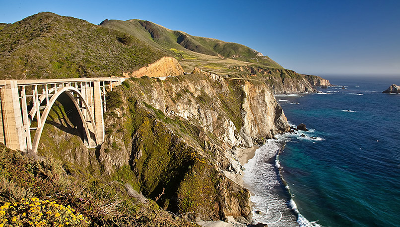
We continue to wind around through the World-Renowned Pebble Beach Golf Course on 17 mile road.

The scenery is great, and we are catching some interesting odors coming off the vegetation – there’s this sharp astringent one which I can’t quite place but is very refreshing, and there’s another one that I decide is best described as “used sweatsock with a haddock in it”. Coincidentally, we did this exact drive on a visit a few years ago, and it’s a lot nicer on a bike.

Eventually, we hit the Carmel exit gate (I toy with calling “Care-a-mel” for a while), and climb up a significantly steep hill, turn, and climb up another steep hill to the hotel, the Tradewinds Carmel. It’s a nice place with a great inside courtyard between the buildings, but apparently they do not attract a particularly intelligent clientele, and therefore need to lead said guests to their room and explain recent innovations such as light switches, closets, natural-gas fireplaces, and the existence of indoor plumbing. I turn off the fireplace, turn off the water feature on the dresser near the door, and we settle in. Dinner is at a nice restaurant nearby and I enjoyed the food and company, and my notes tell me that I was most impressed by the ice cream and sorbet I had for desert. It’s really a bit more food that I would like to eat, but it’s harder to eat well when it’s already paid for (most meals are covered in the price of the trip).

Distance 23.2 miles
Elevation Gained 1703’
Energy 813 kJ
Strava Score 42
Strava Link Ride

Day 2 – Carmel to Big Sur

After a quick breakfast (raison bran/toast/HB egg, which is just about perfect), we head out for the morning briefing. This is a pretty straightforward route down the coast, but I have decided to add in a pointless nasty climb along the way, one with advertised 18% and 20% climbs. There are three of us who decide to do this. I ride with wife through a bunch of turns back onto the highway and then head out, along with E (L1, who had also decided to do the climb, is not in this group). We roll along, and ride past the Point Lobos side trip. After a bit of discussion, we decide to keep riding on. Because it’s a longer day and navigation mode really sucks the battery on my Garmin, I’m not using it (this is a bit of foreshadowing).

After 13 miles, we stop by one of the ride leaders parked with the van, E drops off her coat, and we have a small snack. The ride leader asks us how far we have done, we say “13 miles” (well, I say it, because the cyclometer on E’s bike is only counting about 1/3 of the distance, so she says “4 miles”), and our ride leader says that she thought she went 15 miles. We pull out, and keep riding.

The route sheet says that we will be turning off on “Palo Colorado” at 19 miles. We do some climbing, and at about 17 miles we come to some bridge construction and a one lane road. We wait for traffic to go by, and then follow it up the hill through the construction zone. This is at the crest of a climb, so we descend down, looking for our turn-off, but we don’t see anything. Then we climb a bit, and descend some more. We investigate a possible road at 21 miles, but that’s not it. At 23 miles, it’s pretty clear that we’ve missed the turn. A brief confab ensues; if we continue on, we will be at lunch (which is on our own today) super-early. I’ve told Kim that I will eat lunch with her and E is up for some extra mileage, so we decide to go back, which leads to a 4-mile climb into a very stiff headwind. This is not a lot of fun; I’ve pushed my heart-rate way up, and have just decided to hold it there to the top. We finally get back to the construction, where they are pouring concrete and are totally shut down. We roll to the head of the line, sweet-talk the flagger into letting us go first when they do open it up (“it’s downhill, we won’t hold up traffic”), and 15 minutes later, head back. Descending, I see Kim on the other side, turn briefly ride with her to tell her we’re going back but I’ll still meet her for lunch (yeah, that doesn’t make much sense at this point), and we head back. Finally, after 7 miles of backtracking and about an hour late, we turn off on the Palo Colorado.

It’s a small one-lane road through dense woods, up and down over little hills (hillets?) and back and forth through the trees. All along the side, there are lots of tiny cabins. It’s mostly been relatively easy – about a 5% grade with lots of short steeper parts. After about twenty minutes of this, we get to the first steep pitch, which starts at 11%, kicks up to 15%, and then gets nasty. I’m in my lowest gearing (30/28 IIRC), and I’m tacking all the way across the road. It’s an honest 20% grade, perhaps a tick higher. And it’s in full sunlight, there’s no breeze here, and whenever I get to the right side of the road, a guy hands me another rock to carry to the top. A few minutes later, I finish and rest in the shade; E finishes 30 seconds later, heads over to the fire station to ask for some water, meets a nice fireman, and comes back with water. As we are sitting there, one of our vans heads by; I put out a fist in the “please stop” sign, and the van just goes right by. We don’t need the water and I think we’re mostly okay on food, but since we’re off the original plan it would be nice if our leaders knew what we were doing, but whatever…

At this point, the road descends a little, but unfortunately the daily instructions do not include the profile of the route, so we don’t know how much descent there is in store here. The descent tips up to about 15%, I stop and ask E if she wants to climb back up it on the way back. The consensus is “no”, so we turn around. The 20% slope is a pain to descend, and the road through the woods is dark and torn up, so we have to come down pretty slowly. Eventually, we hit the highway again, and head south.

(Later on, we talk to L1, who found the turn, but ended up turning back before the end because of huge swarms of bugs, so apparently we didn’t miss much).

At this point, I want to fly a bit so that I can meet with Kim for lunch (or, more realistically, not be super late). We get back to the construction zone, where the workers are on their lunch break, so traffic is on automatic with traffic lights. We wait until the traffic goes through, then as the light turns red, a worker waves us through. I climb hard uphill, but I’m only about two-thirds of the way through before there is traffic coming towards me. I move to the side for one car to pass, and then find a bit of shoulder to wait for the rest to pass me by. E has to get off her bike and walk to get up to me, and we journey on. Just a little bit of extra fun. We then get to do the descent with the tailwind again, and we make good time, pass our previous forward point, and continue on.

Things get a bit hazy here – the hard ride back into the wind and the tough climb have taken a bit out of me – but after quite a while, we roll into Big Sur (literally, “Big south”), and stop by the van and some of the other riders at a restaurant. In the morning, Kim and I decided we would meet for lunch at the Bakery, which is a bit farther on (this is a “on your own for lunch” day). Though it wasn’t really made clear in the morning briefing, on the way to the bakery there is a significant hill; 500’ at a steady 7% gradient, and I’m hungry and cranky. We finally pull into the bakery:

I’m ready to apologize to Kim for being so late, but she was visited twice by the flat fairy, and has only been waiting there for about 20 minutes. We order sandwiches, and while sandwich is on fresh bread, it isn’t particularly memorable.

After lunch, Kim, E, and I head back down the hill a bit to a road that takes us to Pfeiffer beach. At the parking lot, we run into guide J with a van, waiting to shuttle a couple of riders up to the hotel. We leave our bike under his watch, on the agreement that he’ll be heading back as soon as the other riders are ready to leave. Since Kim is going to van up as well, I’m not sure why we have to hurry back, but apparently that’s what we have to do, so we head out to the beach – which is very nice, and well worth the trip – but we only stay about 10 minutes so that we can get back.

E and I grab our bikes, and start the climb back out.

With the exception of one 17% section right at the end, the climb to the highway is pretty easy, and we head back up the hill towards the bakery. That part is easier than the first time (the sandwich has helped quite a bit), and we keep climbing until we hit the entrance to the hotel. We’ve been told about the steep climb there, and we climb up that to the restaurant, only to have to descend a bit to cross a small gulley for the final climb up to the Ventana Inn. We pull in, drop our bikes off, and check in. I head off to meet Kim, who is already here.

Given that Big Sur has been a counter-culture mecca (interesting combination of terms there…) since the 60s, I expected it to be a bit different and it did not disappoint. The rooms are in separate cabins and the one we were in (Ridge House) was built out into the canyon, so it’s a bit like being in a rustic but luxurious treehouse. After I cleaned up, the wife and I headed to the Japanese hot baths (the eastern ones, not the clothing-optional ones on the west end (not that there’s anything wrong with that)), and spent a bit of time soaking. Nice. I feel better.

For dinner, we walked over to the restaurant. We aren’t eating as a group tonight, but the dinner is included, so we just show up. We got the four-course menu which normally runs $70/person. The meal was underwhelming; our appetizers were meh, the risotto that I waited nearly an hour to get wasn’t fully cooked and was therefore gritty (this is not rocket science to get right), and the chicken entrée that Kim got paired very bland white meat with a still-raw thigh section. The cobbler for desert was okay.

I had originally planned on recommending the Inn but not the restaurant, but then I happened to see the room price on the website, and I think that even with Big Sur prices, you can do probably do better than $800/night.

Distance 60.6 miles
Elevation Gained 6,546’
Energy 2373 kJ
Strava Score 130 (Tough)
Strava Link Ride

Day 3 – Big Sur to Cambria

This day is a simple straight shot down the coast in three sections. It is billed as:

  1. 31 miles with 3700’
  2. 16 miles with 2300’
  3. 11 miles with 1000’

Kim is going to play this by ear; she’ll ride the first section, and then decide what to do with the later sections when we get to lunch.

The logistics required us to check out of the hotel, walk over to the restaurant with all of our riding stuff, van back to the hotel (to save time), and start riding. This was more convoluted than it needed to be, but we ate our okay breakfast buffet, and headed down to start riding at 8:30.

I rode with E and L2 on this section, and working together, we rode the first section to lunch in just over two hours, getting there at 10:40.

When we arrived, we got told “Lunch isn’t ready yet, you’ll need to wait, it isn’t scheduled to start until noon, but it will take at least 20 minutes until its ready”. I take a quick look at my Garmin, and see that the morning only had about 2200’ of climbing in in, which is about what it felt like.

Since lunch isn’t ready, we walk out to the beach to look at the water, we sit in the sun to warm up, we talk, and by about 11:20 lunch is ready. We eat, I talk to Kim a bit when she rolls in, and she says that she is going to van the next section but hopes to ride the last section. I tell her that I will wait for her there, and we (E, L2, and I) head out to the really tough section. These are real climbs (6% on the first one, 7-8% on the second), but the weather is decent and they only total around 1200’ in total, so it’s really not that bad. I crest the top of the second climb in the lead; E rolls in about 30 seconds later, and L2 about a minute after that. I have cleverly deduced that this is the top of the second climb by the spray-painted mark on the side of the road that says (“all downhill from here”), and, after another quick snack, we roll down to the second stop at Ragged Point.

I trade $2.50 for a small Coke Zero and settle in to snack on dry-roasted peanuts and wait for Kim while E and L2 head off on the last part of the ride.

Kim shows up about 20 minutes later, waits for her bike to come off the van, and then we head out on the last section. I’m expecting that I’ll be doing the ride leader thing and spending my time breaking the wind for this last section. There’s a nice descent and then the road is flat to rolling, and we are making good time. We take a short break to rest on the beach:

And discover that we are making good time because there’s a consistent 15 MPH tailwind. The road is new chipseal and is pretty rough, we stop to let some air out of our tires and it’s much better. Our tires had gotten pumped up by our leaders at some point. Though I’m not sure in retrospect because it’s very hard to judge pressure by how the tires feel, I thought at the time that they were about 120psi.

We barely miss the turn to the hotel, turn around, ride a bit next to the water, and pull into the hotel.

We chill out on their decklet while we wait for the bags to make it to our rooms, then Kim and I take a walk on the boardwalk before dinner. Dinner is in town and very good; I have an excellent heirloom tomato salad with arugula and peaches, a very nice duck breast, and chocolate for desert. I plan to eat only half the chocolate and fail at this completely.

Distance 68.8 miles
Elevation Gained 4,603’
Energy 2008 kJ
Strava Score 102 (Tough)
Strava Link Ride

Day 4 – Los Alamos -> Los Olivios

Today will be a transition day; after breakfast we will get in the vans to skip some boring country, and head into the interior wine country, starting out in Los Alamos. No, not that one, this one. We get there, get everybody unloaded, and head out.

Today it’s about 20 miles to lunch, and then another 15 to the hotel – or, if you want more distance, you can ride more in the afternoon. We are about 5 miles into the ride when we come across a guy standing outside his truck, and he tells us that there is a rocket launching in a few minutes out of Vandenberg AFB, a Delta 4 Heavy carrying a classified payload (this means “spy satellite”). They launch out of Vandenberg because they need a polar orbit, and that puts the launch track over the ocean. This is currently the biggest operational US booster, though the upcoming SpaceX Falcon Heavy will launch about double the payload.

He’s a bit off on the launch time, and most of the group heads out to ride, but we figure out the right time through the wonder of smart phones, and a few minutes later we get to see the launch, and, a few minutes after that, we can hear the low rumble of the engines. At 15 miles away, it’s not as intense as the shuttle launch I took the offspring to a few years back, but it’s still great to see, and it’s Kim’s first launch experience.

With the unplanned festivities out of the way, we head off to climb the first hill, which is a bit of a bear. Both Kim and I are having trouble with the heat, but eventually, we reach the top, get some more water from our van, and continue. We’re only able to ride for short stretches of time before I get too hot, so we ride for a few minutes, rest in the shade, and continue this pattern as we slowly climb to our lunch stop. I am really not having fun in the heat, and at lunch it’s pretty clear that I’m not going to do more than the 15 remaining miles to get to the hotel.

After a nice lunch, a bit of liquid, and modicum of procrastinating, we head out, start climbing again, and soon hit a steep 200’ hill, followed by a descent, and another 200’ hill. I’ve been riding on ahead on the hills and while waiting for Kim and the top of the second one, I feel something hit my hand, brush it away, and end up with a bee sting on my left index finger. I gingerly remove the stinger, making sure not to squeeze the venom sack, and the pain fades after a few minutes; apparently there’s enough of a callous on that finger that it didn’t get very deep.

We finish the ride in, drop our bikes off, check in to the hotel, and then luxuriate in the coolness of our room. Dinner is on our own, which is great as we have more control in our restaurant choice – we share salad, pizza, and a nice burger. Oh, and a nice local IPA for Kim, and a very good Hefe from Germany for me.

Distance 36 miles
Elevation Gained 2,321’
Energy 1027 kJ
Strava Score 102 (Tough)
Strava Link Ride

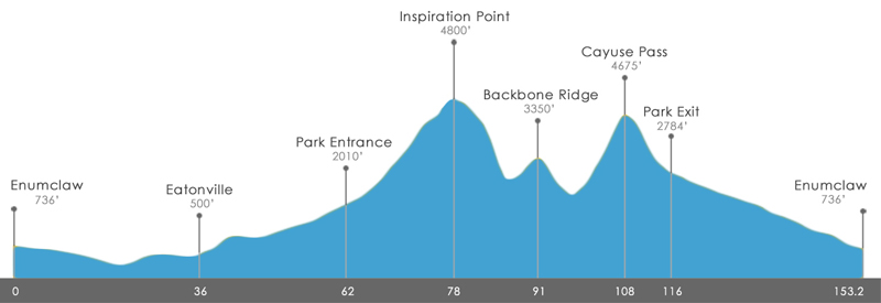
Day 5 – Mount Figueroa loop

Today is a day I’ve been looking forward to for a while.

The plan for today is simple; we – and by “we”, I mean the nutcases in the group – E, L1, and I – are going to climb Figureroa mountain, a 4534’ summit, while others in the group take a more leisurely trip through the countryside, stopping to sit in the shade and taste a nice Syrah.

We head out a few ticks after 8AM so that we can get as much riding as possible before the heat gets bad, and after 8 miles of warmup, we turn onto Happy Canyon Road. After a 7 mile intro which is pretty in a “horse ranch” sort of way (and not pretty in the “lots of cattle guards” way), we hit the meat of the first climb, which will take us 1200’ up over the next 3 miles. The grade kicks up to 6%, then kicks up to 8-9%. I ride with L1 and chat, and while it’s not what I would describe as cool, it’s not hot yet and it’s mostly in the shade, so it’s okay, and the pavement is just a few years old and in great shape. We hit the crest (or, perhaps I should say, the first crest…) and begin working ourselves up the sunny side of the ridge.

Then, not unexpectedly, something happens to the pavement.

We refill our water bottles from our handy support van (I’ve gone through about a bottle and a half so far), and tackle the unpaved section. It’s pretty rocky in places, so we work back and forth, picking our way for the line that is the least rocky and we make steady progress, finally coming to a steep section without a great line. I stand up very gingerly, try my best not to pedal smoothly, but still spin the rear up a couple of times. No harm and no flats, however, which makes us all happy, and we hit the top. We descend about 300’ into the next canyon.

We start to climb gently through some woods, pass over a couple of very minor steam crossings, pick up some really annoying bugs, and then the climb begins in earnest. The grades are in the 12-13% range, we’re in the full sun, and there is no breeze here. I try to hang with L1 for a few minutes, but my heart is making a thumpity-thump sound that tells me I should back off a bit. I tack back and forth gently to reduce the grade a bit, and continue to progress at about 6MPH in my lowest gear. In two miles, we climb about 900’, which doesn’t sound that bad – only about 9% average – but it includes my tacking back and forth, so it’s more like 11%+. I finally hit the saddle (Cachuma Saddle, as the next picture tells me) where L1 is waiting, and E rolls in a minute or so afterwards.

We take a few minutes to rest and hydrate, and then it’s time to tackle the final pitch.

I’m in reasonably good spirits; I know there’s a lot of climbing left, but we’re out of the “Happy Canyon” now and there’s a hint of a breeze. We head out; L1 in the lead, me in the middle, and E in the back. L2 soon pulls away; I’m having trouble with the heat and just can’t climb any faster. After a few minutes, I come to this sign:

Later I learn that California is strange in that there is very little public land; when it came from Mexico, virtually all the land was divided into private land grants, so this area that we’re riding through is, in fact, private land. Though I’m not sure who is going to be trespassing down into this steep canyon.

As I put my camera away, E rides around the corner, and I decide that it makes more sense to slow down a hair and ride with her than try to keep my pace. We are not climbing back and forth under a peak, we are working our way along a very broad ridge, which means we keep finishing one section only to turn the corner and discover there is yet another section. This happens at least 10 times along the climb, so we just climb and climb and climb some more. The surface isn’t great, but it’s fine for the speed we are travelling, and there is no other traffic out here. The gradient ranges from 8 to perhaps 13%, though at this point, I’m not paying much attention to my gps, and I can’t read it very well anyway because some of my sweat dripped on it and there’s a crystalline river of salt running diagonally across it.

We have been told there’s a steep section near the top, and as I near a gate that I hope is the start of that section, I stop so that we can “take a picture”, but it’s really to rest up before that last push.

And it turns out the last section is only about 12% and not very far at all, not really much of a final challenge. The section is punctuated by our support van driver catching up and passing us, with “Eye of the Tiger” blaring from the speakers. We turn the corner and stop at the top. It’s was a hard climb, but I feel pretty good at it; the heat did slow me down a bit but I was pushing 200+ watts pretty much the whole way, which is about 20% more than I pushed up Cayuse on RAMROD, and it is hotter here.


Left to right: E, Professor Snuggles, L1

We reload our water bottles; I get my hair wet and pour some water on my jersey, and we start the descent. The road ducks into the trees, and we’re treated to a road that looks like this:

We ride this very gingerly, but it doesn’t last for very long, and we are soon back to pavement that is mostly clean. Unfortunately, it’s pretty badly patched up in places, as steep as the side we came up, and just as curvy, so we aren’t able to go down it very fast; I hit 30 MPH at one spot, but most of it is at 20MPH, and there are a bunch of curves that require < 15MPH. Oh, and the random cattle guard, which is way more fun at 15MPH that 6 MPH. We spend a lot of time on our brakes, and have to stop twice to let our hand muscles uncramp. Not really the kind of descent you’d choose to have, but eventually we cruise down to the flat part of Figueroa Mountain Road, and we pull up to the van for one last water break. On the other side of the road, we see this:

This is the entrance to Neverland Ranch. People drive (or ride, I suspect) out here to have their pictures taken, but it’s just a gate.

We head out, and ride the rest of the route back into Los Olivios, and then out to our lunch spot at a vineyard. While I’m there, I take a quick picture of my helmet. Yes, I am a salty sweater.

Distance 45 miles
Elevation Gained 5000’
Energy 1910 kJ
Strava Score 158 (Extreme)
Strava Link Ride

My first extreme rating on Strava, and on an HC climb. Yea!

Day 6 – Short loop through Solvang

Today we just have time for a quick morning ride before we check out and head to Santa Barbara and other places. This features a short climb at the start, and then a nice 1-2% downhill for quite a while through farms and vineyards. That part was very nice, then we climbed a short hill into Solvang which adopted Dutch architecture after WWII, and now has a decidedly quasi-Dutch feeling. Interestingly, in the late 1950s, a couple visited Solvang and decided that adopting an approach would work well for their town, which Washingtonians know as Leavenworth. My impression is that Leavenworth does it a bit better.

On the way back, I stop to take a picture of an important sign:

If you’ve ever ridden on an organized ride and followed markers painted on the road, you can thank Dan Henry for that.

A quick spin back to the hotel, shower, and we’re back in the vans heading to Santa Barbara airport, where Kim and I will get a rental car and head back to my sister’s house in Walnut Creek.

Distance 16.2 miles
Elevation Gained 815’
Energy 453 kJ
Strava Score 18
Strava Link Ride

Summary and comments

It was a pretty good trip; the time we spent along the coast was really nice, in climate, in challenge, and in sights. I was less excited about the wine country section; I’m not a big wine drinker/taster at any time, and really not into stopping at wineries while on a ride, but I did get to spend a really good day on a serious mountain climb, which was nice, plus a rocket launch. A bit too hot for me, however.

Distance 249.8 miles
Elevation Gained 20988’

Back in Walnut Creek, I managed to throw in another HC climb of Mt. Diablo (39.2 miles, 4164’) on Sunday to cap off the trip.

If you want to read my review about the trip, you can find it here.

·


Review: Backroads Monterey to Santa Barbara Wine Country Biking

Recently, my wife and I went on this guided tour. You can find my tour writeup here.

The tour was 6 days long; a half-day at the start, four full days in the middle, and a half-day at the end. It’s really two separate rides; the first half is along the coast, and the second half is inland in wine country.

High points

I loved all the riding along the coast, with the possible exception of a small sidetrip that wasn’t great but which we were amply warned about. The views were breathtaking, and travelling it on a bicycle is much more immersive than doing it in a car. And we had a tailwind for most of the section. The riding options were a reasonable compromise for the more and less experienced cyclists; I was able to find most of the challenge I wanted, and my wife was able to have a good time as well. We could ride some sections together and some sections apart.

The riding in the wine country was a little less exciting overall (well, I just like the coast scenery better) and was much hotter, but it did feature a hard mountain climb option, and that was a good choice.

All of the places that we stayed were fine. They were a little higher-end than my typical preference (due to my well-known frugality), but it is billed as a “Premium Inn” tour, and it does live up to that. The food was good to excellent, with some great usages of local ingredients, with the exception of one dinner at the Ventana Restaurant, which managed to disappoint in both food and service.

Low points

We had heard in the past that there was a bit of attitude associated with the Backroads folks, and I’m sorry to say that it was true. After being introduced into the ride food table and being told to ask if there was anything we wanted that wasn’t there, I asked for some cheese-its, only to be told that “we don’t usually get that because most people don’t think they’re healthy”. On one morning, we left as scheduled at 8:30PM, and when we rode the 31 miles to lunch in just over 2 hours, we were told that “lunch is scheduled to be ready until noon”. Most of the interactions were fine, but these are a bit annoying, because there were much better ways to handle the situations. There was also this weird thing where we had two ride leaders and one part-time ride leader; the implication was that the part-time one wasn’t there to help us but was there to help out the main ride leaders. I don’t really understand the arrangement, nor do I understand telling the guests about it in the way they did.

The first day was a bit uneven. The Backroads folks showed up late to the hotel that we were departing from, and when we got to our lunch destination, they sent us out to stand in the sun on a grassy spot while they set up lunch, pulled all the bikes down, and set up the ride snack table. Then we had to do introductions before we could eat. It would have been nice to have something to drink while we were waiting, and they could have put the introductions after lunch. Then, the ride starts with a steep climb up out of the park where we had lunch. Not really a very kind introduction for people who don’t really ride that much.

Things got better after that, but there were still a few hiccups along the way. I missed a turn with another rider on the second day, which was mostly our fault, but I think they could have anticipated the mistake that we made and given us a bit more help not making it. There was a big climb at the end of that day that really didn’t get talked about during the ride briefing.

As a serious cyclist, there were a few additional things that bothered me. My tires got pumped up (great), but I think the inflation wasn’t where I wanted it. It would have been simple to ask me what I preferred. The elevation gains on the third day were way off, the three options were listed as 3700’ / 6000’ / 7000’, but the actual elevations were 2256’ / 4008’ / 4603’. That’s a pretty significant difference; I ride a 4500’ day very differently than a 7000’ day, and there are lots of easy ways to do that right, so it was a bit annoying. All the other days seemed pretty close.  I was disappointed that the daily route directions didn’t have elevation profiles on them; it seems like a really obvious thing to do and something that would be useful to all of their guests.

One final low point – Backroads has started offering electric-assist bicycles on their tours. We had one person on our trip riding one of these bikes, and found a few issues:

  1. It makes it too easy for somebody with little or no cycling experience to hop into a tour. The route along the coast was pretty busy at times, and somebody can easily get in over their head.
  2. Cyclists on the electric-assist bicycle are faster up hills, but tend to be slower on descents. That means the electric-assist bike passes me on the hill, then I have to look for a place to safely pass them, which is hard to do because they are not predictable descenders. I finally pass, and we repeat it on the next hill.
  3. They have the speed to ride with a faster group but don’t have the skills or the experience to do it well. I’m leading a paceline with two other riders, and an e-assist rider as the fourth person. I pull off the front, and drift back. I’d like to grab the 3-spot, but I can’t, because the e-assist rider is there, and they don’t know the etiquette. I therefore have to drift back to the back, but I can’t draft because I don’t trust the skills of the e-assist rider (they move around and slow down randomly). I have to hang back from the e-assist rider and just wait. Cyclists tend to self-organize on speed, with faster riders tending to be those with group-riding experience, so those at the front are generally fine on their own. Throw in e-assist bikes, and this breaks down, and makes my experience decidedly worse.
  4. They cheapen the experience. Everybody came here with a bit of challenge in mind; maybe it was riding fast for a whole day over a hilly route, maybe it was just riding 30 miles over a hilly course.

It was annoying with one e-assist bike. If there were multiple ones, it could be much worse. I can understand the marketing potential, but I don’t want to be on a tour that has them.

Summary

Despite all the things I found to complain about, we both really enjoyed the trip, but we enjoyed the ones that we did with Bicycle Adventures in the past more.


RAMROD 2013 Ride Report

This year marks the fourth time that I have gotten up far too early, journeyed to Enumclaw, and hauled my body around the mountain (to be fair, in 2007, road closures meant that I hauled my body back and forth along the east side of the mountain). Perhaps it is true that as one gets older, one loses the capability to learn.

The event has not been particularly kind to me. A lesser man might blame the tides of fate, the sands of time, the grapes of wrath, or the whims of mother nature. I do not. The problem is my simple lack of willingness to train properly for the event. I’m only willing to devote about 8 hours/week to training during the season, and that hasn’t really been enough to thrive on the ride. I also have had some bad luck. If you want the the details, you can find them here, here, and here

This year, I decided to try something different. I bought a copy of Carmichael’s, “The Time-Crunched Cyclist”, went out and did a field test (always a fun way to spend 20 minutes), and started making up a training schedule. This was a bit challenging, since I lead a ride for Cascade Bicycle Club two evenings a week, and I have to figure out how to fit the workouts into the rides. This hasn’t always worked, but I can say that the loads of time I’ve spent on the intervals has made it much more comfortable to ride at my aerobic threshold than before; my legs are hurting but I’m not out of breath. When I get a bit of rest, I’ll redo my field test and write a more in-depth report.

This is also my first year “training with power”, since I picked up a Powertap hub last December. I expect to lean on it heavily to ride at a reasonable speed on the climbs.

I’ve also cut out some snacking at work and at home. Back in April, I saw 181.6 on the scale, and the morning before the ride, the scale ticked back from 170.0 to 169.8. Bike + Eric is now about 6% lighter.

My big goal on the ride is to get my nutrition better. I’ve been okay on hydration – working through a bottle of my Accelerade-based drink and a bottle of Nuun over two hours or so – but I have not been eating enough. So, I’ll be trying to eat more.

As for the ride, I plan on riding easy for the first 60 miles, riding a bit harder but conservatively up the Paradise climb, and then – assuming I’m feeling good – pushing the pace up Cayuse.

Prequel: The crisis

After leading an Eastside Tours group ride two weeks before the ride, I come home with a slight cough, which worsens over the weekend. It’s not horrible during the day, but I’m spending the nights on the couch in the basement trying stop coughing, generally for 3 hours or so.

The next week I’m in training at work, so I can’t get to the doctor, so to make sure I don’t get sicker, I find somebody else to lead on the evening rides that week. Not really… what I actually do is lead the rides, cough deeply whenever we stop, and ask the other riders to help out because I can’t talk in a loud enough voice to give directions. I finally get to the doctor on Friday – he interviews me, tells me that he’s seen some “really strange symptoms” recently, and hooks me up with a five-day course of Azythromycin and a bottle of old-school cough syrup (you know what I’m talkin’ ‘bout). This wasn’t the kind of taper I was planning to do, but I’m stuck with it, and the antibiotics do help after a couple of days. I’m not coughing my lungs up any more, but I’m a bit tired and I have a weird tightness in my right IT band near the hip, presumably from the nights “sleeping” on the couch…

Episode I: Preparation and Exploration

I get up at 3AM, eat a small bowl of cereal, get dressed, and hit the road. I arrive in Enumclaw about 10 minutes before the start, pull the bike out of the car, and do a weather check. Despite wearing my rails to trails jersey – which has lots of pocket space – I have a lot of stuff to put in it, and anything I wear in the morning I have to carry the rest of the day. My hope was to just get by with arm warmers, but 90 seconds of exposure tells me it’s a very cold 58 degrees, so the vest goes on as well. I head over to the starting line, take a quick nature break, and roll to the start line. The volunteers pull my starting tag (the track riders around the course), and I head off into the predawn, turning on my flashing LED front light. The time is 5:08.

According to reputable sources, the word “Enumclaw” translates to “place of evil spirits” in the language of the Salish Native Americans. In the gradually lightening skies, that does not seem too far-fetched.

I roll out into the darkness, a bit apprehensive of what is to come. A week of gentle tapering and illness have left me with quads that hurt, an unsettled stomach, and a sort IT band. After a few minutes, I turn left into Buckley, almost miss the same right turn I almost missed last time, and am quickly passed by a group of four. I generally like to warm up a bit before I latch onto a group, but I have a new source of information – my power meter. I hook on and find out that I can easily hang with the group at 110 watts, which is pretty easy, so I stay with them. I am expecting to roll through the group to take a turn on the front, but the guy in front isn’t budging, so I settle in at the back. We ride for about 30 minutes, hit the low point of the ride, and head left on Orville road.

At this point, the workers in the group pull off for a “nature break”. Being the first person left – and therefore the defactor leader of the remaining group – I keep riding but at a reduced pace since we’re no longer descending. I reach into my bento box and pull out a Honey Stinger Chocolate Waffle.

I bought these because they have a picture of Lance on them, and I’m hoping that they contain some of the “special ingredients” that Lance used to get from Dr. Ferrari. After a little bit, we hit some slight hills and the group breaks apart. I end following a guy with aero bars and a very creaky drivetrain. This is one of my favorite parts of the ride; on the left we can see the waters of lake Kapowsin with an early morning mist rising off of them. A group of 3 riders slowly passes us, and I notice that the last rider in the group has a very special number attached to his jersey.

RAMROD has this interesting tradition – it assigns jersey numbers by the age of the rider, with the oldest riders getting the lowest numbers. The rider who has passed me is wearing the single-digit number “1” on his jersey, and – if I recall the history of RAMROD correctly – is in the early stages of his 30th ride. After a while, he tires of the pace, and goes to the front of our group to pull for 5 minutes. He pulls off, and I’m now second-wheel to a woman in a team kit. She pulls for a couple of minutes, I prepare for my turn at the front, and in a bit of exquisite timing on my part, we hit highway 161 and turn left. This is the first real hill of the course, a short 280’ climb up into Eatonville. I make my usual “nobody told me there would be hills on this ride” joke, and she laughs. We roll into the first food stop.

I park the bike, take a nature break, eat a small blueberry scone, and then refill my bottles. I’ve pretty much hit my nutrition plan; I went through both bottles and had a waffle and some triscuits. As I’m heading out, I run into my friend Alan who has just gotten in; he left 20 minutes after I did but was riding with a group that was much faster. This will be a recurring – and expected – theme for me today. I spent 12 minutes at the stop.

The next section is 25 miles and we will climb up about 1300’ during the section. It starts with a few hills, a slight descent, and then a slow climb in the 2-3% range. I end up pulling a group at perhaps 175 watts; this is a little more than I wanted to be doing, but I keep doing it. I do eat some more, but I don’t drink as much as I should. My stomach is still feeling unsettled, and every once in a while rises above that to reach the “nauseous” level. My legs also still feel weird. This is a really pretty part of the ride, and I spend quite a bit of time looking at the scenery and chatting with the rider behind me. Pretty soon, we reach the Wildwood food stop, at 58 miles in.

It’s old home week at the rest stop; I talk with Alan, Francis, Mark, Lizza, Daniel, Laurie, and a few others who I can’t place (being a ride leader means that that I have a lot of asymmetrical acquaintances, where somebody knows me (and knows my name) better than I know them. It’s a little weird and embarrassing at first, but I’ve run into this in the past in some work-related settings). Two people thank me for my RAMROD 101 post. I do not feel as good as I had hoped, in fact, I don’t feel very good at all, but there is nothing to do but keep riding. Time off the bike = 12 minutes.

Episode II – The Test

I head out from the stop, and very soon, the route enters the national park. At the entrance, they have a lane for us (we have already paid for park entrance as part of our fee). There are volunteers out to record rider numbers, so they know where to look for riders if they don’t show up (this is a significant concern; with fast-ish alpine descents and not-so-great road conditions, there are incidents, and last year a rider went off the road on one of them and ended up dying, so it’s important that they know where to look for missing riders). I don’t put a number on my bike because it gets in the way and flaps around on the faster sections, I don’t put it on my helmet because it looks stupid, but I do have my number on my back. One of the volunteers repeatedly yells “what is your number! I need your number!”. Well, first of all, all that I know right now is that my number is in the 400s, second of all, they shouldn’t listen to what I say because I might have it wrong, and thirdly, I can’t talk loudly because my throat is bothering me.  If I was in a group I would have stopped to make sure, but since I’m all alone I figure that can read it from my back and I just roll through. I then roll through the RFID reader that they’re trying out this year, and I’m on the way up. The entrance to the park is at 1800’, and we’re going to top out at a little over 4800’, so we’re talking a 3000’ climb in the next 19.5 miles.

The first section of the road is about 10 miles, and has us winding through the woods and up to Longmire on a 2-3% grade. The forest canopy totally covers us, and there isn’t much traffic, so it is very peaceful. I settle for climbing at about 175 watts at a cadence of about 90; I’m a stronger climber at 80 RPM but I’m a bit concerned that I can’t push that for the rest of the day. My heart rate is about 130, which is in the meat of my range, but this feels harder than I had hoped; I think the time off and the sickness are coming back to get me. We pass through Longmire, and the grade stiffens a bit, into the 4-5% range. I stop for a minute to stretch and rearrange my food for better access. I’m probably not drinking as much as I should here. I’ve passed a few people so far, and been passed by a lot more – this is also expected. At one point, as I pass a triathlete I’ve been slowly catching for a while (the bottle holders on the back of the seat are a giveaway), I say hello, and he says, “How are you doing today?” That’s a little chatty for this sort of climb, so I take a closer look, and it’s Paul, a friend of mine. Paul is a serious triathlete – Ironmans (Ironmen?), marathons, that sort of thing – which either means I’m climbing pretty well, or he’s slow. It turns out that it’s a little of both; he hasn’t been doing as much riding as usual. I drop my pace to ride with him, and we chat as we keep climbing, which is hugely useful to me – this climb keeps going and going, and I’m keep thinking we’re near the top, only to get disappointed. We pull into a water stop, which surprises me, as the traditional water stop is at the top of the climb. I spend 7 minutes there; just long enough to refill my bottles and talk to Laurie and a few other cyclists a bit. There are two ways out of the parking lot; you can go back to where you came in and continue the climb, or you can head straight. Straight seems shorter – and it is – but what I fail to notice is that the parking lot is flat, so I have a nice 10% climb to get back to the road. Thankfully, it only takes 5 minutes to dispatch the rest of the climb, and then we are greeted by a nice section of gravel road – the reason for the water stop being lower on the climb – which is a bit of joy. It’s okay except for the one point where I hit a section of deep gravel and the bike has a different idea about direction than I do, but I roll through.

Climb stats (from Strava)

Distance: 19.4 miles
Elevation Gain: 3012’
Time: 2:02:07
Average speed: 9.5 MPH
Power: 167 watts
HR: 133 BPM

I know I wasn’t doing great on the climb and not feeling well, so I’m okay with that. It’s a PR for me only because my previous trip up was an angst-ridden slice of not-fun.

I take a picture (which comes out pretty nice for a phone), and head out to the Stevens Canyon descent. This is generally a fun descent; the grade is a fairly steady 5%, and it will take me from 4800’ down to about 3000’ in about 13 minutes; a bit faster than the way up. I would normally lightly pedal this out to keep my legs warm, but for some reason the upper right part of my right calf (near the IT band) is hurting quite a bit, and I decide to rest and coast. That doesn’t work very well either – it hurts just as much. So, I HTFU, and try to bear it on the way down. That takes me to the Upper box Canyon food stop. I grab a cookie, have some potatoes with seasoned salt (but perhaps too much salt…), and refill my bottles. I know that NSAIDS and exercise don’t really go well together, but the pain in my leg has me concerned, so I take a couple of ibuprofen and head out riding with Laurie. Elapsed stop time, 13 minutes.

Episode III – Dehydration and Disillusion

We descend another 200’, and then start the backbone ridge climb. The 2.3 mile, 563’ climb is dispatched in a hair over 19 minutes at 171 watts. I reach the top quicker than I expect, and run into one of my riding group logging rider numbers. As I head over towards the descent, one of the volunteers tells me that this crappy, torn-up, borderline-unsafe road is newly paved. The 1100’ descent is glorious; the pavement is perfect, and the 20 MPH curves that used to be torn up and bumpy are smooth and easy. The only thing that would make it better is if I felt better, but even so, it is over too soon.

Which brings us, finally, to Cayuse Pass. I ride the first 3 miles – a bit of a preamble – and then I’m in the meat of the climb. 8.8 miles, 2500’ of climbing, but at a 6% grade, steeper than Paradise was. Status check: I’m hot, I’m dehydrated, and I don’t feel very good. Mood=cranky, which is normal for Cayuse, but makes 90 minutes of climbing seem daunting.

So, I take the climb a little bit at a time. I’m riding at 6MPH at around 170 watts, which means it takes 10 minutes to climb a mile. I ride a mile, stop to drink and rearrange my food and have a little snack, ride a mile, spot an empty patch of shade desperately in need of an occupant, etc. As I climb, I’m listening for a very specific sound – the sound of falling water. When I hear it and feel a cool breeze, I pull off to the side, set my bike carefully into the ditch, take off my helmet, and carefully go on a short hike over to the waterfall (If you haven’t tried to hike over loose rock wearing cycling shoes with cleats on the bottom, give it a try). To reach the water requires me to basically stand in the stream, so I get wet feet, and then I reach down, grab handfuls of water, and throw them onto my head, my front, my back. The water tastes salty because I am pretty salt-encrusted at this point, but it makes me so feel so much better. Back on the bike, and back to the same scheme – climb a mile, take a break, climb a mile. The cooling effect from the waterfall water lasts about 20 minutes, then I start getting hot again. I am not the only one taking these short breaks, where we get to admire the scenery, and the others slogging their way up. We are little islands of suffering, each emptying a personal basket of pain, coming together and drifting apart.

Several days later, I reach the water stop, where I toss my accelerade and refill one bottle with water so I can pour it on myself in the future. I sit down and stretch for a minute. I run into ex-Eastside Tours ride leader Dan, and we chat for a bit. On the way out, I say, “only 3 miles, right?”, and he replies, “4 miles”…

Drat.

Back on the bike, but the grade drops down to 5%, and the combination of that with pouring water on me allows me to ride a whole 23 minutes without a break. Then 15 minutes, then one final push, and I finally come to the highway 410 junction sign, and I roll into the water stop. A very quick stop, and I roll out down towards the deli stop.

I’m hot, tired, cranky, and as soon as I start heading down, my leg hurts again. But, 12 minutes at 30 MPH and 8 minutes at 20 MPH takes me to the deli stop.

The deli stop features custom sandwiches, and is one of the nice things that make RAMROD different. But… and there is a big but… the deli stop sometimes works well, and sometimes doesn’t. In this case there is a long line in the sun, and it’s moving slowly. I grab my nuun and try to rehydrate as I wait for my turn. The problem is easily apparent; you have to wait for the person to get your bread, then you have to wait for the next person to put mustard on it, then you wait for your meat, then for your cheese, and finally for your tomato and lettuce. This is the kind of thing that drives me crazy; a little optimization would easily double the throughput and get rid of the line. Then there’s a volunteer in charge of chips doing nothing because she already has 50 servings ready. I open the coolers to grab a drink, find one is full of juice, and the other has 8 cans of Coke. I can’t drink the coke because fructose doesn’t sit well with me, so I look around, spy a bunchy of diet coke in the refer truck, and tell a nearby volunteer that the there is no diet coke in the coolers. She pulls out one can, hands it to me, and goes back to what she was doing.

Drives. Me. Crazy.

Finally provisioned with food, I score a chair near the amateur radio setup (no cell phones for most of this core so local amateur radio “hams” do communication for the ride), eat my sandwich, chips, drink my pop, and try to recuperate. The deli stop is always a place of bittersweet feelings; no matter how you feel about your performance so far, you have survived it, and the hardest work of the day is done. On the other hand, you have 36 miles to go, and it’s hot, and there’s always a headwind.

Episode IV – A New Hope

After 60 minutes off the bike, I pull the bike off the rack, roll back out onto 410 and head towards the finish. This is a nice section; it’s pretty consistently downhill for about 17 miles, and – unlike the big hills of earlier – this section is more about power/drag ratio and less about power/weight ratio, which is a better fit for me. I’m cruising along, making okay time, hoping that a nice group will pass me and I can hop on. For the first 9 miles or so, I have no luck; I pass 6 or 7 tired souls, but none of them look able to ride the pace I’m currently at, and nobody passes me. I start to get depressed; the flats in the last 20 miles are going to uncomfortable if I am alone.

Then, I hear a bell next to me, and a group passes me. They are going a bit faster than I would like, but, as the old say goes, “coming down the 410, wheel-suckers can’t be choosers”, so I jump and get on the back of the group. Normally, just jumping on without asking would be a breach of etiquette, but it’s pretty much expected on this section of the ride. There are three of them; two of them wearing Speedy Reedy team kit, and another one (friend?) in blue. We’re heading down at 24-26 MPH, which wouldn’t be very impressive on a downhill, but the headwind today is pretty intense. The guy in blue is in front; he peels off, as he drifts back, I tell him “one more on the back”, and he slots in behind me. I tag the guy in the front “Puller”, because he’s working hard and doing a nice job; very predictable pace, and it’s easy to sit behind him. He pulls for perhaps 7 minutes – a long time in this wind – and pulls off. His teammate immediately jumps the pace up 2 MPH (rookie mistake), and I pull up close behind him to prepare for my turn at the front. Four minutes pass, and he’s starting to tire out and slow down, but he stays out there. Another minute goes by, Puller pulls out, rides forward next to teammate, pats him on the back, and they exchange a few words. Puller drifts back, ding’s his bell, and his teammate (who is now tagged “Trainee”) pulls off, and I’m on the front.

The wind is honking bad; I take a quick look at my power meter, and see that I’m at about 250 watts, which is okay for the two-minute pull I have in mind. I concentrate on being smooth and predictable. Riding smoothly has been a goal for me for quite some time, and two years of being in front of groups rides on the flats have improved my skills, so – if I do say so myself – I’m pretty good at this. Looking at your GPS to figure out how much time has passed is a bad idea at the front of a fast paceline, so I count revolutions of my pedals. When I get to 180, I check my mirrors, look over my shoulders, and pull off the the left. As I drift back, I get a “good job” from Puller, and I settle into the back, rehydrate, and wait for my next pull. “Blue” spends about two minutes before he drifts back, which makes me happy – he’s about at my level – and we continue the rotation. On the first half, because of the descent and the headwind, I’m only using 100 watts to stay in the pack, but 250 out front, which is a huge difference (and the reason I really wanted a group for this section). After what seems like a very short time – time travels quickly for me in a paceline), we’re in Greenwater, where the grade flattens out, and in this section, there are even a few uphills. I am grateful that the pace slows to something reasonable – more like 17-20MPH – because the paceline advantages go down as it flattens, and I’m getting a bit tired from my pulls. My toes are also really starting to hurt; wet feet do not improve the foot/shoe interface.

We eventually get to mud mountain dam, and head over towards the descent. Puller and Trainee talk about racing on this, which has me a bit apprehensive; the descent here has a couple of tricky corners, and I don’t think I’m up to “race speed”. Puller is in the front; we descend quickly but conservatively in the tight places, and pull out onto the flats. If this were a just world, the ride would end right here, but we still have 4.5 miles to the finish. Puller pulls for a bit and hops to the back, Trainee pulls for a few minutes and then blows right by a left turn. It wasn’t particularly well marked, but from second wheel I saw a group of riders make the turn 45 seconds earlier, so I figure he’s just living up to his tag. I can’t safely turn in time, but Puller and Blue make it, and keep riding up the road at a reduced pace. I follow Trainee in a U-turn, and we head back, but he’s clearly tired and the headwind is still there, so I pull him back to Puller and Blue. We cross the highway, turn into the school, stop at the finish line to have our tags pulled, and Puller introduces himself (I *think* his name was Jay), and we thank each other for the help in the group (I got more benefit going from solo to a group of four, but going from three to four also has a decent benefit).

I roll to my car, throw the bike in the back, take off my still-wet-from-the-waterfall shoes and socks, and drive around to the parking lot, so that I can head in for a shower. Another diet coke, some chips, and I head for home.

Epilogue

Statistics:

Distance: 149.5 miles
Elevation Gain: 9740’
Rolling time: 9:50:03
Elapsed time: 12:16:46
Average speed: 15.2 MPH
Average HR: 125 BPM
Weighted Average Power: 158 watts
Garmin Calories 12530
Powertap KJ 5235

(Note just how bad the Garmin calorie model is. Even if you factor in driveline losses (which bump the KJ number up to 5500), and adding in basal metabolism (12 hours * 100 cal/hour = 1200 calories), you only end up with perhaps 7000 calories expended. So, if you have a Garmin 500/705, don’t trust the model very much. The newer models have an option to use a better model that should yield better results).

While I was climbing Cayuse, a made a pact with myself – a pact to recognize that I don’t train in a way that works for this ride, and to just admit that and stop doing it. And I felt that way until I got out of the shower at the finish line. But in writing this, I found that the physical memories are gone; I have a hard time remembering just what was making me cranky during a specific section, so we shall see, as they say.

My overall feeling was that my performance really wasn’t any different than my 2011 ride, but the data tells a different story. I was 1 minute slower on Cayuse this year, but 20 minutes faster on the Paradise climb, and 4.5 minutes faster on the Backbone ridge climb. Overall, I took 42 minutes of my overall time, and pushed my average speed a full 1 MPH faster. So – despite how I felt – I did improve quite a bit.

I certainly wasn’t properly hydrated on Cayuse. Some was probably stomach weirdness after being sick, some was probably bad implementation on my part. If/when I do the ride again, I’m going to have to be much better about that section.

I made a second pact, one that I will volunteer to run the deli stop next year and fix it. That one has a better chance of happening.  

What I carried

On the bike:

  • Seat wedge
    • Multi-tool
    • 1 pack sport beans (emergency food)
    • tire levels
    • Spare tube, CO2, inflator
    • Patch kit
    • Blinkie
    • Wallet
    • Keys
  • Garmin Edge 705 GPS
  • CycleOps PowerTap (okay, in the rear hub)
  • Small LED front light
  • Salt tablets
  • Phone

On my person

  • Arm warmers
  • Vest
  • Sunscreen (purely decorative, since I always forget to use it).
  • Assorted Nuun tablets (mix multiple flavors in one tube)
  • 5 ziploc snack-size bags of my custom Accelerade mix (180 cal/bottle)
  • Beef jerky
  • Honey stinger waffles, 3 (160 cal each)
  • Reduced fat triscuits (160 cal/10 crackers), two bags
  • Reduced fat cheese-its (160 calories/40 crackers), two bags

Nutrition and Hydration Plan

My goal is to hit around 250 cal/hour on the ride. Enough to keep my blood sugar up, but light enough to not do an impression of a 40 lb sack of concrete in my stomach.

I typically go through a bottle of my drink mix and a bottle of Nuun every two hours. That’s 90 calories/hour.

Let’s do some calculations. For each hour, I’ll get 90 calories from my nutrition drink, so I need 160 calories from something else.  That means a waffle, or a little bag of triscuits or cheese-its every hour. Plus what I supplement from the food stops.

About the data

All data is collected with a  Garmin 705 GPS and a CycleOps PowerTap power meter.

I used three programs to analyze and reduce the data:

  • Garmin Training Center, which runs on my laptop. This is probably the least useful of the programs; I only used it to pull the ridiculous Garmin calorie number.
  • Strava. Strava provides a wealth of data. If you have a power meter, it’s worth it to upgrade to premium.
  • Golden Cheetah. Golden Cheetah is a freeware program that runs on a variety of platforms. It is uneven and opaque, but has some really nice analysis features. If, for example, you are doing an interval workout, it can easily pull out your top <n> minute intervals from your ride and let you explore them.

About the author

Eric rides a 2004 Trek Madone 5.2. Clothing by deFeet, Cannondale, and Pearl Izumi. Hair by crystal clear cascade snow runoff.


Barbecue

Yesterday afternoon, we went to a wedding, and for the food, they had catered barbecue.

(I must insert a note that my idea of a nice wedding has been redefined; this one had an open bar that was open before the ceremony, which meant the men could sip on a glass of beer during the ceremony, which was mercifully short (15 minutes), and then there was barbecue for dinner).

Anyway, the barbecue guys pull up with a smoking smoker behind their truck, and then start setting stuff up. Pulled pork. Brisket. Chicken. Ribs. Baked beans. Slaw. Corn bread. The odors were quite enchanting…

So, I filled my plate with a sample of them all. As a bit of an afficianado, I was excited to try them all. I am not a big fan of sauce on my barbecue; I want to taste the meat and judge it by itself; you can cover a number of sins by slathering on the sauce.

The ribs were okay, but ribs are the easiest because of all the fat. The chicken – overcooked and dry. The brisket – undercooked and dry. Or perhaps overcooked and dry – it’s sometimes hard to tell with brisket. And the pulled pork – dry and stringy. No smoke ring on any of them, and a distinct lack of any smoky flavor.

Pork shoulder has quite a bit of fat which helps it stay moist even if you cook it too long, so it’s impressive if you can make it dry and stringy.

What is it with barbecue in the Seattle area?


RAMROD 101…

A number of first-time RAMROD riders have asked for my advice recently, so I thought I would save some time and write this up.

After you’ve read this, you might want to read my ride reports as well:

Congratulations on choosing to try RAMROD. If you you have never ridden a long race with big mountain climbs, this ride is likely to change the way you think about climbing, challenge, and cycling in general.

First off, a bit of clarification on the ride statistics. In the olden days, the RAMROD course went all of the way up to the Paradise visitor center before descending back down. A while back, the Park Service decided that having the bicycles up there was becoming an issue, so the climb up to Paradise now stops at inspiration point and skips the last little loop up to the visitor center and back. The ride description, however, has not been updated. This means that instead of 155 miles and 10,000’ of climbing, you are looking at 149 miles and 9300’ of climbing.

Preparation

A few thoughts on preparing for the ride…

Because it starts so early, it’s going to be a little cold. But in the afternoon it’s going to be a little hot (see Packwood forecast here for Cayuse conditions). Planning for both can be a bit of a challenge. You can go with the normal arm and/or leg warmers, or you can wear something disposable (like an STP tyvek jacket or a thrift store coat) and lose it at one of the food stops.

It will be a bit dark at 5AM in the morning. If you are going to start then, it would be a good idea to have a blinkie in back and a small white LED for the front.

I also recommend bringing a change of clothes and a towel; you can shower in the school when you’re done, and it’s so nice to be clean and cool for the drive home.

Nutrition & Hydration

This is a long – and often hot – ride. When a ride is 5-6 hours long, you can get away with not keeping up on your hydration and nutrition. On longer rides, there is less margin for error.  This is not the time to make big changes to your plan, but here are a few things to think about:

Food – Start eating early, and eat all the time, aiming for 200-300 calories/hour. You probably don’t eat and drink now when you are climbing, but you will need to do that on these climbs.

Water – Drink water – or preferably, something with electrolytes in it often; more if it’s hotter.

Salt – You can lose a lot of salt, especially if its hot. Look for salty foods to eat, or use other salt supplementation. A drink like Nuun is better than water, but may not have enough electrolytes to keep you going. I’ve you are a salty sweater (if you can feel the salt crystalized on your face after long rides) I recommend a electrolyte tablet, like Succeed S-caps or Rocketlytes. I’m not a fan of endurolytes as they don’t have that much salt in them.

Overview of the route

RAMROD has three main sections; there’s a commute to the start, a hard mountain section, and then a commute back to the start point.

The commute to Eatonville (33 miles)

The course opens at 5AM. I tend to start right around that time, because I’m a big and not-particularly-fast cyclist, and RAMROD is beyond what I usually ride, so I like to be conservative. If you do century + hard climbing rides, you may choose to start later. If it looks like the weather is going to be hot, you may want to shift earlier.

Make sure to roll through the actual starting line so that the volunteers can pull off the tracking ticket part of your ride number. Not to scare you, but there are parts of the ride where you could make a bad choice and end up off the road where you wouldn’t be visible to others, so the organizers track the start and finish of all the riders. Making sure to go through the finish line is equally important.

After a few miles with an annoying amount of truck traffic, the route will turn left and head towards Eatonville. This left turn is about the only place you could easily make a wrong turn. Once you turn, you’re in for a pretty section to ride through, and an important decision.

You can choose to ride this section as a warm-up section at your own pace, or you can shop for a paceline to make it easier and faster. I do this by riding around 3 MPH slower than my target rate; if I want a 19-20MPH paceline, I ride at around 16MPH. If I ride faster, it’s harder for a  paceline to catch up to me, and it’s more likely I’ll ride the whole section by myself.  When a paceline passes me, I have a look at it and decide whether it meets my requirements.

It is very easy to ride too hard on this section of the course, and regret it later. Keep that in mind.

You are going to be a little sleepy and probably not that hungry during this section. Make sure to eat and drink anyway; you don’t want to get behind on calories or hydration.

The Fun Part

We have now reached the meat of the ride. For the next 88 miles, you are going to either be climbing or descending, and given the speed differences of the two, most of the time will be spent climbing. It starts with some short steep hills, and then just a slowly increasing gradient (elevation plot here). Be careful with your effort here; the section until the food stop feels mostly flat but in fact it’s a 1-3% climb, so if you have your mind set on 19MPH in the flat, you may cook yourself.

You have about 1300’ to climb before the next food stop. When you get there, walk around a bit, stretch, eat something, and make sure you have plenty of fluids. In the next 15 miles you are going to climb 2800’. You will enter the national park, and the first few miles after that is pretty easy, but then it kicks up to the 5-6% that it will hold all the way to the top (If you look at the official course elevation profile, there appears to be a very steep section right before the top. This does not exist in my memory or in my strava plot; I think there’s a slight kick-up there but it’s nothing like what the profile makes you think).

Paradise climb

My advice for the climb is simple. Ride your own pace, switch hand positions often, stand up often, and don’t be afraid to stop to stretch and/or rest if you need to. At the top there is water and a nice photo op (several, in fact), but don’t dawdle (feel free to frolic or gallivant); the next food stop is only a quick descent away….

Stevens Canyon descent

If you’ve ever watched the Tour on TV, you’ve seen mountain descents. Now, it’s your turn. Stevens Canyon is what we call an exposed road; there is no guardrail for most of it, the pavement is what I would call “variable”, and there is one tight hairpin a couple of miles in. It is also a lot of fun.

Enjoy it, but be careful. Note that there may be other riders who wish to descend much faster than you. My last trip down I was hovering around 30 MPH for most of the descent.

A note for descents in general; road conditions can be variable, so pay attention. Look for signs at the top of the descents, but don’t assume that the lack of the sign means its perfect. Also watch out for wildlife.

At the bottom, you’ll have another food stop. Make sure to fill your bottles and eat something salty.

Backbone Ridge

This is a small “cat 3” climb, and after the HC one you just completed, it probably won’t seem too bad. In 2011, I had just gotten settled back into climbing when I found myself at the top. After this, there’s another nice descent.

Cayuse Pass

Which, after 93 miles on the bike, brings us finally to Cayuse pass. Your challenge is to climb 2400’ over the next 11 miles.  The first three miles are pretty flat, so it’s really 2300’ over 8 miles. That sounds relatively easy, but reference the distance you’ve already ridden, and remember that, unless you are pretty fast, it is now early afternoon, and you are dealing with the weather on the south side of the mountain. Eighty degrees is common, ninety is possible, and in 09’, it was over 100.

After the first few miles, the climb is quite exposed, so you get little respite from the sun, and the gradient is dead-steady. There is typically a water stop 6.8 miles into the climb, and, if the weather hasn’t been too hot, you may find a waterfall to stand in to cool off before that.

So, basically, this climb is going to suck. It’s not about gear ratios, it’s not about pacing yourself, it’s just about enduring the suffering. It is *hugely* important to remember to keep eating and drinking in this section. Yes, I know how bad 105 degree accelerade tastes, yes, I know that you could brew tea with the contents of your water bottle. You have to keep eating and hydrating. Even if you prefer liquid nourishment, this isn’t a bad time for some solid food.

Eventually, you will top out where Cayuse pass hits highway 410. There will be water there. Just as you had 8 miles to climb up Cayuse, you have another 8 miles to travel, but this time it’s down, down, gloriously down, and since you are on the north side, it will likely be a bit cooler.

After 20 minutes or so (less if you’re faster), you will come to the deli stop, where you can get a custom deli sandwich, a can of pop, and assorted other snacks. Take the time to get a sandwich and sit in the shade a bit; you have done the hard part, and all you have to do is get back home. Fuel up, sodium up, hydrate, and savor the moment, because it isn’t quite over yet.

Commute to Enumclaw

This part looks easy on the map. It’s only 36 miles, and you are going to lose 1600’ along the way. However, what the maps and guide don’t tell you is that there is *always* a headwind during that section. It is much easier to ride in a paceline during this section, but beware: most people are as tired as you are, and some are more tired. Be careful, and remember that you may need to decide to hop out of a paceline if it’s getting dicey.

Near the bottom you will have a left turn towards Mud Mountain Dam; pay attention and make sure you do it safely. This will lead you to a bit of a curvy descent; pay attention and don’t go too fast. At the bottom, you have just a few miles left to head back to the high school. And then you are done.

Congratulations.


Eagle, PC Board FAB, SMD components…

About a year ago, I built my DUMBo display board (post 1 post 2 post 3). It has functioned flawlessly since; I haven’t touched the hardware or the firmware for the last 13 months.

It isn’t, however, the nicest looking thing out there; it’s hand-wired on perfboard, and it uses what I would call normal-sized (and most people would call giant) transistors and resistors. I’d wanted to have another one but didn’t want to hand-wire it, I wanted to do some pc-design work, and I wanted to ramp up on SMD components. So, building a real version of DUMBo seemed like a nice thing to do.

Eagle

The first step was doing the design, which meant choosing a design program. I settled on Cadsoft EAGLE, partly because it’s commonly used, but mostly because it’s free if you limit yourself to 2-sided boards that are no bigger than 100mm x 80mm (4” x 3.2”) and don’t use it commercially. There are also hobbyist and (of course) standard versions.

Eagle is fairly typical to many CAD programs, which means the UI approach will make you scratch your head at times. CAD companies invented UI paradigms before the standard Xerox PARC/Windows/Mac ones became popular, and it’s not uncommon for them to still follow those sorts of approaches.  In instead of doing a “select/modify” approach (common in Visio/Word/PP), it uses a “choose tool/apply” paradigm.

Using Eagle basically has two steps. First, you go to the schematic for the board that you are working on, and add items to it. There are lots of built-in libraries, and there are other ones available. In this case, I was building an Arduino shield, so I downloaded the Adafruit library, and used their shield as a starting point. Note that their arduino is lacking some of the additional pins from newer revisions. I also had 12 resistors (I chose 1206 SMD resistors as they looked doable; there are some that are much smaller) and 4 NPN transistors (I chose SOT-23 devices). The 1” common-cathode 7 segment LED displays (green, but they also come in red,  yellow, and blue, though you may need to change your resistor values) I’m using from Futurelec didn’t have a eagle definition I could find, so I modified one of the other displays based on the data sheet to have the proper dimensions and pinout, and then added those to my schematic. After I had placed all the components in the schematic (the placement is arbitrary), I started wiring them together. This is a simple manner of connecting the devices together appropriately. After a few iterations, I was left with the following:

The design is pretty simple; each of the displays has 7 segments plus a decimal point, so there are 8 resistors. I choose 150 ohms to be conservative, but after looking at the result, I think that’s not bright enough. The displays are multiplexed, with a separate NPN transistor turning them on and off.

There is a 4-pin header for an LPD8806 RGB LED string, which merely has +5V, ground, a clock pin, and a data pin. And finally, there is a connection for a Adafruit XBee adapter board, so you can make it wireless if you’d like, along with two headers that control whether the xbee is set up or not (if they are connected, you can’t program the arduino). And, of course, the arduino, though it’s only an R2 so it is missing a few pins.

Routing

Once the schematic is drawn, you can switch to the board layout page and start laying out the board. Initially, you see the empty board with all the components off to the side. In my case, I had some fixed components; the arduino pin layout is fixed, and the displays need to be next to each other as well. Also, the pin headers for the LED strip and the XBee have a preferred location as well.

When you add each component, Eagle will draw lines between pins that need to be connected by traces. If you are feeling lucky, you can ask Eagle to autoroute, but unless the board is simple, you probably won’t  excited by the result. You can also draw routes by hand, and whenever you complete a route, it will get rid of the line saying it needs to be connected.

Routing is a puzzle, and for me, it’s a fun puzzle. Start with the simple lines, and go from there. Don’t be afraid to rip existing traces up to make them better. Pro Tip: If, in the middle of a route, you click the center wheel on the mouse, Eagle will switch the route from one layer to another and create a via automatically. This is much easier.

Here is the board layout:

The routing for Q1/Q2/Q3 was quite interesting. To get the drive signal to Q2 and Q3, I ended up looping the signals up and around, and then I rotated Q1 to make it work around.

Rules

Eagle has a set of rules that you can use to verify that your design is workable. You may also be able to download a different set of rules from your PCB maker to verify that they can make it.

Fabrication

I’ve etched a few boards on my own in the past, but it’s so much easier to have somebody else do it for you. In this case, I chose to use OSH Park (which has taken over for SparkFun’s BatchPCB service). It is very simple to do; you upload your Eagle board file, their system verifies it, batches it up with other designs in a single big order, and then sends it out. A few weeks later, you get your boards in the mail. The cost is currently $5 per square inch for 3 boards.

Here are the boards:

Front side


Back side

The boards have a purple solder mask on them, and are very nicely made.

Populating the board

I did some reading on hand-soldering SMDs, and ordered some fine-pitch tweezers and other supplies. I already have reading glasses and a 2x head magnifier.

My workbench is a nice golden quartz, which makes it hard to see normal components sometimes. I put a sheet of paper down so I could see everything better.

I started with the resistors. I put a small drop of solder on each pad, held the resistor on top of the solder pads, and then touched it with the iron. Did that on both ends, and the resistor was done. I did that on the first four, and got a bit better, but I wasn’t excited about the result.

For the bottom components, I got out the solder paste. Solder paste is a mix of very tiny solder balls and flux. You put a bit of it on all the pads, carefully put the component on the board, hold down the component with the tweezers, and just touch the fluxed end with the iron. This heats the flux and melts the solder, and you get a very nice joint. Getting the right amount of solder paste takes a bit of experimenting but is relatively easy to do. I finished the resistors and started the SOT-23 transistors. Those went pretty well.

I went on to add the displays and the headers. Because this is a top board (ie you would never plug another shield into this one), I used normal headers rather than the plug-through male/female ones. Headers can be hard to get in straight; normally this is hard to do because you need three hands; one to hold the header in, one to hold the solder, one to hold the iron. However, you can hold the header in, put a bit of solder paste on one of the pins, and then solder it. Only two hands needed, though I would recommend not holding the pin you are soldering. After that gets the header tacked in place, solder all the pin headers normally.

Here’s the front of the board:

Okay, so those aren’t the nicest SMD soldering examples I’ve ever seen, but they aren’t bad for a first try *and* every one was functional; no bad connections, no bridged pins.

Back of the board:

At lower left, you’ll see a female header. This is used to connect the XBee breakout board.

Final View

Here are the final views of the board, with the arduino and xbee breakout board attached.

Issues/future improvements:

  1. It would be nice to use the additional arduino pins that aren’t on the Adafruit library layout.
  2. Add a triple header (5V on the outside, ground on the middle) to supply regulated 5V, so a longer LED string can be used.
  3. Calculate resistor values for the different color displays, and put those values on the silkscreen layer.
  4. The Arduino ethernet connector has a metal shield around it, which can short out the pins for one of the LEDs display if the shield is tightly pushed against the arduino. This is a common problem. It *might* be possible to shift the displays up enough on the shield to fix this issue.

Ride report: Food Bank Challenge July 2013

269.5 pounds of food…

This ride report is a bit different, because the event is a bit different…

It will probably come as no surprise to you that the goal of a ride name the Food Bank Challenge is to collect food to donate to a food bank. In that respect, it is no different than most food drives. It is the particular expression of the word “challenge” that makes it different; rather than challenging everybody to bring in food and donate it, the challenge is to bring food with you and carry it on the ride before you donate it.

When polled, 78% of adult Americans rated this as a “moderately stupid” or “quite stupid” thing to do. I agree with them. That is, in fact, the whole point of the event – to do something that is, when you come down to it, stupid, but in a very special way.

The official challenge rules are as follows:

  1. Show up with some food.
  2. Carry it with you on your ride. Backpacks, panniers, or fanny packs are all okay. You can duct tape a pound of spaghetti to the top of your thighs if you’d like.
  3. Ride a normal ride for the group.
  4. Put all the food together so that somebody can take it to a food bank.
  5. Go out for burritos.

Strictly speaking, option #4 is not an actual rule, though with our group, it’s pretty close. We have one additional rule that may be invoked at the ride leader’s or group’s discretion:

  • If one of your regulars appears to have wimped out (ie “forget” his or her backpack), they get to wear a kid’s backpack (the more obvious the better) with 1 pound of baby cereal in it.

If the amount of food you wish to donate is less than the amount of food you wish to carry, that is okay. Any extra food will gladly be accepted. If you are looking for a guideline, something like 5% of your body weight is a good amount to carry on your first time.  If you want to up the stupid, 15% will accomplish that. Anything above that, and you’re on your own.

Day – 1:

Like any important event, it is critical to consider the food that you will carry. I went to Uwajimaya to buy a 20 pound bag of brown rice (plus some nice Sockeye for dinner; they have the best fish on the eastside), and stopped by Fred Meyer for 5 pounds of pasta. I also picked up an appropriate kid’s backpack and contents for the additional rule. When I got home, I stuffed it in my REI backpack; rice in the big section, spaghetti in the spaghetti side pockets, and the remainder of pocket in the front pocket. It tipped the scales at 29 pounds (I think the rice was heavier than 20 pounds).

If you are going up the stupid, I highly recommend a backpack with a good waist and shoulder straps. I also recommend food that isn’t going to be sticking you in the back when you ride. I did without a waist strap on the inaugural edition of this event, and was crankier than usual for a few days afterward.

The next problem I had was one of route. This was complicated by the weather forecast, which asserted that it would be 92 degrees. That meant I needed a route in the cooler part of our range – to avoid the urban heat island effect – and I also needed a route where we could stop for water along the way. And I wanted it to not be too steep; nothing more than 10% or so. I came up with a route, and went to bed.

Day – 0:

Nicely, the weather has moderated, so I’m not concerned about us dying due to the heat. As the riders start showing up, I notice that there are several different approaches.

Mark and Joe have showed up with panniers full of food. I’m not sure how much Joe has, but Mark has 38 pounds of weight in his.

Joe showed up with a whole bunch of food – 8 bags full, along with a big bag of rice – which he hopes will distract anybody from noticing that he has no backpack. Nobody is fooled. That makes him the obvious candidate to wear the bright pink “Just Do It” backpack with the box of baby cereal in it, which he accepts graciously. In a fortuitous bit of synchronicity, the weight of the cereal and the backpack is precisely 5% of Joe’s weight.

David has brought a medium-sized backpack with him, but has discovered that straps are “too painful” against the screws in his collarbone. Conveniently, he has brought a spare teammate with him to carry the backpack during the ride. Recognizing his brilliance, I immediately claim a debilitating “Halo injury”, but am unable to convince anyone to take my backpack from me.

We head out on East Lake Sammamish. I spend the first 4 miles warming up, wondering who the idiot was who came up with this idea, and loosening my shoulder straps and tightening my waist strap to try to stop my muscles from cramping. After a few miles of this, the weight and my musculature reach a tentative agreement, and we are nearing Thompson Hill road.

Thompson is a pretty common way to head up the plateau, rising 311’ and averaging about 8% in gradient. I like to climb this at around 250 watts; it’s a level that hurts but is sustainable. As we head towards the start of the climb, the CR2032 lithium battery powering my Powertap ekes out its final joule, and my power meter drops off the air. So, instead of taking a sophisticated “power” approach, I gear down, peg my heart rate, and rock it old school – at least, to the extent that anybody climbing with a 30/27 can be said to be “rocking it”. Uncharacteristically, I stay near the front of the group for about half the climb, when the non-encumbered riders and the faster encumbered riders stream by me.


We crest the hill, and regroup at our usual point. The rest of the ride passes pleasantly except for the monkey on my back (a rather large adult male Colobus guereza, if weight is any indication), and the route that I picked turns out to be pretty good.


The evening is delightful, and after our final descent back to East Lake Sam, we head back to Marymoor at our usual measured pace. Which involves a very-non-cooperative paceline with the faster riders, and various slightly-more-cooperative pacelines behind the first one. I pull those that prefer a more casual approach back to the park, and marvel at how much harder it is to ride up a 2% slope with the extra weight.

We all get together for a picture, and then it’s time for Burritos…


Stop messing with my caramels

I recently celebrated a birthday that is nearly a Very Important Birthday, and, pursuant to the Older American Behavior Act (OABA) of 1953, Section 17.3c, I am required to – and I quote – “Create and disseminate at least two rants of medium length, or five rants of short length, per calendar year, or be subject to statuatory penalties”. I therefore present the following:

When I was a kid, there were two kinds of caramels. There were Kraft Caramels:

and there were Brach’s caramels:

I’m a Kraft man myself, though I do have fond memories of picking the Brach’s caramels out of my grandparent’s candy dish.

There was actually a third kind of caramels – the generic ones that your mom sometimes bought. They were the Shasta Cola of caramels; certainly better than no caramels at all, but not something you would really want to admit.

By the way, the proper pronunciation is “Car Mels”. None of that uppity “Care-a-mels” for us.

The decades came and went, and caramels stayed the same. Then one day, somebody decided to dip them in chocolate:

This was roundly applauded as a good idea, and in my mind, is especially successful with a nice dark chocolate cover.

Then one day, when somebody was dipping some caramels in chocolate, they accidentally dropped them into an open salt cellar:


Disgusted at themselves, they immediately threw them away and started a new batch.

I kid, of course. Rather than throw them away, they decided that this was an Important New Culinary Trend that everybody had to buy into. And then it went from there. Just now, sitting on the table right next to me, are two different kinds of salted caramels.

At this point, you are probably saying, “Hey, Theo makes some some pretty good chocolate. I wonder what those caramels taste like?”

They taste like salt. Yes, I can tell that they are nice caramels, and that their chocolate was expertly prepared, but those are undertones. The main taste is… salt.

I just don’t get it. I like salt as much as the next guy… strike that… I like salt *way more* than the next guy. I suck on roasted peanuts before I eat them, I really like soy sauce – in fact, I consider most snack foods to primarily be sodium delivery devices, but the only way I can eat the caramels is if I scrape off as much salt as possible, and even then, they taste pretty darn salty.

And then, last night, I come home and find these:

I’ll save you the magnifying glass. The label says, “jonboy absinthe & black salt caramels”.

Stop. Just stop.

The Waltons – and this writer – will thank you.


7 Hills of Kirkland Century 2013 (rain shortened)

There are no organized rides that I have done as often as the 7 Hills of Kirkland. I started doing it in the early years, when there were only 7 hills, in the middle years, when 4 additional hills were found, and more recently, when a final 3 hills were located, giving a 40 mile option with 7 hills and about 3000’ of climbing, a 59 mile “metric century” option with 11 hills and 4600’ of climbing, and a full century with 14 hills and 7000’ of climbing.

It is well-organized, has good food stops, and strawberry shortcake at the end. And, if you like hills, you will like this ride, where even the short version has some very steep pitches (Winery hill hits 18% or so on one pitch). It has one flaw, however.

It is held on memorial day, and late May in Seattle is not a reliable source of good weather. 3 days before the ride, it looked like there would be a window of nice weather on Memorial day, but it shrunk and moved.

I got up at 5AM so that I could be sure to start by 7AM; the weather forecast was rain by 10AM. I got there, parked, and got my wristband. I rolled out by myself at 6:23 AM; I don’t ride hilly rides with friends because the majority of them are mutants and I’m tired of having my legs ripped off by them.

One of the problems with starting right at the beginning of a ride is that you have little chance to pass anybody; those who start behind you who are faster will catch you and go by, and everybody else is already behind you. Market, Juanita, and Seminary are quickly dispatched, and on the section before the next, I pick up a companion. We chat as we ride up Norway and head over towards hill number 5, but my light Karma catches up to me and I lose him up the hill. I had planned to skip the food stop the first time, which was a good idea because they aren’t quite set up yet.  I head up towards hill #6, Seminary. On the descent down Boneyard (also a nice climb), it starts to spit, which is not unexpected.

Seminary is the steepest hill on the whole ride (18% or so)m, but the pitches are pretty short, so it’s not that bad. Head back to the food stop to use the facilities, refill my water bottles, and head out. It is spitting a bit more seriously now, and I gingerly pick my way down the steep descent to Willows. Last year a rider in front of me crashed on this descent, so I’m extra careful. I head south, and then turn off on 116th towards the east.

I had signed up for the full century, but my legs only feel average and I’m not excited about the rain; the century route takes you out in the Snoqualmie valley and up behind Duvall, and when the clouds get there, they tend to drop their moisture.

Anyway, at the end of 116th there’s a short but steep climb. I stand up to get some extra power, and my rear wheel starts spinning up. I make it to the top, and start heading up the Education hill climb. This section ends with a descent down 104th to Avondale. It’s a 18% gradient, and it ends right at a stoplight. I’m not excited about in the dry, much less the wet, so I take an alternate route; I head north until I hit 116th, and take that descent; a much nicer way down. A quick trip south, and I head east to climb up Novelty Hill. I said earlier that Seminary is the steepest climb, but I have a special place in my heart for Novelty. I’m not sure why, it just seems like a slog to me. Just after the roundabout I picked up another rider, and we together made the decision to only ride the metric. A quick trip on Union Hill Road (not an actual hill), back down Novelty (passing lots of soggy riders climbing up) then up old Redmond road, then back up 116th to the second food stop.

Where we were greeted with cheers – we were the first cyclists into the food stop, and the volunteers were happy to see us. We spent about 5 minutes; I had a ham wrap and a couple of salted new potatoes.

Then, all that was left was a trip up Old Redmond Road, a descent down, and a quick run along Lake Wa Blvd. Then chocolate milk from Smith Brothers  (my favorite), and multi-berry shortcake (not just strawberry!). Picked up my Jersey, changed clothes (I was pretty damp, except for my feet, which were soaking despite my booties), and then a trip to Qdoba for lunch.

Stats:

60.2 miles
4462’ of elevation gain
14.5 MPH
2389 kJ

Strava ride


Pages:1...17181920212223...35